White Hall Topo Map Virginia
To zoom in, hover over the map of White Hall
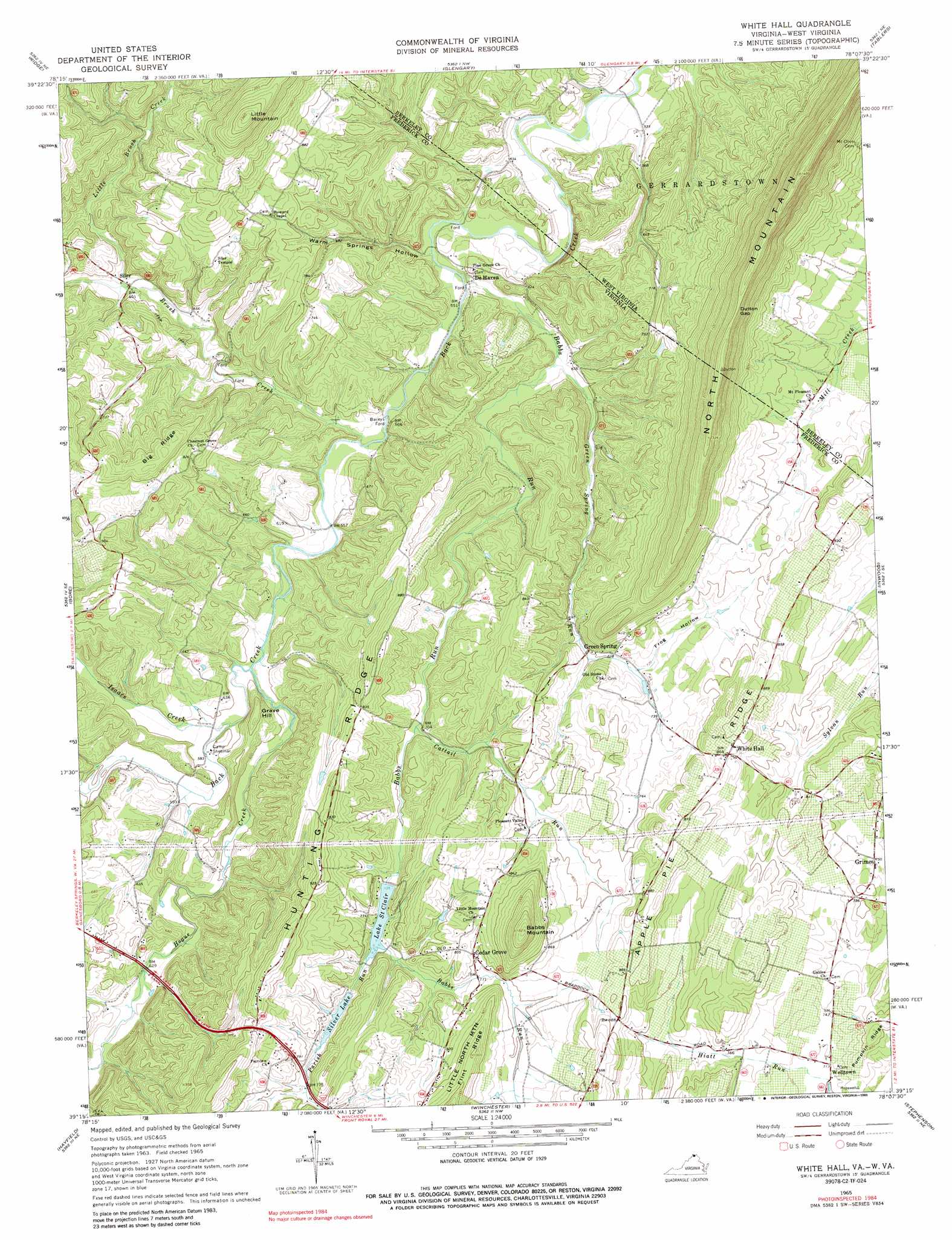
USGS Topo Quad 39078c2 - 1:24,000 scale
| Topo Map Name: | White Hall |
| USGS Topo Quad ID: | 39078c2 |
| Print Size: | ca. 21 1/4" wide x 27" high |
| Southeast Coordinates: | 39.25° N latitude / 78.125° W longitude |
| Map Center Coordinates: | 39.3125° N latitude / 78.1875° W longitude |
| U.S. States: | VA, WV |
| Filename: | o39078c2.jpg |
| Download Map JPG Image: | White Hall topo map 1:24,000 scale |
| Map Type: | Topographic |
| Topo Series: | 7.5´ |
| Map Scale: | 1:24,000 |
| Source of Map Images: | United States Geological Survey (USGS) |
| Alternate Map Versions: |
White Hall VA 1965, updated 1967 Download PDF Buy paper map White Hall VA 1965, updated 1989 Download PDF Buy paper map White Hall VA 2011 Download PDF Buy paper map White Hall VA 2013 Download PDF Buy paper map White Hall VA 2016 Download PDF Buy paper map |
1:24,000 Topo Quads surrounding White Hall
Paw Paw |
Great Cacapon |
Stotlers Crossroads |
Big Pool |
Hedgesville |
Largent |
Ridge |
Glengary |
Tablers Station |
Martinsburg |
Capon Bridge |
Gore |
White Hall |
Inwood |
Middleway |
Capon Springs |
Hayfield |
Winchester |
Stephenson |
Berryville |
Mountain Falls |
Middletown |
Stephens City |
Boyce |
Ashby Gap |
> Back to 39078a1 at 1:100,000 scale
> Back to 39078a1 at 1:250,000 scale
> Back to U.S. Topo Maps home
White Hall topo map: Gazetteer
White Hall: Crossings
Baileys Ford elevation 169m 554′White Hall: Dams
Butler Dam elevation 252m 826′Lake Saint Clair Dam elevation 223m 731′
Silver Lake Dam elevation 229m 751′
White Hall: Gaps
Dutton Gap elevation 395m 1295′White Hall: Populated Places
Braddock Hills Estates elevation 251m 823′Cedar Grove elevation 246m 807′
Chestnut Grove Estates elevation 237m 777′
De Haveland Estates elevation 241m 790′
De Haven elevation 166m 544′
Green Spring elevation 213m 698′
Grimes elevation 229m 751′
Grouse Hollow Estates elevation 240m 787′
Light (historical) elevation 253m 830′
Ole Orchard Estates elevation 226m 741′
Ravenwood Estates elevation 255m 836′
Siler elevation 202m 662′
Sir John Addition elevation 230m 754′
Welltown elevation 217m 711′
White Hall elevation 267m 875′
White Hall: Reservoirs
Lake Saint Clair elevation 247m 810′Lake Saint Clair elevation 223m 731′
Lake Serene elevation 252m 826′
Silver Lake elevation 229m 751′
White Hall: Ridges
Apple Pie Ridge elevation 282m 925′Big Ridge elevation 301m 987′
White Hall: Streams
Babbs Run elevation 164m 538′Brush Creek elevation 166m 544′
Cattail Run elevation 209m 685′
Green Spring Run elevation 175m 574′
Hogue Creek elevation 175m 574′
Isaacs Creek elevation 174m 570′
Little Brush Creek elevation 198m 649′
Little Brush Creek elevation 202m 662′
Parish Run elevation 223m 731′
White Hall: Summits
Babbs Mountain elevation 359m 1177′Grave Hill elevation 227m 744′
Little Mountain elevation 413m 1354′
North Mountain elevation 396m 1299′
White Hall: Valleys
Frog Hollow elevation 219m 718′Warm Springs Hollow elevation 166m 544′
White Hall digital topo map on disk
Buy this White Hall topo map showing relief, roads, GPS coordinates and other geographical features, as a high-resolution digital map file on DVD:
 map DVD")