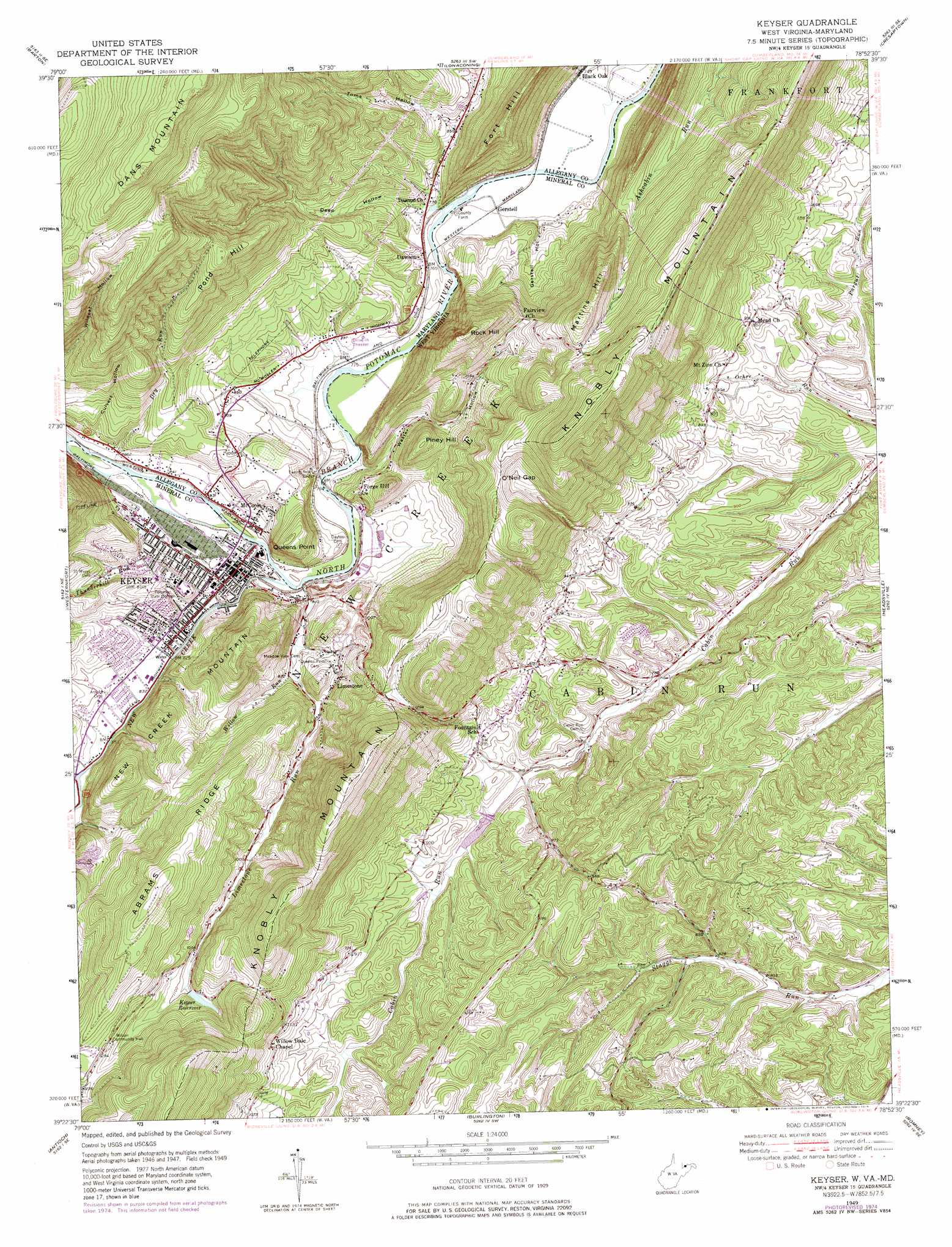
Keyser Topo Map West Virginia
To zoom in, hover over the map of Keyser
USGS Topo Quad 39078d8 - 1:24,000 scale
| Topo Map Name: | Keyser |
| USGS Topo Quad ID: | 39078d8 |
| Print Size: | ca. 21 1/4" wide x 27" high |
| Southeast Coordinates: | 39.375° N latitude / 78.875° W longitude |
| Map Center Coordinates: | 39.4375° N latitude / 78.9375° W longitude |
| U.S. States: | WV, MD |
| Filename: | o39078d8.jpg |
| Download Map JPG Image: | Keyser topo map 1:24,000 scale |
| Map Type: | Topographic |
| Topo Series: | 7.5´ |
| Map Scale: | 1:24,000 |
| Source of Map Images: | United States Geological Survey (USGS) |
| Alternate Map Versions: |
Keyser WV 1949, updated 1965 Download PDF Buy paper map Keyser WV 1949, updated 1972 Download PDF Buy paper map Keyser WV 1949, updated 1976 Download PDF Buy paper map Keyser WV 1951 Download PDF Buy paper map Keyser WV 2011 Download PDF Buy paper map Keyser WV 2014 Download PDF Buy paper map Keyser WV 2016 Download PDF Buy paper map |
1:24,000 Topo Quads surrounding Keyser
Grantsville |
Avilton |
Frostburg |
Cumberland |
Evitts Creek |
Bittinger |
Barton |
Lonaconing |
Cresaptown |
Patterson Creek |
Kitzmiller |
Westernport |
Keyser |
Headsville |
Springfield |
Mount Storm |
Antioch |
Burlington |
Romney |
Augusta |
Greenland Gap |
Medley |
Old Fields |
Sector |
Rio |
> Back to 39078a1 at 1:100,000 scale
> Back to 39078a1 at 1:250,000 scale
> Back to U.S. Topo Maps home
Keyser topo map: Gazetteer
Keyser: Airports
Gerstell Farms Airport elevation 225m 738′Keyser: Bridges
Twenty-First Bridge elevation 241m 790′Keyser: Capes
Queens Point elevation 365m 1197′Keyser: Dams
New Creek Structure Number One Dam elevation 300m 984′Old Keyser Dam elevation 334m 1095′
Patterson Creek Structure Number 28 Dam elevation 257m 843′
Keyser: Gaps
O'Neil Gap elevation 463m 1519′Keyser: Populated Places
Black Oak elevation 221m 725′Dawson elevation 234m 767′
Forge Hill elevation 280m 918′
Gerstell elevation 226m 741′
Keyser elevation 246m 807′
Limestone elevation 302m 990′
McCoole elevation 250m 820′
Noswad (historical) elevation 238m 780′
Keyser: Post Offices
Keyser Post Office elevation 247m 810′Keyser: Reservoirs
Keyser Reservoir elevation 332m 1089′Keyser: Ridges
Abrams Ridge elevation 470m 1541′Keyser: Springs
Willowvale Farm Spring elevation 335m 1099′Keyser: Streams
Dry Run elevation 250m 820′Limestone Run elevation 238m 780′
New Creek elevation 238m 780′
Stony Run elevation 260m 853′
Thunderhill Run elevation 247m 810′
Willow Run elevation 251m 823′
Keyser: Summits
Fort Hill elevation 285m 935′Martins Hill elevation 537m 1761′
Piney Hill elevation 395m 1295′
Pond Hill elevation 546m 1791′
Rock Hill elevation 528m 1732′
Keyser: Valleys
Culvert Hollow elevation 270m 885′Deep Hollow elevation 226m 741′
Gerstell Hollow elevation 235m 770′
Toms Hollow elevation 263m 862′
Waxter Hollow elevation 235m 770′
Keyser digital topo map on disk
Buy this Keyser topo map showing relief, roads, GPS coordinates and other geographical features, as a high-resolution digital map file on DVD:
 map DVD")