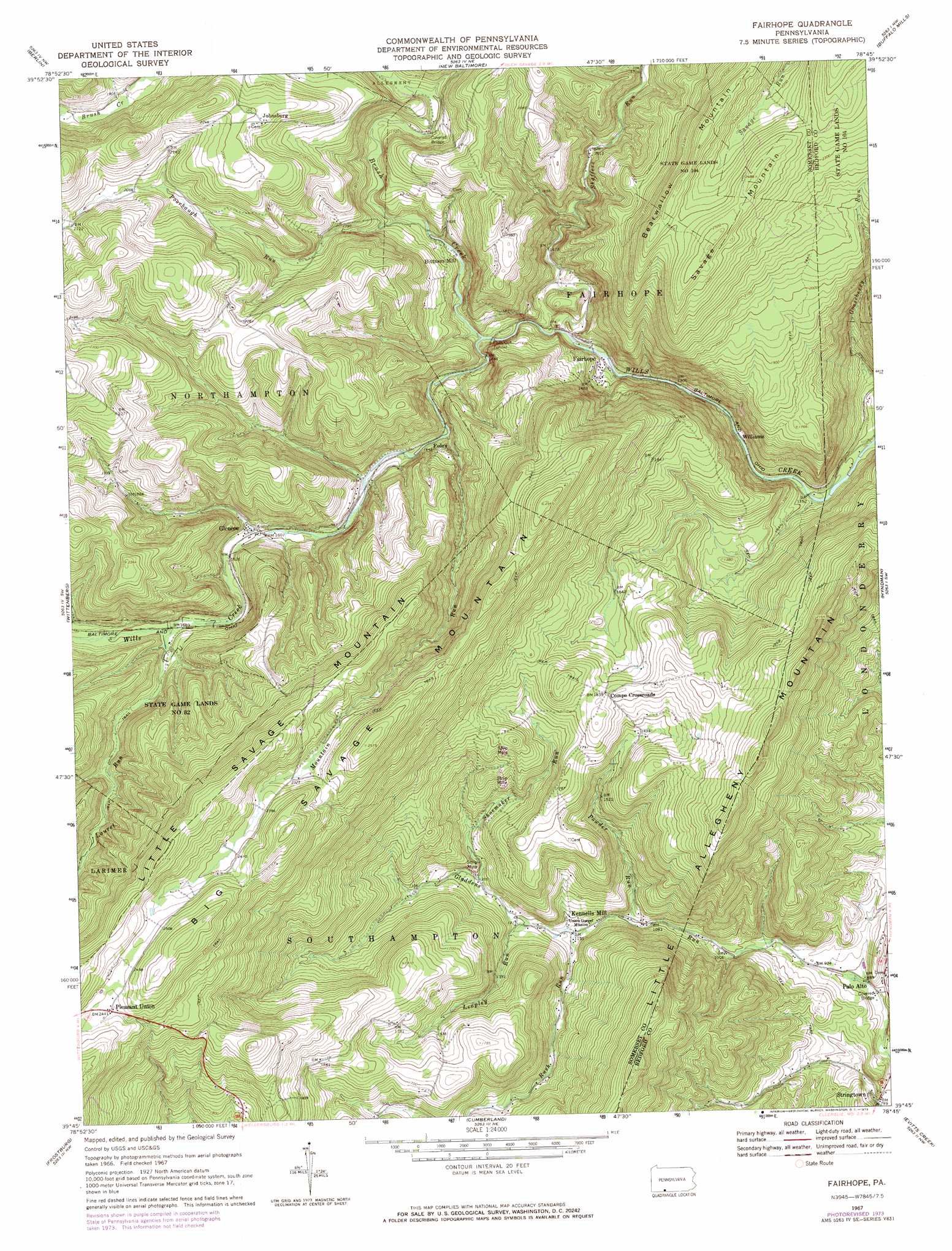
Fairhope Topo Map Pennsylvania
To zoom in, hover over the map of Fairhope
USGS Topo Quad 39078g7 - 1:24,000 scale
| Topo Map Name: | Fairhope |
| USGS Topo Quad ID: | 39078g7 |
| Print Size: | ca. 21 1/4" wide x 27" high |
| Southeast Coordinates: | 39.75° N latitude / 78.75° W longitude |
| Map Center Coordinates: | 39.8125° N latitude / 78.8125° W longitude |
| U.S. State: | PA |
| Filename: | o39078g7.jpg |
| Download Map JPG Image: | Fairhope topo map 1:24,000 scale |
| Map Type: | Topographic |
| Topo Series: | 7.5´ |
| Map Scale: | 1:24,000 |
| Source of Map Images: | United States Geological Survey (USGS) |
| Alternate Map Versions: |
Fairhope PA 1967, updated 1970 Download PDF Buy paper map Fairhope PA 1967, updated 1973 Download PDF Buy paper map Fairhope PA 1967, updated 1973 Download PDF Buy paper map Fairhope PA 1977, updated 1979 Download PDF Buy paper map Fairhope PA 2010 Download PDF Buy paper map Fairhope PA 2013 Download PDF Buy paper map Fairhope PA 2016 Download PDF Buy paper map |
1:24,000 Topo Quads surrounding Fairhope
Somerset |
Stoystown |
Central City |
Schellsburg |
Bedford |
Murdock |
Berlin |
New Baltimore |
Buffalo Mills |
Rainsburg |
Meyersdale |
Wittenberg |
Fairhope |
Hyndman |
Beans Cove |
Avilton |
Frostburg |
Cumberland |
Evitts Creek |
Flintstone |
Barton |
Lonaconing |
Cresaptown |
Patterson Creek |
Oldtown |
> Back to 39078e1 at 1:100,000 scale
> Back to 39078a1 at 1:250,000 scale
> Back to U.S. Topo Maps home
Fairhope topo map: Gazetteer
Fairhope: Bridges
Fitchner Covered Bridge elevation 353m 1158′Fairhope: Populated Places
Bittners Mill elevation 508m 1666′Comps Crossroads elevation 561m 1840′
Fairhope elevation 412m 1351′
Foley elevation 504m 1653′
Glencoe elevation 498m 1633′
Hoblitzell elevation 333m 1092′
Johnsburg elevation 697m 2286′
Kennells Mill elevation 351m 1151′
Palo Alto elevation 275m 902′
Pleasant Union elevation 744m 2440′
Stringtown elevation 243m 797′
Williams elevation 378m 1240′
Fairhope: Streams
Brush Creek elevation 431m 1414′Laurel Run elevation 512m 1679′
Laurel Run elevation 514m 1686′
Leapley Run elevation 367m 1204′
Mountain Run elevation 458m 1502′
Poorbaugh Run elevation 468m 1535′
Powder Run elevation 335m 1099′
Rush Run elevation 351m 1151′
Shaffers Run elevation 419m 1374′
Shoemaker Run elevation 382m 1253′
Fairhope: Summits
Bearwallow Mountain elevation 762m 2500′Big Savage Mountain elevation 782m 2565′
Little Allegheny Mountain elevation 553m 1814′
Fairhope: Tunnels
Falls Cut Tunnel elevation 498m 1633′Fairhope digital topo map on disk
Buy this Fairhope topo map showing relief, roads, GPS coordinates and other geographical features, as a high-resolution digital map file on DVD:
 map DVD")