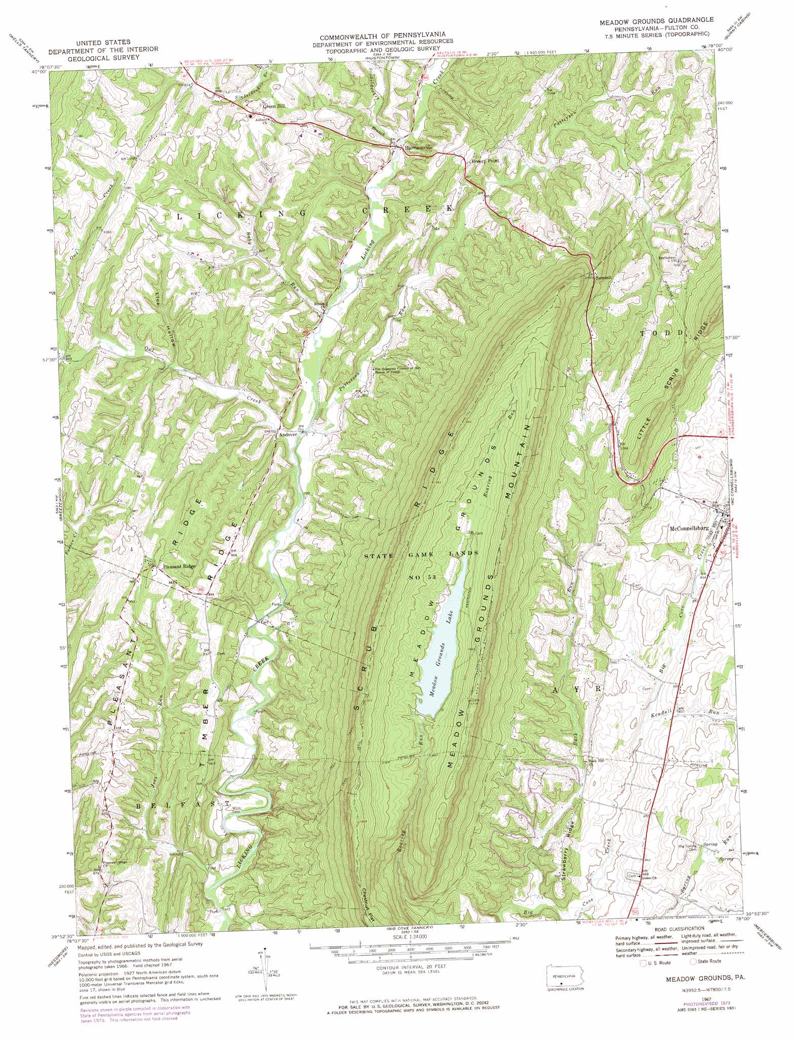
Meadow Grounds Topo Map Pennsylvania
To zoom in, hover over the map of Meadow Grounds
USGS Topo Quad 39078h1 - 1:24,000 scale
| Topo Map Name: | Meadow Grounds |
| USGS Topo Quad ID: | 39078h1 |
| Print Size: | ca. 21 1/4" wide x 27" high |
| Southeast Coordinates: | 39.875° N latitude / 78° W longitude |
| Map Center Coordinates: | 39.9375° N latitude / 78.0625° W longitude |
| U.S. State: | PA |
| Filename: | o39078h1.jpg |
| Download Map JPG Image: | Meadow Grounds topo map 1:24,000 scale |
| Map Type: | Topographic |
| Topo Series: | 7.5´ |
| Map Scale: | 1:24,000 |
| Source of Map Images: | United States Geological Survey (USGS) |
| Alternate Map Versions: |
Meadow Grounds PA 1967, updated 1970 Download PDF Buy paper map Meadow Grounds PA 1967, updated 1973 Download PDF Buy paper map Meadow Grounds PA 1967, updated 1984 Download PDF Buy paper map Meadow Grounds PA 1994, updated 1997 Download PDF Buy paper map Meadow Grounds PA 2010 Download PDF Buy paper map Meadow Grounds PA 2013 Download PDF Buy paper map Meadow Grounds PA 2016 Download PDF Buy paper map |
1:24,000 Topo Quads surrounding Meadow Grounds
Hopewell |
Saxton |
Saltillo |
Orbisonia |
Shade Gap |
Everett East |
Wells Tannery |
Hustontown |
Burnt Cabins |
Fannettsburg |
Mench |
Breezewood |
Meadow Grounds |
Mcconnellsburg |
Saint Thomas |
Amaranth |
Needmore |
Big Cove Tannery |
Mercersburg |
Williamson |
Bellegrove |
Hancock |
Cherry Run |
Clear Spring |
Mason-Dixon |
> Back to 39078e1 at 1:100,000 scale
> Back to 39078a1 at 1:250,000 scale
> Back to U.S. Topo Maps home
Meadow Grounds topo map: Gazetteer
Meadow Grounds: Basins
Meadow Grounds elevation 468m 1535′Meadow Grounds: Dams
Meadow Grounds Dam elevation 472m 1548′Meadow Grounds: Parks
State Game Lands Number 53 elevation 487m 1597′Meadow Grounds: Populated Places
Andover elevation 230m 754′Breezy Point elevation 304m 997′
Green Hill elevation 311m 1020′
Harrisonville elevation 238m 780′
Pleasant Ridge elevation 305m 1000′
Meadow Grounds: Reservoirs
Meadow Grounds Lake elevation 456m 1496′Meadow Grounds: Ridges
Pleasant Ridge elevation 300m 984′Scrub Ridge elevation 560m 1837′
Strawberry Ridge elevation 292m 958′
Meadow Grounds: Streams
Baby Run elevation 230m 754′Back Run elevation 235m 770′
Ditch Run elevation 256m 839′
Joes Run elevation 206m 675′
Kendall Run elevation 248m 813′
Owl Creek elevation 225m 738′
Patterson Run elevation 227m 744′
Sindeldecker Branch elevation 237m 777′
Meadow Grounds: Summits
Meadow Grounds Mountain elevation 520m 1706′Summit elevation 450m 1476′
Meadow Grounds: Valleys
Lick Hollow elevation 243m 797′Meadow Grounds digital topo map on disk
Buy this Meadow Grounds topo map showing relief, roads, GPS coordinates and other geographical features, as a high-resolution digital map file on DVD:
 map DVD")