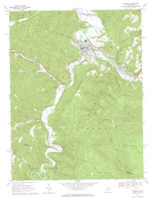
Parsons Topo Map West Virginia
To zoom in, hover over the map of Parsons
USGS Topo Quad 39079a6 - 1:24,000 scale
| Topo Map Name: | Parsons |
| USGS Topo Quad ID: | 39079a6 |
| Print Size: | ca. 21 1/4" wide x 27" high |
| Southeast Coordinates: | 39° N latitude / 79.625° W longitude |
| Map Center Coordinates: | 39.0625° N latitude / 79.6875° W longitude |
| U.S. State: | WV |
| Filename: | o39079a6.jpg |
| Download Map JPG Image: | Parsons topo map 1:24,000 scale |
| Map Type: | Topographic |
| Topo Series: | 7.5´ |
| Map Scale: | 1:24,000 |
| Source of Map Images: | United States Geological Survey (USGS) |
| Alternate Map Versions: |
Parsons WV 1968, updated 1971 Download PDF Buy paper map Parsons WV 1968, updated 1984 Download PDF Buy paper map Parsons WV 1995, updated 1998 Download PDF Buy paper map Parsons WV 1995, updated 1998 Download PDF Buy paper map Parsons WV 2011 Download PDF Buy paper map Parsons WV 2014 Download PDF Buy paper map Parsons WV 2016 Download PDF Buy paper map |
| FStopo: | US Forest Service topo Parsons is available: Download FStopo PDF Download FStopo TIF |
1:24,000 Topo Quads surrounding Parsons
> Back to 39079a1 at 1:100,000 scale
> Back to 39078a1 at 1:250,000 scale
> Back to U.S. Topo Maps home
Parsons topo map: Gazetteer
Parsons: Bridges
Moss Bridge elevation 487m 1597′Parsons: Crossings
Jobs Ford elevation 487m 1597′Parsons: Gaps
Big Springs Gap elevation 749m 2457′Parsons: Parks
Ferron Experimental Forest elevation 631m 2070′Parsons: Populated Places
Bretz elevation 517m 1696′Clover Run (historical) elevation 535m 1755′
Davisville elevation 504m 1653′
Hambleton elevation 525m 1722′
Hendricks elevation 523m 1715′
Moore elevation 553m 1814′
Parsons elevation 502m 1646′
Pettit (historical) elevation 571m 1873′
Pleasant Run elevation 531m 1742′
Porterwood elevation 514m 1686′
Parsons: Post Offices
Parsons Post Office elevation 501m 1643′Parsons: Springs
Elklick Run Spring elevation 659m 2162′Harlan Irons Spring elevation 557m 1827′
Parsons: Streams
Aarons Run elevation 557m 1827′Bear Run elevation 631m 2070′
Bear Run elevation 532m 1745′
Big Spring Run elevation 656m 2152′
Black Fork elevation 494m 1620′
Blackwater River elevation 515m 1689′
Canoe Run elevation 534m 1751′
Devils Dump Run elevation 490m 1607′
Dry Fork elevation 516m 1692′
Elklick Run elevation 508m 1666′
Flatbrush Run elevation 584m 1916′
Fools Run elevation 555m 1820′
Goodwin Run elevation 552m 1811′
Haddix Run elevation 510m 1673′
Hawk Run elevation 506m 1660′
Jobs Run elevation 516m 1692′
Laurel Run elevation 556m 1824′
Laurel Run elevation 525m 1722′
Mill Run elevation 512m 1679′
Nail Run elevation 565m 1853′
Panther Fork elevation 543m 1781′
Pleasant Run elevation 529m 1735′
Roaring Run elevation 506m 1660′
Rock Camp Run elevation 546m 1791′
Shavers Fork elevation 494m 1620′
Shingle Tree Run elevation 532m 1745′
South Branch Haddix Run elevation 534m 1751′
Spring Run elevation 625m 2050′
Stonelick Run elevation 530m 1738′
Sugarcamp Run elevation 505m 1656′
Sugarcamp Run elevation 534m 1751′
Turkey Run elevation 660m 2165′
Parsons: Summits
Fork Mountain elevation 871m 2857′Turkey Knob elevation 764m 2506′
Parsons: Trails
Big Springs Gap Trail elevation 692m 2270′Green Mountain Trail elevation 1026m 3366′
Moore Run Trail elevation 949m 3113′
Shingle Tree Run Trail elevation 602m 1975′
Shingle Tree Trail elevation 655m 2148′
Turkey Run Trail elevation 1117m 3664′
Parsons: Valleys
Camp Hollow elevation 663m 2175′Fishing Trough Hollow elevation 526m 1725′
Hickman Slide Hollow elevation 601m 1971′
John B Hollow elevation 567m 1860′
Slip Hollow elevation 553m 1814′
Smoky Hollow elevation 524m 1719′
Wilson Hollow elevation 616m 2020′
Parsons digital topo map on disk
Buy this Parsons topo map showing relief, roads, GPS coordinates and other geographical features, as a high-resolution digital map file on DVD:


