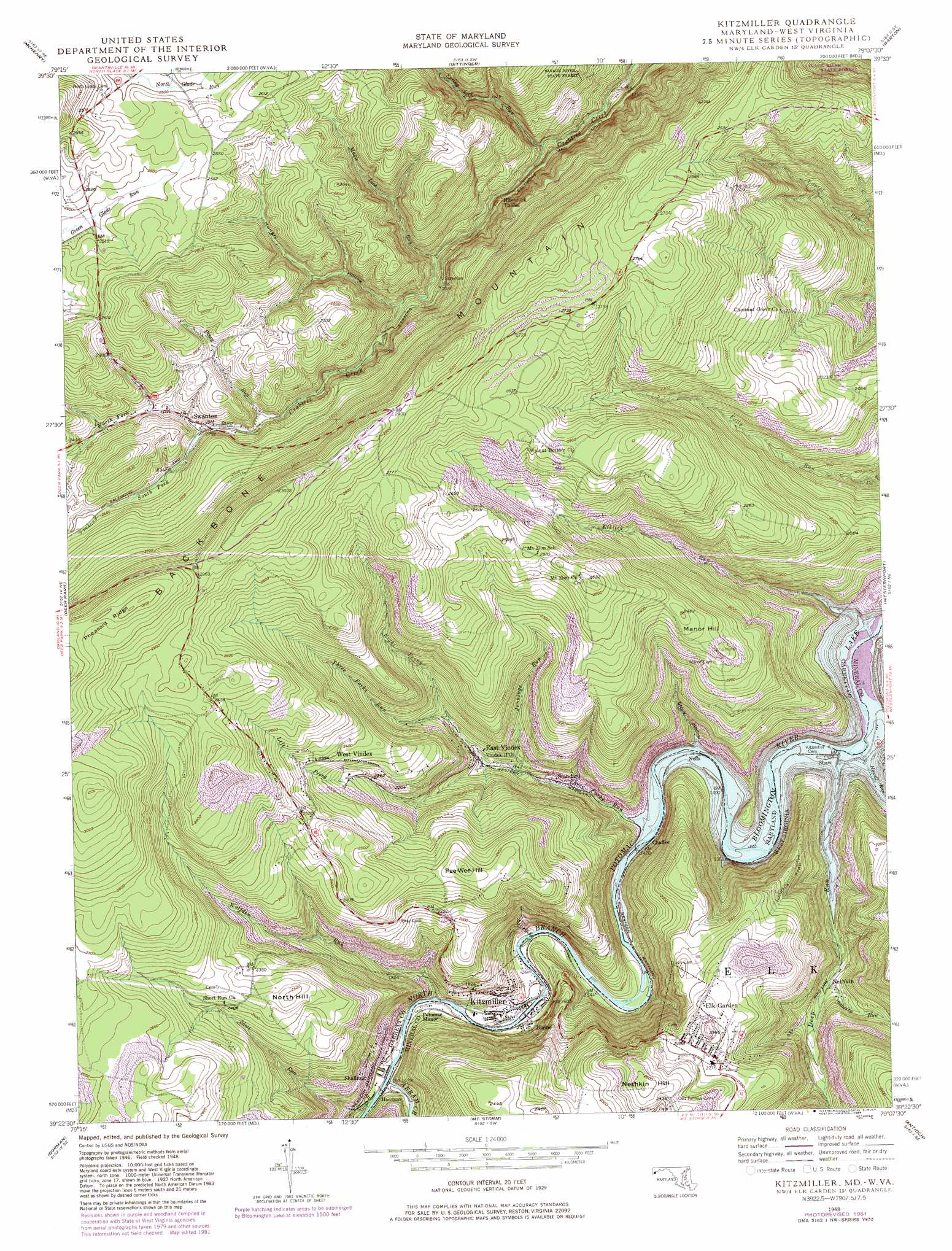
Kitzmiller Topo Map Maryland
To zoom in, hover over the map of Kitzmiller
USGS Topo Quad 39079d2 - 1:24,000 scale
| Topo Map Name: | Kitzmiller |
| USGS Topo Quad ID: | 39079d2 |
| Print Size: | ca. 21 1/4" wide x 27" high |
| Southeast Coordinates: | 39.375° N latitude / 79.125° W longitude |
| Map Center Coordinates: | 39.4375° N latitude / 79.1875° W longitude |
| U.S. States: | MD, WV |
| Filename: | o39079d2.jpg |
| Download Map JPG Image: | Kitzmiller topo map 1:24,000 scale |
| Map Type: | Topographic |
| Topo Series: | 7.5´ |
| Map Scale: | 1:24,000 |
| Source of Map Images: | United States Geological Survey (USGS) |
| Alternate Map Versions: |
Kitzmiller MD 1948, updated 1966 Download PDF Buy paper map Kitzmiller MD 1948, updated 1966 Download PDF Buy paper map Kitzmiller MD 1948, updated 1977 Download PDF Buy paper map Kitzmiller MD 1948, updated 1977 Download PDF Buy paper map Kitzmiller MD 1948, updated 1982 Download PDF Buy paper map Kitzmiller MD 1948, updated 1984 Download PDF Buy paper map Kitzmiller MD 1948, updated 1984 Download PDF Buy paper map Kitzmiller MD 1950 Download PDF Buy paper map Kitzmiller MD 1950, updated 1950 Download PDF Buy paper map Kitzmiller MD 1950, updated 1953 Download PDF Buy paper map Kitzmiller MD 1997, updated 2001 Download PDF Buy paper map Kitzmiller MD 2011 Download PDF Buy paper map Kitzmiller MD 2014 Download PDF Buy paper map Kitzmiller MD 2016 Download PDF Buy paper map |
1:24,000 Topo Quads surrounding Kitzmiller
Friendsville |
Accident |
Grantsville |
Avilton |
Frostburg |
Sang Run |
Mchenry |
Bittinger |
Barton |
Lonaconing |
Oakland |
Deer Park |
Kitzmiller |
Westernport |
Keyser |
Table Rock |
Gorman |
Mount Storm |
Antioch |
Burlington |
Davis |
Mount Storm Lake |
Greenland Gap |
Medley |
Old Fields |
> Back to 39079a1 at 1:100,000 scale
> Back to 39078a1 at 1:250,000 scale
> Back to U.S. Topo Maps home
Kitzmiller topo map: Gazetteer
Kitzmiller: Populated Places
Blaine elevation 497m 1630′Chaffee elevation 451m 1479′
East Vindex elevation 545m 1788′
Elk Garden elevation 699m 2293′
Harrison elevation 512m 1679′
Kitzmiller elevation 489m 1604′
Nethkin elevation 488m 1601′
Shallmar elevation 540m 1771′
Standard elevation 507m 1663′
Strecker elevation 640m 2099′
Swanton elevation 710m 2329′
West Vindex elevation 711m 2332′
Kitzmiller: Post Offices
Blaine Post Office (historical) elevation 489m 1604′Swanton Post Office elevation 720m 2362′
Kitzmiller: Ridges
Black Ridge elevation 785m 2575′Kitzmiller: Springs
Jones Spring elevation 714m 2342′Kitzmiller: Streams
Abram Creek elevation 509m 1669′Cranberry Run elevation 488m 1601′
Deep Run elevation 445m 1459′
Elklick Run elevation 445m 1459′
Howell Run elevation 445m 1459′
Jennings Run elevation 527m 1729′
Left Prong Three Forks Run elevation 535m 1755′
Maple Lick Run elevation 589m 1932′
North Fork Crabtree Creek elevation 702m 2303′
Piney Run elevation 687m 2253′
Right Prong Three Forks Run elevation 590m 1935′
Short Run elevation 514m 1686′
South Fork Crabtree Creek elevation 702m 2303′
Spring Lick Run elevation 531m 1742′
Stony Hollow Run elevation 447m 1466′
Three Forks Run elevation 445m 1459′
Wolfden Run elevation 497m 1630′
Kitzmiller: Summits
Manor Hill elevation 731m 2398′Nethkin Hill elevation 768m 2519′
North Hill elevation 768m 2519′
Pee Wee Hill elevation 754m 2473′
Kitzmiller: Tunnels
Hitchcock Tunnel elevation 628m 2060′Kitzmiller: Valleys
Hungry Hollow elevation 613m 2011′Stony Hollow elevation 445m 1459′
Kitzmiller digital topo map on disk
Buy this Kitzmiller topo map showing relief, roads, GPS coordinates and other geographical features, as a high-resolution digital map file on DVD:
 map DVD")