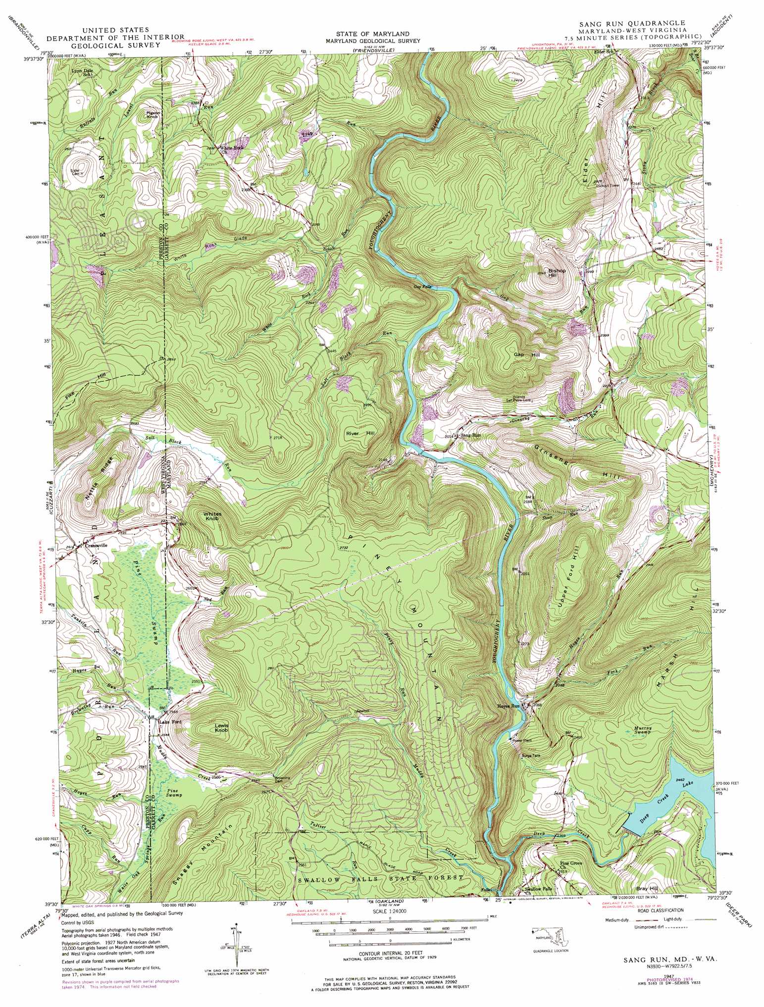
Sang Run Topo Map Maryland
To zoom in, hover over the map of Sang Run
USGS Topo Quad 39079e4 - 1:24,000 scale
| Topo Map Name: | Sang Run |
| USGS Topo Quad ID: | 39079e4 |
| Print Size: | ca. 21 1/4" wide x 27" high |
| Southeast Coordinates: | 39.5° N latitude / 79.375° W longitude |
| Map Center Coordinates: | 39.5625° N latitude / 79.4375° W longitude |
| U.S. States: | MD, WV |
| Filename: | o39079e4.jpg |
| Download Map JPG Image: | Sang Run topo map 1:24,000 scale |
| Map Type: | Topographic |
| Topo Series: | 7.5´ |
| Map Scale: | 1:24,000 |
| Source of Map Images: | United States Geological Survey (USGS) |
| Alternate Map Versions: |
Sang Run MD 1947, updated 1960 Download PDF Buy paper map Sang Run MD 1947, updated 1965 Download PDF Buy paper map Sang Run MD 1947, updated 1976 Download PDF Buy paper map Sang Run MD 1949 Download PDF Buy paper map Sang Run MD 1999, updated 2000 Download PDF Buy paper map Sang Run MD 1999, updated 2000 Download PDF Buy paper map Sang Run MD 2011 Download PDF Buy paper map Sang Run MD 2014 Download PDF Buy paper map Sang Run MD 2016 Download PDF Buy paper map |
1:24,000 Topo Quads surrounding Sang Run
Brownfield |
Fort Necessity |
Ohiopyle |
Confluence |
Markleton |
Bruceton Mills |
Brandonville |
Friendsville |
Accident |
Grantsville |
Valley Point |
Cuzzart |
Sang Run |
Mchenry |
Bittinger |
Kingwood |
Terra Alta |
Oakland |
Deer Park |
Kitzmiller |
Rowlesburg |
Aurora |
Table Rock |
Gorman |
Mount Storm |
> Back to 39079e1 at 1:100,000 scale
> Back to 39078a1 at 1:250,000 scale
> Back to U.S. Topo Maps home
Sang Run topo map: Gazetteer
Sang Run: Dams
Browning Dam elevation 780m 2559′Deep Creek Hydro-Electric Dam elevation 750m 2460′
Sang Run: Falls
Gap Falls elevation 613m 2011′Lower Swallow Falls elevation 662m 2171′
Muddy Creek Falls elevation 705m 2312′
Sang Run: Flats
White Rock Glade elevation 671m 2201′Sang Run: Populated Places
Cranesville elevation 796m 2611′Elder Hill elevation 759m 2490′
Hoyes Run elevation 624m 2047′
Lake Ford elevation 779m 2555′
Sang Run: Post Offices
Sang Run Post Office elevation 615m 2017′Sang Run: Reservoirs
Browning Dam Reservoir elevation 780m 2559′Deep Creek Lake elevation 750m 2460′
Sang Run: Ridges
Dog Ridge elevation 878m 2880′Nettle Ridge elevation 886m 2906′
Sang Run: Streams
Browning Run elevation 775m 2542′Cupp Run elevation 779m 2555′
Deep Creek elevation 640m 2099′
Fork Run elevation 615m 2017′
Gap Run elevation 617m 2024′
Ginseng Run elevation 605m 1984′
Hayes Run elevation 779m 2555′
Hoyes Run elevation 648m 2125′
Hoyes Run elevation 775m 2542′
Muddy Creek elevation 664m 2178′
Muddy Creek elevation 651m 2135′
Ned Run elevation 776m 2545′
Piney Run elevation 758m 2486′
Salt Block Run elevation 607m 1991′
Salt Block Run elevation 611m 2004′
Steep Run elevation 609m 1998′
Stony Brook elevation 606m 1988′
Tankiln Run elevation 778m 2552′
Trap Run elevation 567m 1860′
White Oak Springs Run elevation 773m 2536′
White Rock Glade elevation 681m 2234′
White Rock Run elevation 594m 1948′
Sang Run: Summits
Bishop Hill elevation 829m 2719′Bray Hill elevation 815m 2673′
Elder Hill elevation 860m 2821′
Gap Hill elevation 838m 2749′
Ginseng Hill elevation 864m 2834′
Lewis Knob elevation 905m 2969′
Pigeon Knob elevation 755m 2477′
Piney Mountain elevation 851m 2791′
River Hill elevation 799m 2621′
Upper Ford Hill elevation 888m 2913′
Whites Knob elevation 899m 2949′
Sang Run: Swamps
Murray Swamp elevation 803m 2634′Pine Swamp elevation 775m 2542′
Pine Swamp elevation 776m 2545′
Sang Run digital topo map on disk
Buy this Sang Run topo map showing relief, roads, GPS coordinates and other geographical features, as a high-resolution digital map file on DVD:
 map DVD")