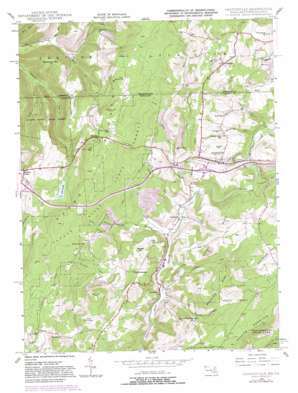
Grantsville Topo Map Maryland
To zoom in, hover over the map of Grantsville
USGS Topo Quad 39079f2 - 1:24,000 scale
| Topo Map Name: | Grantsville |
| USGS Topo Quad ID: | 39079f2 |
| Print Size: | ca. 21 1/4" wide x 27" high |
| Southeast Coordinates: | 39.625° N latitude / 79.125° W longitude |
| Map Center Coordinates: | 39.6875° N latitude / 79.1875° W longitude |
| U.S. States: | MD, PA |
| Filename: | o39079f2.jpg |
| Download Map JPG Image: | Grantsville topo map 1:24,000 scale |
| Map Type: | Topographic |
| Topo Series: | 7.5´ |
| Map Scale: | 1:24,000 |
| Source of Map Images: | United States Geological Survey (USGS) |
| Alternate Map Versions: |
Grantsville MD 1946, updated 1966 Download PDF Buy paper map Grantsville MD 1946, updated 1969 Download PDF Buy paper map Grantsville MD 1946, updated 1976 Download PDF Buy paper map Grantsville MD 1946, updated 1982 Download PDF Buy paper map Grantsville MD 1949 Download PDF Buy paper map Grantsville MD 1949, updated 1949 Download PDF Buy paper map Grantsville MD 1977, updated 1979 Download PDF Buy paper map Grantsville MD 1994, updated 1999 Download PDF Buy paper map Grantsville MD 2011 Download PDF Buy paper map Grantsville MD 2014 Download PDF Buy paper map Grantsville MD 2016 Download PDF Buy paper map |
1:24,000 Topo Quads surrounding Grantsville
> Back to 39079e1 at 1:100,000 scale
> Back to 39078a1 at 1:250,000 scale
> Back to U.S. Topo Maps home
Grantsville topo map: Gazetteer
Grantsville: Bridges
Casselman Bridge elevation 644m 2112′Grantsville: Crossings
Interchange 14 elevation 877m 2877′Interchange 19 elevation 730m 2395′
Grantsville: Dams
Lake Louise Dam elevation 779m 2555′Grantsville: Forests
Savage River State Forest elevation 810m 2657′Grantsville: Mines
Number 1 Mine elevation 722m 2368′Grantsville: Parks
Casselman Bridge State Park elevation 649m 2129′Grantsville: Populated Places
Bevansville elevation 772m 2532′Casselman elevation 656m 2152′
Foxtown elevation 813m 2667′
Grantsville elevation 702m 2303′
Hi-Point elevation 892m 2926′
Jennings elevation 670m 2198′
Niverton elevation 696m 2283′
Springs elevation 756m 2480′
Grantsville: Reservoirs
Lake Louise elevation 834m 2736′Lake Louise elevation 779m 2555′
Yoders Pond elevation 685m 2247′
Grantsville: Ridges
Maynardier Ridge elevation 824m 2703′Grantsville: Streams
Alexander Run elevation 710m 2329′Big Laurel Run elevation 666m 2185′
Big Shade Run elevation 662m 2171′
Big Shade Run elevation 664m 2178′
Bucks Run elevation 621m 2037′
Bucks Run elevation 620m 2034′
Christner Run elevation 653m 2142′
Crab Run elevation 636m 2086′
Enos Run elevation 622m 2040′
Little Laurel Run elevation 668m 2191′
Little Shade Run elevation 664m 2178′
Little Shade Run elevation 664m 2178′
North Branch Casselman River elevation 668m 2191′
Puzzley Run elevation 607m 1991′
Schoolhouse Run elevation 650m 2132′
Shade Run elevation 661m 2168′
Slaubaugh Run elevation 639m 2096′
South Branch Casselman River elevation 666m 2185′
Spiker Run elevation 657m 2155′
Tarkiln Run elevation 695m 2280′
Zehner Run elevation 652m 2139′
Zehner Run elevation 648m 2125′
Grantsville: Summits
Christner Hill elevation 783m 2568′Maust Hill elevation 901m 2956′
Mount Nebo elevation 827m 2713′
Packhorse Mountain elevation 843m 2765′
Resh Hill elevation 846m 2775′
Ridgley Hill elevation 798m 2618′
Ringer Hill elevation 903m 2962′
Shade Hill elevation 741m 2431′
Shoemaker Hill elevation 732m 2401′
Starner Hill elevation 728m 2388′
Strawberry Hill elevation 722m 2368′
Sugar Point elevation 728m 2388′
The Dunghill elevation 829m 2719′
Zehner Hill elevation 908m 2979′
Grantsville digital topo map on disk
Buy this Grantsville topo map showing relief, roads, GPS coordinates and other geographical features, as a high-resolution digital map file on DVD:


