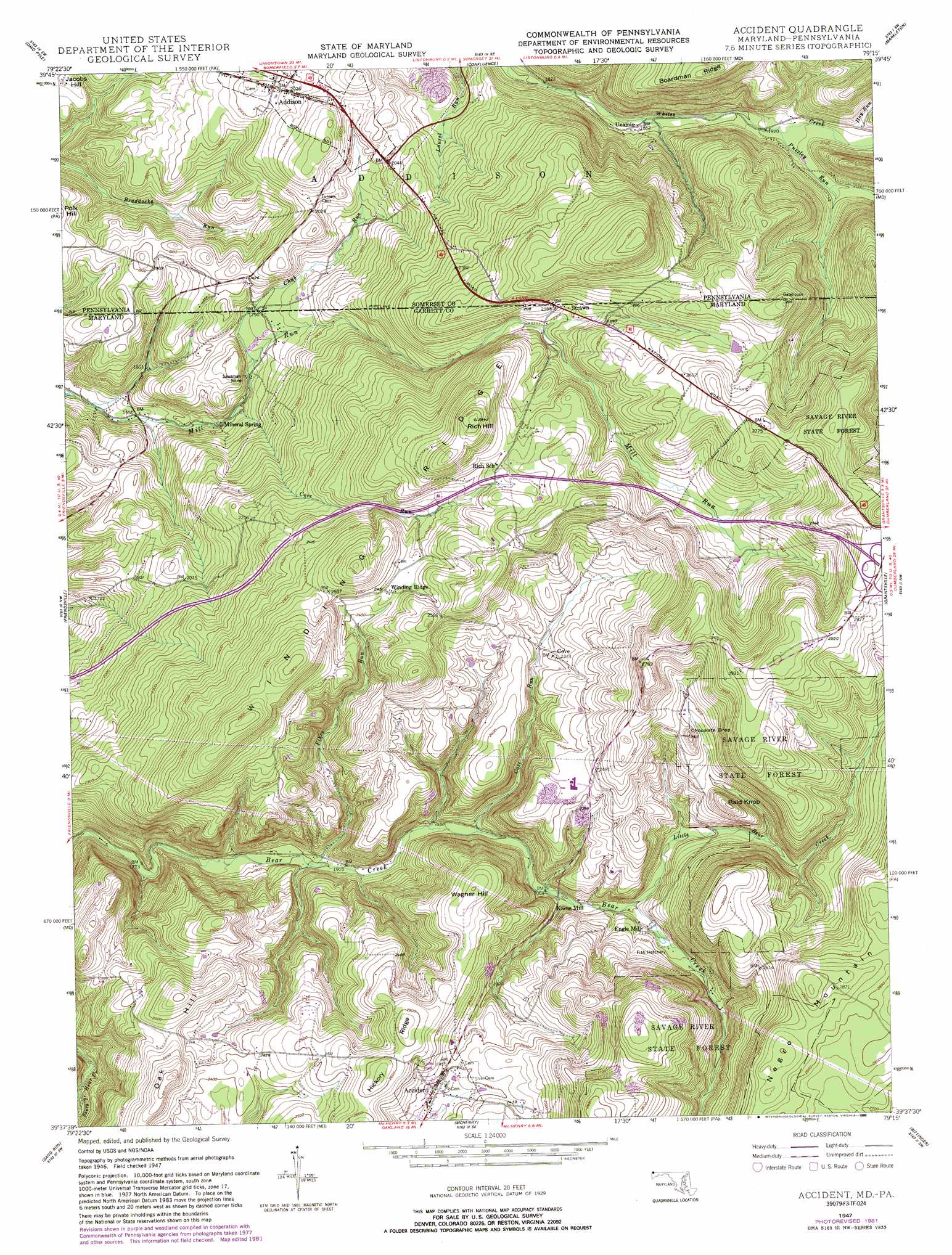
Accident Topo Map Maryland
To zoom in, hover over the map of Accident
USGS Topo Quad 39079f3 - 1:24,000 scale
| Topo Map Name: | Accident |
| USGS Topo Quad ID: | 39079f3 |
| Print Size: | ca. 21 1/4" wide x 27" high |
| Southeast Coordinates: | 39.625° N latitude / 79.25° W longitude |
| Map Center Coordinates: | 39.6875° N latitude / 79.3125° W longitude |
| U.S. States: | MD, PA |
| Filename: | o39079f3.jpg |
| Download Map JPG Image: | Accident topo map 1:24,000 scale |
| Map Type: | Topographic |
| Topo Series: | 7.5´ |
| Map Scale: | 1:24,000 |
| Source of Map Images: | United States Geological Survey (USGS) |
| Alternate Map Versions: |
Accident MD 1947, updated 1982 Download PDF Buy paper map Accident MD 1947, updated 1989 Download PDF Buy paper map Accident MD 1948, updated 1966 Download PDF Buy paper map Accident MD 1948, updated 1975 Download PDF Buy paper map Accident MD 1949 Download PDF Buy paper map Accident MD 1949, updated 1949 Download PDF Buy paper map Accident MD 1977, updated 1979 Download PDF Buy paper map Accident MD 1994, updated 1999 Download PDF Buy paper map Accident MD 2011 Download PDF Buy paper map Accident MD 2014 Download PDF Buy paper map Accident MD 2016 Download PDF Buy paper map |
1:24,000 Topo Quads surrounding Accident
South Connellsville |
Mill Run |
Kingwood |
Rockwood |
Murdock |
Fort Necessity |
Ohiopyle |
Confluence |
Markleton |
Meyersdale |
Brandonville |
Friendsville |
Accident |
Grantsville |
Avilton |
Cuzzart |
Sang Run |
Mchenry |
Bittinger |
Barton |
Terra Alta |
Oakland |
Deer Park |
Kitzmiller |
Westernport |
> Back to 39079e1 at 1:100,000 scale
> Back to 39078a1 at 1:250,000 scale
> Back to U.S. Topo Maps home
Accident topo map: Gazetteer
Accident: Mines
Sausman Mine elevation 527m 1729′Accident: Populated Places
Accident elevation 727m 2385′Addison elevation 624m 2047′
Engle Mill elevation 654m 2145′
Kaese Mill elevation 633m 2076′
Mineral Spring elevation 512m 1679′
Strawn elevation 707m 2319′
Unamis elevation 567m 1860′
Accident: Post Offices
Addison Post Office (historical) elevation 624m 2047′Accident: Ridges
Hickory Ridge elevation 793m 2601′Winding Ridge elevation 774m 2539′
Accident: Springs
Pine Springs elevation 770m 2526′Accident: Streams
Chub Run elevation 532m 1745′Chub Run elevation 537m 1761′
Cove Run elevation 516m 1692′
Cove Run elevation 608m 1994′
Fikes Run elevation 579m 1899′
Hoy Run elevation 611m 2004′
Little Bear Creek elevation 639m 2096′
Puzzley Run elevation 588m 1929′
Accident: Summits
Bald Knob elevation 795m 2608′Chocolate Drop Hill elevation 796m 2611′
Oak Hill elevation 797m 2614′
Rich Hill elevation 858m 2814′
Wagner Hill elevation 792m 2598′
Accident digital topo map on disk
Buy this Accident topo map showing relief, roads, GPS coordinates and other geographical features, as a high-resolution digital map file on DVD:
 map DVD")