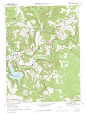
Confluence Topo Map Pennsylvania
To zoom in, hover over the map of Confluence
USGS Topo Quad 39079g3 - 1:24,000 scale
| Topo Map Name: | Confluence |
| USGS Topo Quad ID: | 39079g3 |
| Print Size: | ca. 21 1/4" wide x 27" high |
| Southeast Coordinates: | 39.75° N latitude / 79.25° W longitude |
| Map Center Coordinates: | 39.8125° N latitude / 79.3125° W longitude |
| U.S. State: | PA |
| Filename: | o39079g3.jpg |
| Download Map JPG Image: | Confluence topo map 1:24,000 scale |
| Map Type: | Topographic |
| Topo Series: | 7.5´ |
| Map Scale: | 1:24,000 |
| Source of Map Images: | United States Geological Survey (USGS) |
| Alternate Map Versions: |
Confluence PA 1967, updated 1970 Download PDF Buy paper map Confluence PA 1967, updated 1973 Download PDF Buy paper map Confluence PA 1967, updated 1983 Download PDF Buy paper map Confluence PA 1967, updated 1983 Download PDF Buy paper map Confluence PA 1977, updated 1979 Download PDF Buy paper map Confluence PA 1994, updated 1997 Download PDF Buy paper map Confluence PA 2010 Download PDF Buy paper map Confluence PA 2013 Download PDF Buy paper map Confluence PA 2016 Download PDF Buy paper map |
1:24,000 Topo Quads surrounding Confluence
> Back to 39079e1 at 1:100,000 scale
> Back to 39078a1 at 1:250,000 scale
> Back to U.S. Topo Maps home
Confluence topo map: Gazetteer
Confluence: Bends
Horseshoe Bend elevation 443m 1453′Confluence: Dams
Youghiogheny Dam elevation 442m 1450′Confluence: Parks
State Game Lands Number 271 elevation 760m 2493′Confluence: Populated Places
Beachly elevation 459m 1505′Confluence elevation 407m 1335′
Draketown elevation 513m 1683′
Dumas elevation 428m 1404′
Fort Hill elevation 481m 1578′
Harnedsville elevation 427m 1400′
Humbert elevation 441m 1446′
Listonburg elevation 525m 1722′
Paddytown elevation 565m 1853′
Ursina elevation 412m 1351′
Confluence: Reservoirs
Youghiogheny River Lake elevation 438m 1437′Confluence: Ridges
Boardman Ridge elevation 743m 2437′Klondike Ridge elevation 568m 1863′
Confluence: Streams
Alex Run elevation 590m 1935′Becket Run elevation 447m 1466′
Casselman River elevation 396m 1299′
Cucumber Run elevation 430m 1410′
Glade Run elevation 620m 2034′
Hen Run elevation 403m 1322′
Laurel Hill Creek elevation 402m 1318′
Laurel Run elevation 519m 1702′
Licking Run elevation 402m 1318′
Little Glade Run elevation 543m 1781′
Lost Run elevation 463m 1519′
May Run elevation 437m 1433′
McClintock Run elevation 433m 1420′
Whites Creek elevation 412m 1351′
Confluence: Summits
Fort Hill elevation 601m 1971′Confluence: Tunnels
Benford Tunnel elevation 456m 1496′Brooks Tunnel elevation 515m 1689′
Shoofly Tunnel elevation 491m 1610′
Confluence: Valleys
Coke Oven Hollow elevation 450m 1476′Paddytown Hollow elevation 431m 1414′
Smith Hollow elevation 433m 1420′
Confluence digital topo map on disk
Buy this Confluence topo map showing relief, roads, GPS coordinates and other geographical features, as a high-resolution digital map file on DVD:


