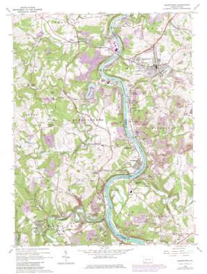
Masontown Topo Map Pennsylvania
To zoom in, hover over the map of Masontown
USGS Topo Quad 39079g8 - 1:24,000 scale
| Topo Map Name: | Masontown |
| USGS Topo Quad ID: | 39079g8 |
| Print Size: | ca. 21 1/4" wide x 27" high |
| Southeast Coordinates: | 39.75° N latitude / 79.875° W longitude |
| Map Center Coordinates: | 39.8125° N latitude / 79.9375° W longitude |
| U.S. State: | PA |
| Filename: | o39079g8.jpg |
| Download Map JPG Image: | Masontown topo map 1:24,000 scale |
| Map Type: | Topographic |
| Topo Series: | 7.5´ |
| Map Scale: | 1:24,000 |
| Source of Map Images: | United States Geological Survey (USGS) |
| Alternate Map Versions: |
Masontown PA 1964, updated 1966 Download PDF Buy paper map Masontown PA 1964, updated 1973 Download PDF Buy paper map Masontown PA 1964, updated 1979 Download PDF Buy paper map Masontown PA 2010 Download PDF Buy paper map Masontown PA 2013 Download PDF Buy paper map Masontown PA 2016 Download PDF Buy paper map |
1:24,000 Topo Quads surrounding Masontown
> Back to 39079e1 at 1:100,000 scale
> Back to 39078a1 at 1:250,000 scale
> Back to U.S. Topo Maps home
Masontown topo map: Gazetteer
Masontown: Airports
Gallatin Fuel Heliport elevation 335m 1099′Lee Norse Number Five Heliport elevation 362m 1187′
Masontown: Dams
Monongahela River Lock and Dam Seven elevation 255m 836′Robena Slope Mine Dam elevation 247m 810′
Robena Slope Mine Refuse Bank Dam elevation 247m 810′
Robena Slurry Pond Number Six Dam elevation 294m 964′
Masontown: Mines
Poland Mines elevation 274m 898′Masontown: Parks
Friendship Hill National Historic Site elevation 300m 984′Masontown: Populated Places
Atlantic elevation 304m 997′Bobtown elevation 362m 1187′
Cabbage Flats elevation 287m 941′
Cats Run Junction elevation 242m 793′
Ceylon elevation 298m 977′
Dilliner elevation 257m 843′
Fayette elevation 245m 803′
Fieldsons Crossroads elevation 332m 1089′
Friendship Heights elevation 284m 931′
Gallatin elevation 258m 846′
Glassworks elevation 249m 816′
Grays Landing elevation 240m 787′
Greater Point Marion elevation 297m 974′
Greensboro elevation 243m 797′
Griffin elevation 290m 951′
Headlee Heights elevation 359m 1177′
Huron elevation 250m 820′
Lardin elevation 308m 1010′
Little Chicago elevation 282m 925′
Live Easy elevation 287m 941′
Mable Hill elevation 276m 905′
Mapletown elevation 294m 964′
Martin elevation 301m 987′
Masontown elevation 319m 1046′
Moffitt Sterling elevation 335m 1099′
Mount Sterling elevation 250m 820′
New Geneva elevation 296m 971′
Newtown elevation 295m 967′
Paisley elevation 291m 954′
Penn Pitt elevation 288m 944′
Rocks Works elevation 284m 931′
Ronco elevation 314m 1030′
Sigsbee elevation 314m 1030′
Sprucetown elevation 268m 879′
Sunshine elevation 253m 830′
Wiley elevation 335m 1099′
Willow Tree elevation 303m 994′
Winstead elevation 251m 823′
Masontown: Reservoirs
Active Uellow Boy Pond elevation 247m 810′Monongahela River Pool Seven elevation 255m 836′
Pond Four elevation 247m 810′
Masontown: Streams
Browns Run elevation 234m 767′Cats Run elevation 233m 764′
Dunkard Creek elevation 258m 846′
Dunkard Creek elevation 237m 777′
Georges Creek elevation 237m 777′
Goose Run elevation 297m 974′
Jacobs Creek elevation 238m 780′
Little Whiteley Creek elevation 241m 790′
War Branch elevation 274m 898′
Whiteley Creek elevation 241m 790′
Masontown: Summits
Friendship Hill elevation 318m 1043′Locks Hill elevation 365m 1197′
Sunshine Hill elevation 365m 1197′
Turkey Knob elevation 441m 1446′
Masontown: Valleys
Mundell Hollow elevation 263m 862′Mundell Hollow elevation 282m 925′
Rocky Hollow elevation 262m 859′
Tomcat Hollow elevation 257m 843′
Masontown digital topo map on disk
Buy this Masontown topo map showing relief, roads, GPS coordinates and other geographical features, as a high-resolution digital map file on DVD:


