New Salem Topo Map Pennsylvania
To zoom in, hover over the map of New Salem
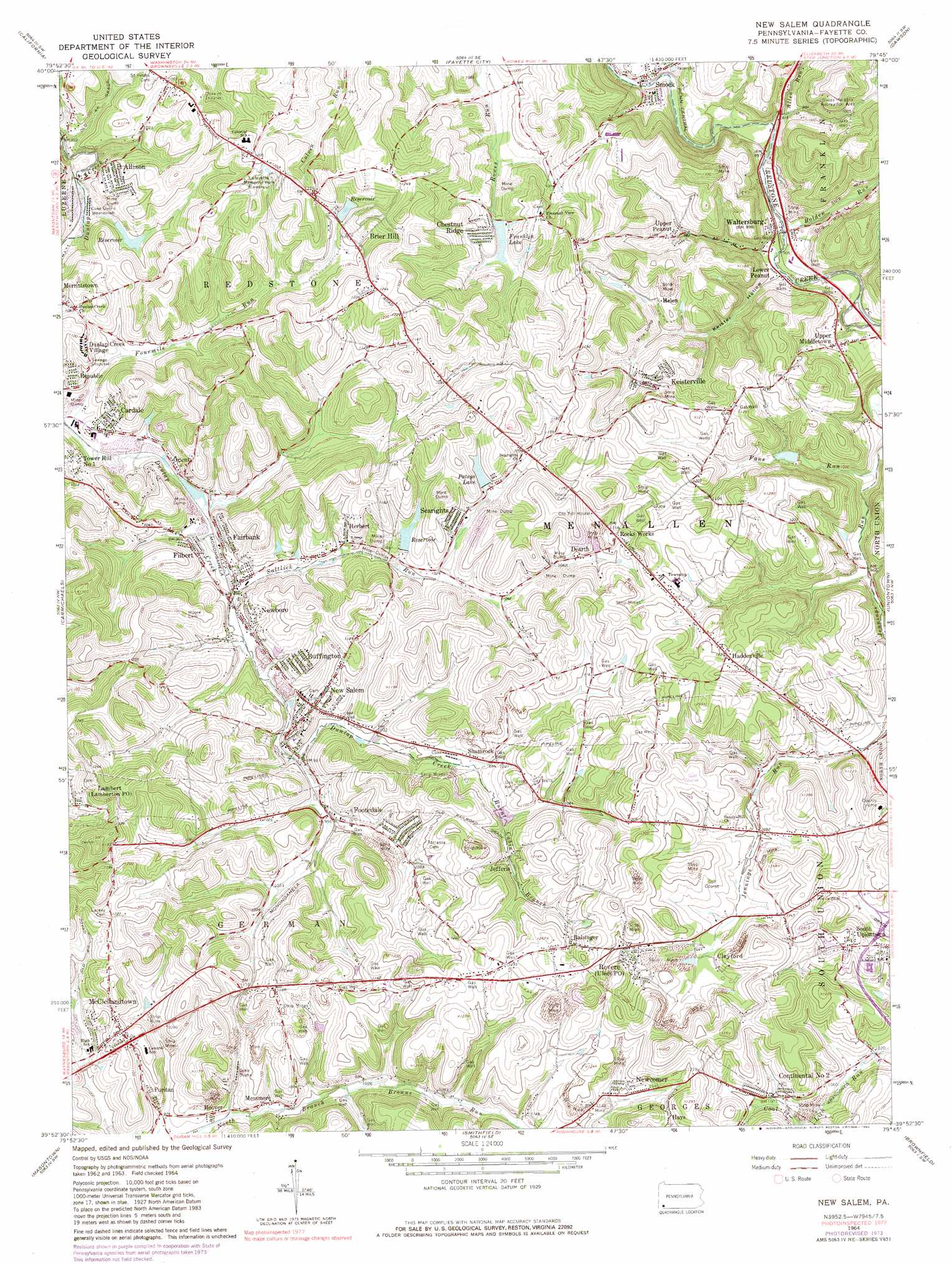
USGS Topo Quad 39079h7 - 1:24,000 scale
| Topo Map Name: | New Salem |
| USGS Topo Quad ID: | 39079h7 |
| Print Size: | ca. 21 1/4" wide x 27" high |
| Southeast Coordinates: | 39.875° N latitude / 79.75° W longitude |
| Map Center Coordinates: | 39.9375° N latitude / 79.8125° W longitude |
| U.S. State: | PA |
| Filename: | o39079h7.jpg |
| Download Map JPG Image: | New Salem topo map 1:24,000 scale |
| Map Type: | Topographic |
| Topo Series: | 7.5´ |
| Map Scale: | 1:24,000 |
| Source of Map Images: | United States Geological Survey (USGS) |
| Alternate Map Versions: |
New Salem PA 1964, updated 1965 Download PDF Buy paper map New Salem PA 1964, updated 1973 Download PDF Buy paper map New Salem PA 1964, updated 1980 Download PDF Buy paper map New Salem PA 1964, updated 1980 Download PDF Buy paper map New Salem PA 2010 Download PDF Buy paper map New Salem PA 2013 Download PDF Buy paper map New Salem PA 2016 Download PDF Buy paper map |
1:24,000 Topo Quads surrounding New Salem
Hackett |
Monongahela |
Donora |
Smithton |
Mount Pleasant |
Ellsworth |
California |
Fayette City |
Saint Clairsville |
Connellsville |
Mather |
Carmichaels |
New Salem |
Uniontown |
South Connellsville |
Garards Fort |
Masontown |
Smithfield |
Brownfield |
Fort Necessity |
Osage |
Morgantown North |
Lake Lynn |
Bruceton Mills |
Brandonville |
> Back to 39079e1 at 1:100,000 scale
> Back to 39078a1 at 1:250,000 scale
> Back to U.S. Topo Maps home
New Salem topo map: Gazetteer
New Salem: Dams
Allison Dam elevation 289m 948′Dunlap Creek Watershed Site Dam elevation 323m 1059′
Keister Run Dam elevation 337m 1105′
Pa-470 Dam elevation 340m 1115′
Patsys Lake Dam elevation 323m 1059′
Royal Reservoir Dam elevation 308m 1010′
New Salem: Parks
Lafayette Memorial Park elevation 354m 1161′Swiss Heights Recreation Area elevation 362m 1187′
New Salem: Populated Places
Allison elevation 325m 1066′Balsinger elevation 375m 1230′
Brier Hill elevation 346m 1135′
Buffington elevation 313m 1026′
Cardale elevation 294m 964′
Chestnut Ridge elevation 312m 1023′
Clayford elevation 367m 1204′
Continental Number 2 elevation 335m 1099′
Davidson elevation 356m 1167′
Dearth elevation 334m 1095′
Dunlap Creek Village elevation 311m 1020′
Fairbank elevation 300m 984′
Filbert elevation 295m 967′
Footedale elevation 322m 1056′
Haddenville elevation 373m 1223′
Hays elevation 368m 1207′
Helen elevation 324m 1062′
Herbert elevation 304m 997′
Hoover elevation 296m 971′
Jefferis elevation 328m 1076′
Keisterville elevation 357m 1171′
Lambert elevation 339m 1112′
Lower Peanut elevation 278m 912′
McClellandtown elevation 336m 1102′
Messmore elevation 303m 994′
New Salem elevation 317m 1040′
Newboro elevation 308m 1010′
Newcomer elevation 348m 1141′
Orient elevation 307m 1007′
Puritan elevation 295m 967′
Rocks Works elevation 360m 1181′
Rothruck elevation 287m 941′
Sandy Hill (historical) elevation 348m 1141′
Sea Right elevation 342m 1122′
Searights elevation 322m 1056′
Shamrock elevation 333m 1092′
Smock elevation 269m 882′
Tuckertown elevation 373m 1223′
Uledi elevation 362m 1187′
Upper Middletown elevation 301m 987′
Upper Peanut elevation 329m 1079′
Waltersburg elevation 273m 895′
New Salem: Post Offices
McClellandtown Post Office elevation 343m 1125′New Salem: Reservoirs
Allison Reservoir elevation 289m 948′Dunlap Creek Watershed Reservoir elevation 323m 1059′
Franklin Lake elevation 323m 1059′
Pa-470 Reservoir elevation 340m 1115′
Patsys Lake elevation 332m 1089′
New Salem: Streams
Allen Run elevation 321m 1053′Bolden Run elevation 272m 892′
Burnt Cabin Branch elevation 314m 1030′
Fourmile Run elevation 291m 954′
Saltlick Run elevation 301m 987′
New Salem: Valleys
Keister Hollow elevation 279m 915′New Salem digital topo map on disk
Buy this New Salem topo map showing relief, roads, GPS coordinates and other geographical features, as a high-resolution digital map file on DVD:
 map DVD")