Audra Topo Map West Virginia
To zoom in, hover over the map of Audra
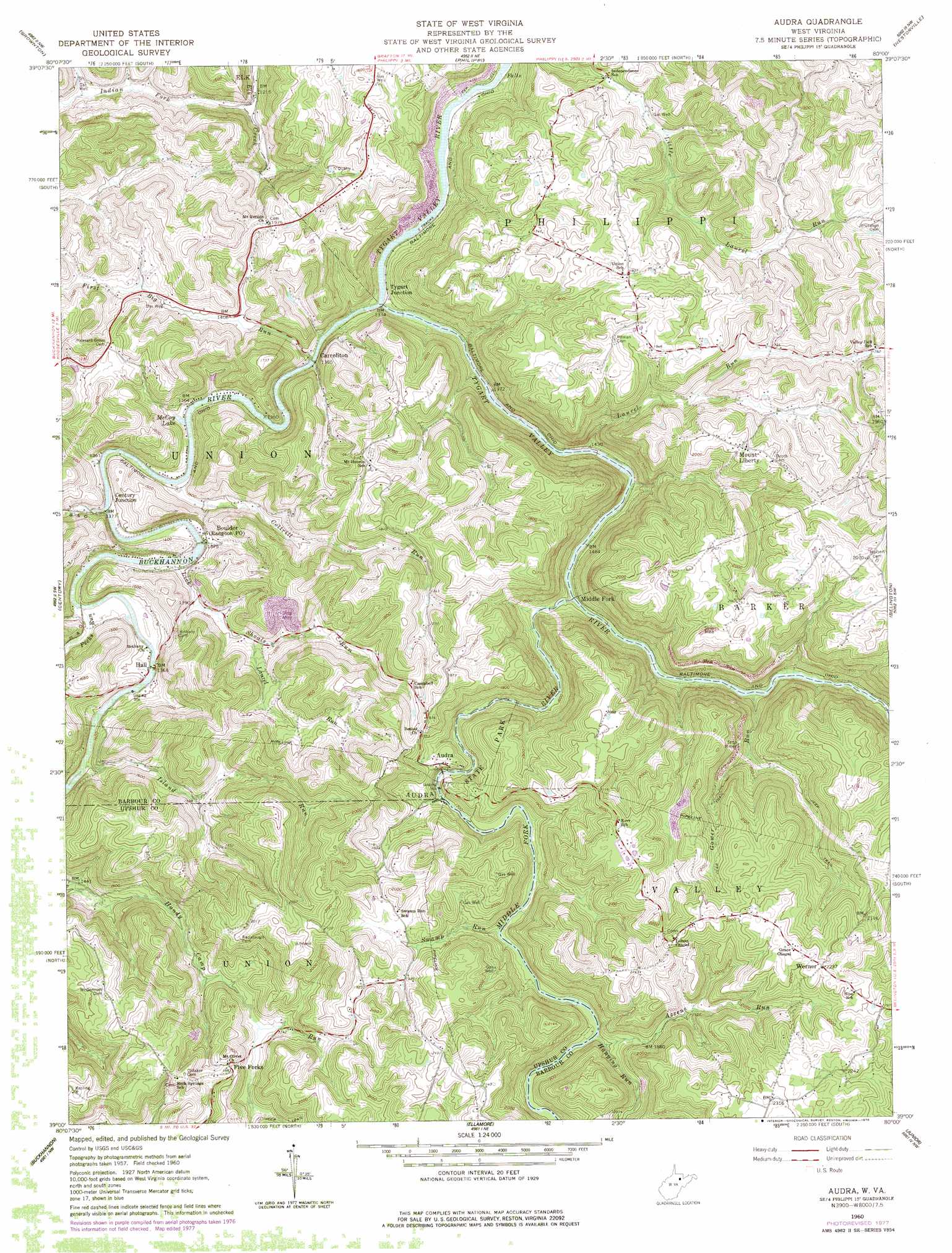
USGS Topo Quad 39080a1 - 1:24,000 scale
| Topo Map Name: | Audra |
| USGS Topo Quad ID: | 39080a1 |
| Print Size: | ca. 21 1/4" wide x 27" high |
| Southeast Coordinates: | 39° N latitude / 80° W longitude |
| Map Center Coordinates: | 39.0625° N latitude / 80.0625° W longitude |
| U.S. State: | WV |
| Filename: | o39080a1.jpg |
| Download Map JPG Image: | Audra topo map 1:24,000 scale |
| Map Type: | Topographic |
| Topo Series: | 7.5´ |
| Map Scale: | 1:24,000 |
| Source of Map Images: | United States Geological Survey (USGS) |
| Alternate Map Versions: |
Audra WV 1960, updated 1962 Download PDF Buy paper map Audra WV 1960, updated 1973 Download PDF Buy paper map Audra WV 1960, updated 1978 Download PDF Buy paper map Audra WV 2011 Download PDF Buy paper map Audra WV 2014 Download PDF Buy paper map Audra WV 2016 Download PDF Buy paper map |
1:24,000 Topo Quads surrounding Audra
Clarksburg |
Rosemont |
Grafton |
Thornton |
Fellowsville |
Mount Clare |
Brownton |
Philippi |
Nestorville |
Colebank |
Berlin |
Century |
Audra |
Belington |
Montrose |
Adrian |
Buckhannon |
Ellamore |
Junior |
Elkins |
Rock Cave |
Alton |
Cassity |
Beverly West |
Beverly East |
> Back to 39080a1 at 1:100,000 scale
> Back to 39080a1 at 1:250,000 scale
> Back to U.S. Topo Maps home
Audra topo map: Gazetteer
Audra: Airports
Simpson Airport elevation 593m 1945′Audra: Bridges
Carrollton Covered Bridge elevation 411m 1348′Audra: Parks
Audra State Park elevation 525m 1722′Audra: Populated Places
Adma (historical) elevation 440m 1443′Audra elevation 531m 1742′
Boulder elevation 420m 1377′
Carrollton elevation 414m 1358′
Century Junction elevation 423m 1387′
Clements (historical) elevation 486m 1594′
Five Forks elevation 576m 1889′
Independence elevation 493m 1617′
Lillian (historical) elevation 406m 1332′
Middle Fork elevation 463m 1519′
Mount Liberty elevation 611m 2004′
O'Brien (historical) elevation 470m 1541′
Swamp Run elevation 597m 1958′
Tygart Junction elevation 407m 1335′
Union elevation 565m 1853′
Werner elevation 680m 2230′
Audra: Post Offices
Rangoon Post Office elevation 420m 1377′Audra: Reservoirs
McCoy Lake elevation 417m 1368′Audra: Streams
Azzens Run elevation 554m 1817′Big Run elevation 417m 1368′
Buckhannon River elevation 404m 1325′
Cottrill Run elevation 415m 1361′
First Big Run elevation 411m 1348′
Gower Run elevation 475m 1558′
Hanging Run elevation 542m 1778′
Indian Fork elevation 374m 1227′
Island Run elevation 423m 1387′
Laurel Run elevation 427m 1400′
Laurel Run elevation 432m 1417′
Lick Shoals Run elevation 417m 1368′
Middle Fork River elevation 452m 1482′
Pecks Run elevation 417m 1368′
Swamp Run elevation 531m 1742′
Audra digital topo map on disk
Buy this Audra topo map showing relief, roads, GPS coordinates and other geographical features, as a high-resolution digital map file on DVD:
 map DVD")