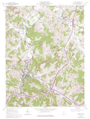
Weston Topo Map West Virginia
To zoom in, hover over the map of Weston
USGS Topo Quad 39080a4 - 1:24,000 scale
| Topo Map Name: | Weston |
| USGS Topo Quad ID: | 39080a4 |
| Print Size: | ca. 21 1/4" wide x 27" high |
| Southeast Coordinates: | 39° N latitude / 80.375° W longitude |
| Map Center Coordinates: | 39.0625° N latitude / 80.4375° W longitude |
| U.S. State: | WV |
| Filename: | o39080a4.jpg |
| Download Map JPG Image: | Weston topo map 1:24,000 scale |
| Map Type: | Topographic |
| Topo Series: | 7.5´ |
| Map Scale: | 1:24,000 |
| Source of Map Images: | United States Geological Survey (USGS) |
| Alternate Map Versions: |
Weston WV 1961, updated 1962 Download PDF Buy paper map Weston WV 1961, updated 1974 Download PDF Buy paper map Weston WV 1961, updated 1978 Download PDF Buy paper map Weston WV 2011 Download PDF Buy paper map Weston WV 2014 Download PDF Buy paper map Weston WV 2016 Download PDF Buy paper map |
1:24,000 Topo Quads surrounding Weston
> Back to 39080a1 at 1:100,000 scale
> Back to 39080a1 at 1:250,000 scale
> Back to U.S. Topo Maps home
Weston topo map: Gazetteer
Weston: Airports
Louis Bennett Field elevation 307m 1007′Weston: Crossings
Interchange 105 elevation 313m 1026′Interchange 96 elevation 311m 1020′
Interchange 99 elevation 321m 1053′
Weston: Dams
Bendale Dam elevation 334m 1095′Jacksons Mill Dam elevation 339m 1112′
Weston Dam elevation 313m 1026′
Weston: Parks
Weston City Park elevation 312m 1023′Weston Downtown Historic District elevation 310m 1017′
Weston: Populated Places
Ben Dale elevation 315m 1033′Brownsville elevation 327m 1072′
Buck Hill elevation 371m 1217′
Butchersville elevation 312m 1023′
Circle Heights elevation 336m 1102′
Cox Town elevation 320m 1049′
Deanville elevation 319m 1046′
Dolan Trailer Park elevation 330m 1082′
Donlan Heights elevation 315m 1033′
Edgewood elevation 332m 1089′
Fisher Hill elevation 372m 1220′
Garton Village elevation 318m 1043′
Gaston elevation 315m 1033′
Gaston Manor elevation 338m 1108′
Haleville elevation 319m 1046′
Hall Addition elevation 317m 1040′
Hall Trailer Park elevation 317m 1040′
Hickory Hills elevation 351m 1151′
Homeland elevation 315m 1033′
Homewood elevation 314m 1030′
Horner elevation 319m 1046′
Jackson Acres elevation 316m 1036′
Jackson Heights elevation 316m 1036′
Jackson Mill elevation 322m 1056′
Jane Lew elevation 310m 1017′
Kitsonville elevation 315m 1033′
Lightburn Acres elevation 328m 1076′
Los Anglin elevation 311m 1020′
Mace Addition elevation 316m 1036′
McGary elevation 317m 1040′
McGuire Park elevation 319m 1046′
Pinecrest Addition elevation 316m 1036′
Quiet Dale elevation 316m 1036′
Riverview Heights elevation 313m 1026′
Shady Brook elevation 320m 1049′
Smith Village elevation 314m 1030′
South Park elevation 328m 1076′
South Park Trailer Park elevation 323m 1059′
Straley Addition elevation 313m 1026′
Sunset Acres elevation 320m 1049′
Turnertown elevation 313m 1026′
Valley Chapel elevation 310m 1017′
Westfield elevation 322m 1056′
Weston elevation 311m 1020′
Weston Arbors elevation 313m 1026′
Weston Manor elevation 317m 1040′
Woodland Addition elevation 332m 1089′
Weston: Post Offices
Horner Post Office elevation 321m 1053′Jane Lew Post Office elevation 309m 1013′
Valley Chapel Post Office elevation 310m 1017′
Weston Post Office elevation 310m 1017′
Weston: Reservoirs
Bendale Lake elevation 334m 1095′Jacksons Mill Lake elevation 339m 1112′
Weston: Streams
Calf Run elevation 307m 1007′Freemans Creek elevation 302m 990′
Geelick Run elevation 303m 994′
Grass Run elevation 313m 1026′
Herdman Run elevation 312m 1023′
Hilly Upland Run elevation 312m 1023′
Horse Run elevation 309m 1013′
Jesse Run elevation 307m 1007′
Lifes Run elevation 308m 1010′
Maxwell Run elevation 307m 1007′
McCann Run elevation 299m 980′
McKinney Run elevation 303m 994′
Middle Run elevation 307m 1007′
Millstone Run elevation 309m 1013′
Mud Lick elevation 310m 1017′
Murphy Creek elevation 307m 1007′
Polk Creek elevation 311m 1020′
Rush Run elevation 312m 1023′
Sauls Run elevation 315m 1033′
Simpson Run elevation 305m 1000′
Smith Run elevation 308m 1010′
Stone Lick elevation 311m 1020′
Stonecoal Creek elevation 308m 1010′
Stony Run elevation 310m 1017′
Sycamore Lick elevation 304m 997′
Town Run elevation 310m 1017′
Washburn Run elevation 330m 1082′
West Run elevation 307m 1007′
Weston: Summits
Fisher Summit elevation 386m 1266′Purgatory Hill elevation 538m 1765′
Weston digital topo map on disk
Buy this Weston topo map showing relief, roads, GPS coordinates and other geographical features, as a high-resolution digital map file on DVD:


