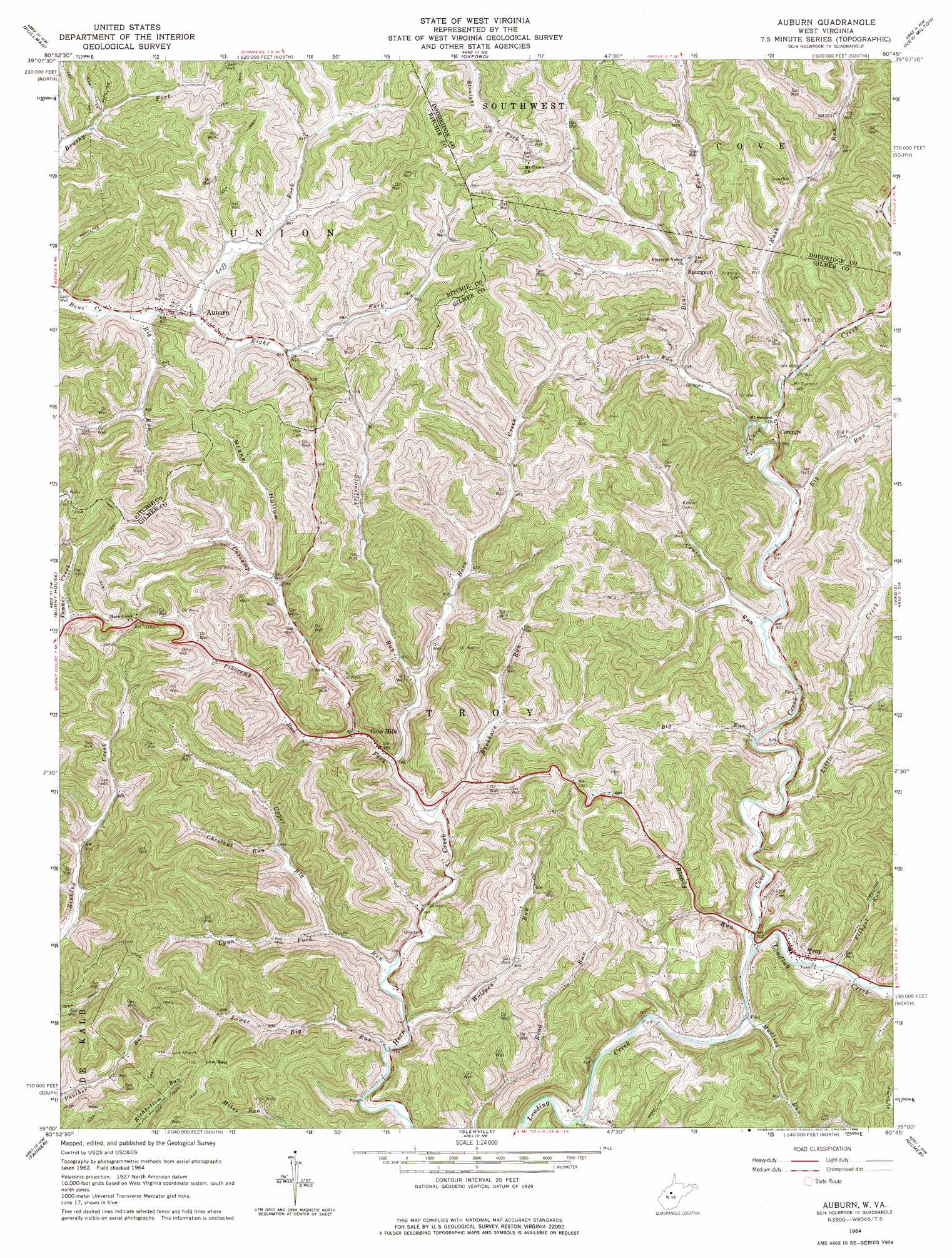
Auburn Topo Map West Virginia
To zoom in, hover over the map of Auburn
USGS Topo Quad 39080a7 - 1:24,000 scale
| Topo Map Name: | Auburn |
| USGS Topo Quad ID: | 39080a7 |
| Print Size: | ca. 21 1/4" wide x 27" high |
| Southeast Coordinates: | 39° N latitude / 80.75° W longitude |
| Map Center Coordinates: | 39.0625° N latitude / 80.8125° W longitude |
| U.S. State: | WV |
| Filename: | o39080a7.jpg |
| Download Map JPG Image: | Auburn topo map 1:24,000 scale |
| Map Type: | Topographic |
| Topo Series: | 7.5´ |
| Map Scale: | 1:24,000 |
| Source of Map Images: | United States Geological Survey (USGS) |
| Alternate Map Versions: |
Auburn WV 1964, updated 1966 Download PDF Buy paper map Auburn WV 1964, updated 1974 Download PDF Buy paper map Auburn WV 2011 Download PDF Buy paper map Auburn WV 2014 Download PDF Buy paper map Auburn WV 2016 Download PDF Buy paper map |
1:24,000 Topo Quads surrounding Auburn
Ellenboro |
Pennsboro |
West Union |
Smithburg |
Salem |
Harrisville |
Pullman |
Oxford |
New Milton |
Big Isaac |
Smithville |
Burnt House |
Auburn |
Vadis |
Camden |
Grantsville |
Tanner |
Glenville |
Gilmer |
Peterson |
Millstone |
Normantown |
Cedarville |
Burnsville |
Orlando |
> Back to 39080a1 at 1:100,000 scale
> Back to 39080a1 at 1:250,000 scale
> Back to U.S. Topo Maps home
Auburn topo map: Gazetteer
Auburn: Gaps
Low Gap elevation 350m 1148′Auburn: Populated Places
Auburn elevation 252m 826′Conings elevation 272m 892′
Coxs Mills elevation 239m 784′
Spurgeon elevation 257m 843′
Troy elevation 229m 751′
Auburn: Post Offices
Auburn Post Office elevation 252m 826′Coxs Mills Post Office elevation 242m 793′
Troy Post Office elevation 229m 751′
Auburn: Streams
Bear Fork elevation 238m 780′Big Run elevation 230m 754′
Big Run elevation 249m 816′
Big Run elevation 237m 777′
Bloody Run elevation 225m 738′
Buckhorn Run elevation 242m 793′
Chestnut Run elevation 263m 862′
Cove Creek elevation 225m 738′
Coxcamp Fork elevation 238m 780′
Crane Run elevation 233m 764′
Ellis Run elevation 223m 731′
Fishpot Run elevation 226m 741′
Left Fork Bone Creek elevation 251m 823′
Lick Run elevation 245m 803′
Little Cove Creek elevation 230m 754′
Lower Big Run elevation 222m 728′
Lynn Fork elevation 237m 777′
Mudlick Run elevation 224m 734′
Pikecamp Run elevation 243m 797′
Right Fork Bone Creek elevation 251m 823′
Rush Run elevation 241m 790′
Stonelick Run elevation 242m 793′
Upper Big Run elevation 227m 744′
Wolfpen Run elevation 225m 738′
Auburn: Valleys
Brake Hollow elevation 260m 853′Auburn digital topo map on disk
Buy this Auburn topo map showing relief, roads, GPS coordinates and other geographical features, as a high-resolution digital map file on DVD:
 map DVD")