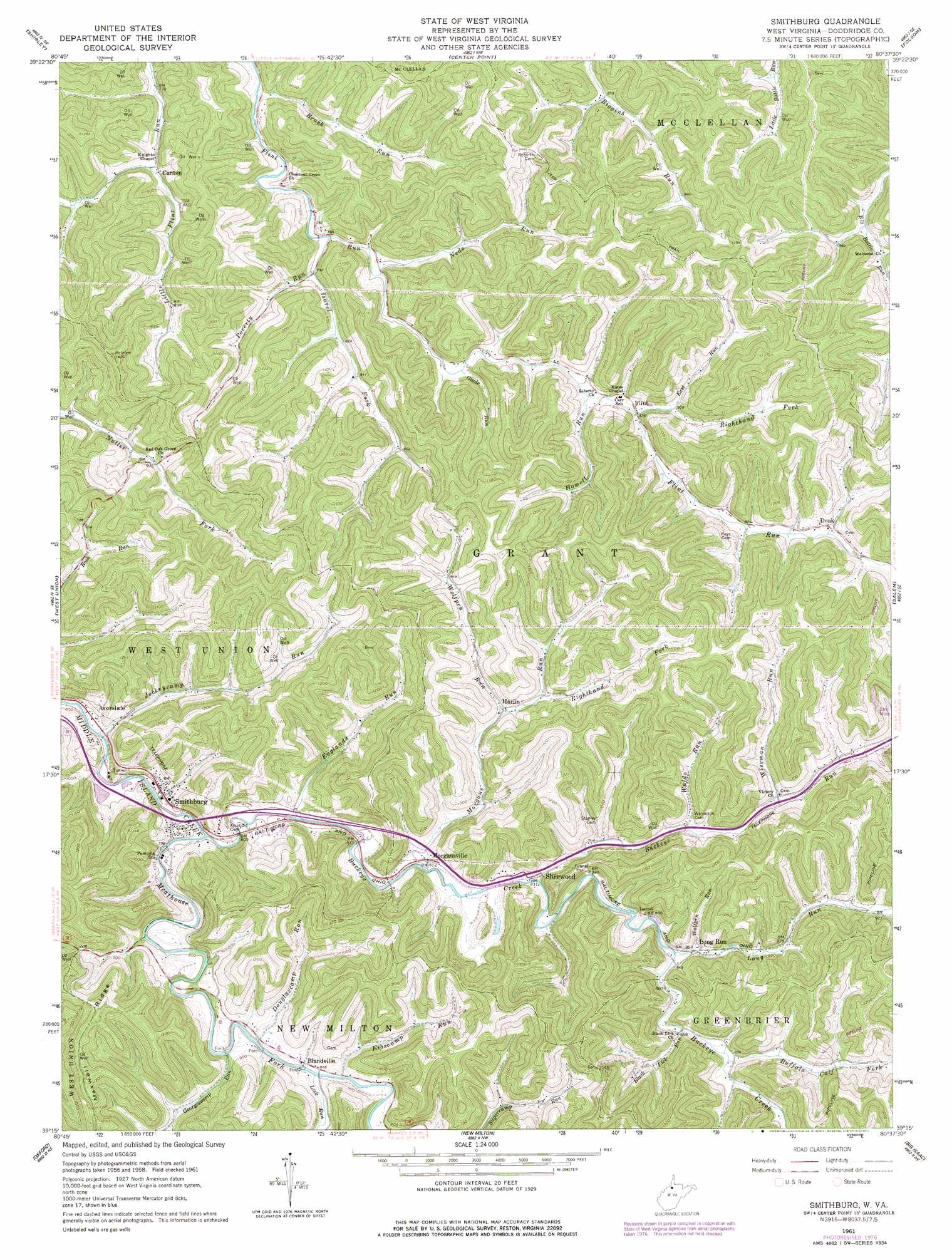
Smithburg Topo Map West Virginia
To zoom in, hover over the map of Smithburg
USGS Topo Quad 39080c6 - 1:24,000 scale
| Topo Map Name: | Smithburg |
| USGS Topo Quad ID: | 39080c6 |
| Print Size: | ca. 21 1/4" wide x 27" high |
| Southeast Coordinates: | 39.25° N latitude / 80.625° W longitude |
| Map Center Coordinates: | 39.3125° N latitude / 80.6875° W longitude |
| U.S. State: | WV |
| Filename: | o39080c6.jpg |
| Download Map JPG Image: | Smithburg topo map 1:24,000 scale |
| Map Type: | Topographic |
| Topo Series: | 7.5´ |
| Map Scale: | 1:24,000 |
| Source of Map Images: | United States Geological Survey (USGS) |
| Alternate Map Versions: |
Smithburg WV 1961, updated 1963 Download PDF Buy paper map Smithburg WV 1961, updated 1977 Download PDF Buy paper map Smithburg WV 2011 Download PDF Buy paper map Smithburg WV 2014 Download PDF Buy paper map Smithburg WV 2016 Download PDF Buy paper map |
1:24,000 Topo Quads surrounding Smithburg
Paden City |
Porters Falls |
Pine Grove |
Big Run |
Glover Gap |
Middlebourne |
Shirley |
Center Point |
Folsom |
Wallace |
Pennsboro |
West Union |
Smithburg |
Salem |
Wolf Summit |
Pullman |
Oxford |
New Milton |
Big Isaac |
West Milford |
Burnt House |
Auburn |
Vadis |
Camden |
Weston |
> Back to 39080a1 at 1:100,000 scale
> Back to 39080a1 at 1:250,000 scale
> Back to U.S. Topo Maps home
Smithburg topo map: Gazetteer
Smithburg: Populated Places
Avondale elevation 240m 787′Big Battle (historical) elevation 268m 879′
Blandville elevation 246m 807′
Canton elevation 245m 803′
Doak elevation 272m 892′
Flint elevation 254m 833′
Harlin elevation 261m 856′
Long Run elevation 260m 853′
Morgansville elevation 249m 816′
Sherwood elevation 250m 820′
Smithburg elevation 244m 800′
Smithburg: Post Offices
Blandville Post Office elevation 250m 820′Smithburg: Ridges
Maxwell Ridge elevation 384m 1259′Smithburg: Streams
Black Lick Run elevation 261m 856′Brush Run elevation 238m 780′
Buckeye Creek elevation 242m 793′
Buckeye Run elevation 246m 807′
Buffalo Calf Fork elevation 262m 859′
Douglascamp Run elevation 245m 803′
East Run elevation 276m 905′
Eibscamp Run elevation 251m 823′
Englands Run elevation 250m 820′
Georgescamp Run elevation 244m 800′
Glade Run elevation 244m 800′
Howell Run elevation 251m 823′
Isarel Fork elevation 236m 774′
Jockeycamp Run elevation 237m 777′
Lick Run elevation 248m 813′
Long Run elevation 257m 843′
Meathouse Fork elevation 242m 793′
Morgans Run elevation 243m 797′
Neds Run elevation 239m 784′
Poverty Run elevation 252m 826′
Righthand Fork East Run elevation 260m 853′
Righthand Fork Morgans Run elevation 269m 882′
Waldo Run elevation 282m 925′
Wiseman Run elevation 267m 875′
Wolfpen Run elevation 260m 853′
Wolfpen Run elevation 259m 849′
Smithburg digital topo map on disk
Buy this Smithburg topo map showing relief, roads, GPS coordinates and other geographical features, as a high-resolution digital map file on DVD:
 map DVD")