Fairmont East Topo Map West Virginia
To zoom in, hover over the map of Fairmont East
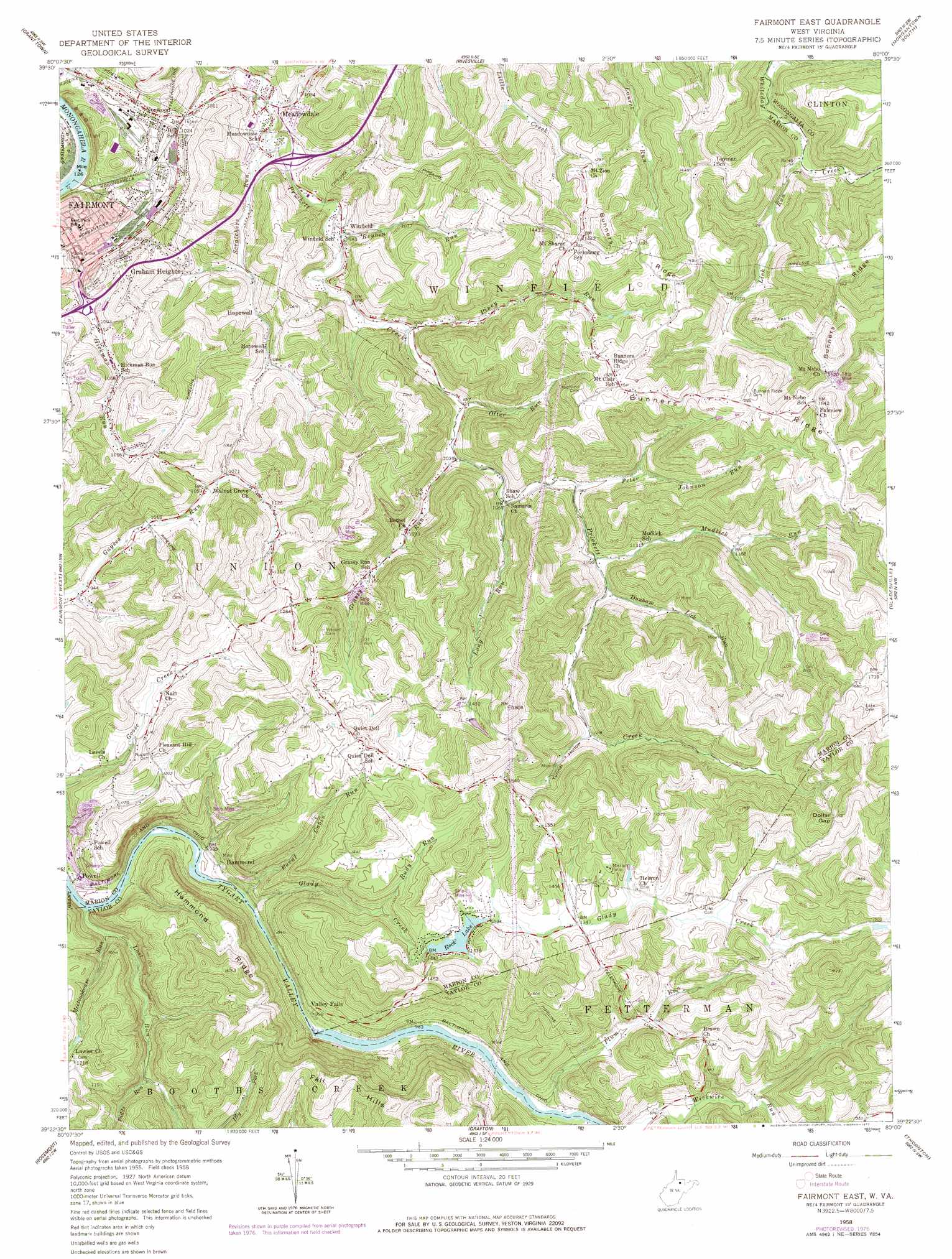
USGS Topo Quad 39080d1 - 1:24,000 scale
| Topo Map Name: | Fairmont East |
| USGS Topo Quad ID: | 39080d1 |
| Print Size: | ca. 21 1/4" wide x 27" high |
| Southeast Coordinates: | 39.375° N latitude / 80° W longitude |
| Map Center Coordinates: | 39.4375° N latitude / 80.0625° W longitude |
| U.S. State: | WV |
| Filename: | o39080d1.jpg |
| Download Map JPG Image: | Fairmont East topo map 1:24,000 scale |
| Map Type: | Topographic |
| Topo Series: | 7.5´ |
| Map Scale: | 1:24,000 |
| Source of Map Images: | United States Geological Survey (USGS) |
| Alternate Map Versions: |
Fairmont East WV 1958, updated 1959 Download PDF Buy paper map Fairmont East WV 1958, updated 1969 Download PDF Buy paper map Fairmont East WV 1958, updated 1977 Download PDF Buy paper map Fairmont East WV 1999, updated 2000 Download PDF Buy paper map Fairmont East WV 2011 Download PDF Buy paper map Fairmont East WV 2014 Download PDF Buy paper map Fairmont East WV 2016 Download PDF Buy paper map |
1:24,000 Topo Quads surrounding Fairmont East
Wadestown |
Blacksville |
Osage |
Morgantown North |
Lake Lynn |
Mannington |
Grant Town |
Rivesville |
Morgantown South |
Masontown |
Shinnston |
Fairmont West |
Fairmont East |
Gladesville |
Newburg |
Clarksburg |
Rosemont |
Grafton |
Thornton |
Fellowsville |
Mount Clare |
Brownton |
Philippi |
Nestorville |
Colebank |
> Back to 39080a1 at 1:100,000 scale
> Back to 39080a1 at 1:250,000 scale
> Back to U.S. Topo Maps home
Fairmont East topo map: Gazetteer
Fairmont East: Crossings
Interchange 137 elevation 310m 1017′Interchange 139 elevation 306m 1003′
Fairmont East: Dams
Rock Lake Dam elevation 417m 1368′Fairmont East: Gaps
Dollar Gap elevation 524m 1719′Fairmont East: Parks
Valley Falls State Park elevation 324m 1062′Fairmont East: Populated Places
Brittain (historical) elevation 314m 1030′Canton elevation 316m 1036′
Forksburg elevation 421m 1381′
Gath (historical) elevation 353m 1158′
Graham Heights elevation 330m 1082′
Hammond elevation 294m 964′
Hebron elevation 416m 1364′
Hopewell elevation 320m 1049′
Meadowdale elevation 283m 928′
Neel (historical) elevation 531m 1742′
Norwood elevation 311m 1020′
Powell elevation 279m 915′
Samaria elevation 326m 1069′
Valley Falls elevation 310m 1017′
Winfield elevation 301m 987′
Winona (historical) elevation 305m 1000′
Fairmont East: Reservoirs
Rock Lake elevation 407m 1335′Fairmont East: Ridges
Bunners Ridge elevation 489m 1604′Hammond Ridge elevation 417m 1368′
Fairmont East: Springs
Meredith Spring elevation 329m 1079′Fairmont East: Streams
Burnt Cabin Run elevation 277m 908′Dunham Lick Run elevation 339m 1112′
Glady Creek elevation 278m 912′
Grassy Run elevation 314m 1030′
Hickman Run elevation 264m 866′
Lick Run elevation 318m 1043′
Long Run elevation 321m 1053′
Lost Run elevation 270m 885′
Meetinghouse Run elevation 272m 892′
Mudlick Run elevation 335m 1099′
Otter Run elevation 311m 1020′
Padds Run elevation 304m 997′
Peter Johnson Run elevation 329m 1079′
Piney Run elevation 305m 1000′
Plum Run elevation 293m 961′
Reuben Run elevation 294m 964′
Rudy Run elevation 364m 1194′
Scratchers Run elevation 282m 925′
Fairmont East: Summits
Kincaid Knob elevation 544m 1784′Fairmont East: Valleys
Tunnel Hollow elevation 368m 1207′Fairmont East digital topo map on disk
Buy this Fairmont East topo map showing relief, roads, GPS coordinates and other geographical features, as a high-resolution digital map file on DVD:
 map DVD")