Shinnston Topo Map West Virginia
To zoom in, hover over the map of Shinnston
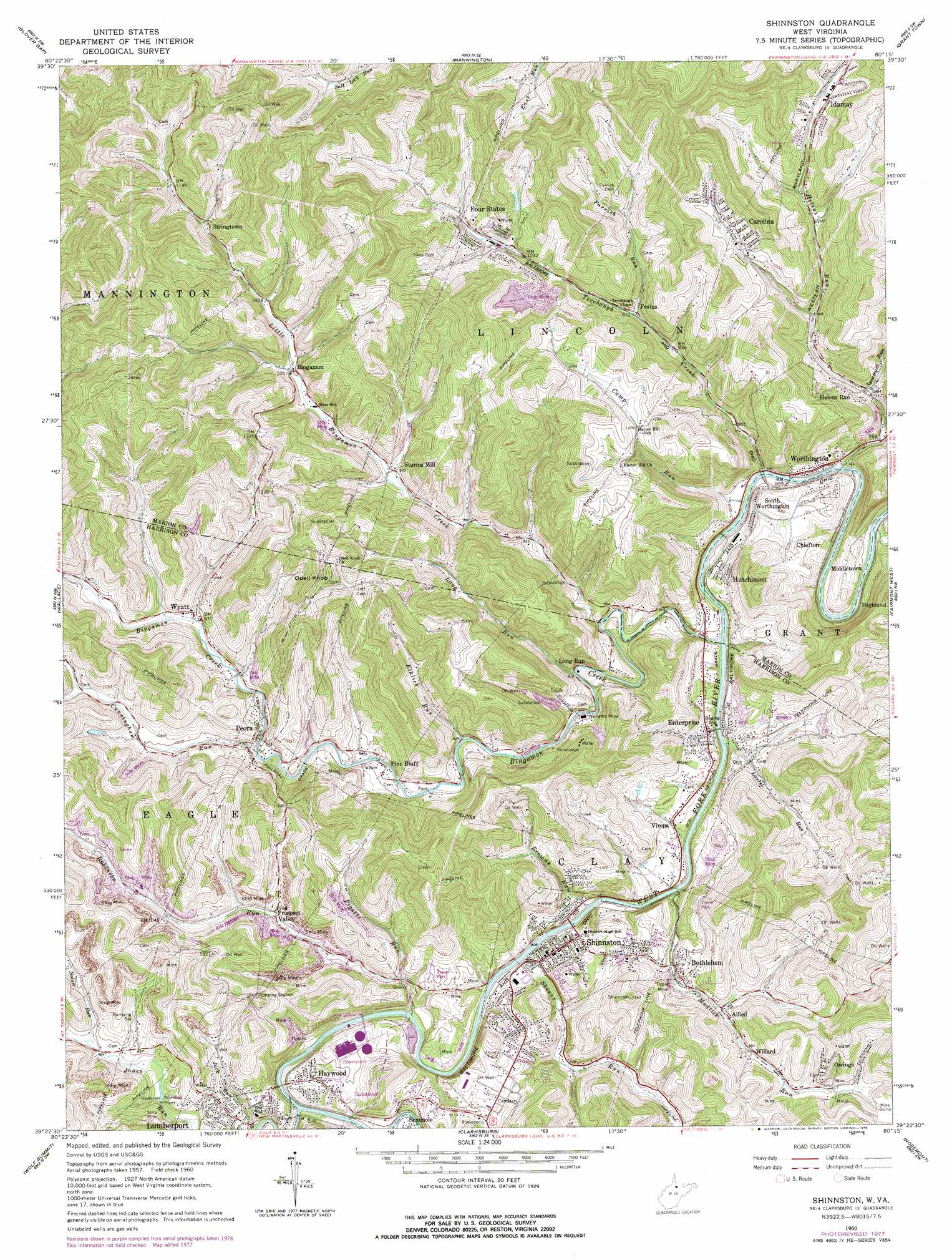
USGS Topo Quad 39080d3 - 1:24,000 scale
| Topo Map Name: | Shinnston |
| USGS Topo Quad ID: | 39080d3 |
| Print Size: | ca. 21 1/4" wide x 27" high |
| Southeast Coordinates: | 39.375° N latitude / 80.25° W longitude |
| Map Center Coordinates: | 39.4375° N latitude / 80.3125° W longitude |
| U.S. State: | WV |
| Filename: | o39080d3.jpg |
| Download Map JPG Image: | Shinnston topo map 1:24,000 scale |
| Map Type: | Topographic |
| Topo Series: | 7.5´ |
| Map Scale: | 1:24,000 |
| Source of Map Images: | United States Geological Survey (USGS) |
| Alternate Map Versions: |
Shinnston WV 1960, updated 1962 Download PDF Buy paper map Shinnston WV 1960, updated 1970 Download PDF Buy paper map Shinnston WV 1960, updated 1978 Download PDF Buy paper map Shinnston WV 2011 Download PDF Buy paper map Shinnston WV 2014 Download PDF Buy paper map Shinnston WV 2016 Download PDF Buy paper map |
1:24,000 Topo Quads surrounding Shinnston
Littleton |
Hundred |
Wadestown |
Blacksville |
Osage |
Big Run |
Glover Gap |
Mannington |
Grant Town |
Rivesville |
Folsom |
Wallace |
Shinnston |
Fairmont West |
Fairmont East |
Salem |
Wolf Summit |
Clarksburg |
Rosemont |
Grafton |
Big Isaac |
West Milford |
Mount Clare |
Brownton |
Philippi |
> Back to 39080a1 at 1:100,000 scale
> Back to 39080a1 at 1:250,000 scale
> Back to U.S. Topo Maps home
Shinnston topo map: Gazetteer
Shinnston: Airports
Wade F Maley Field elevation 294m 964′Shinnston: Dams
Four States Slurry Impoundment Dam elevation 442m 1450′Four States Water Supply Dam elevation 344m 1128′
Lower Coal Lick A M D Facility Dam elevation 332m 1089′
Mary Rose Salernumber Lake Dam elevation 322m 1056′
Nutter Run Impoundment Dam elevation 321m 1053′
Robinson Run Mine Number 95 Dam elevation 323m 1059′
Shinnston: Mines
Williams Mine elevation 285m 935′Shinnston: Populated Places
Allied elevation 292m 958′Bethlehem elevation 297m 974′
Bingamon elevation 304m 997′
Carolina elevation 361m 1184′
Chiefton elevation 269m 882′
Dixie elevation 295m 967′
Enterprise elevation 290m 951′
Festus elevation 296m 971′
Four States elevation 320m 1049′
Haywood elevation 311m 1020′
Helens Run elevation 276m 905′
Highland elevation 304m 997′
Hutchinson elevation 292m 958′
Idamay elevation 359m 1177′
Long Run elevation 277m 908′
Oak Grove (historical) elevation 386m 1266′
Owings elevation 320m 1049′
Peora elevation 294m 964′
Pine Bluff elevation 290m 951′
Prospect Valley elevation 317m 1040′
Seminole elevation 306m 1003′
Shinnston elevation 283m 928′
South Worthington elevation 281m 921′
Stringtown elevation 327m 1072′
Sturms Mill elevation 304m 997′
Viropa elevation 294m 964′
Willard elevation 301m 987′
Worthington elevation 281m 921′
Wyatt elevation 301m 987′
Shinnston: Post Offices
Carolina Post Office elevation 359m 1177′Enterprise Post Office elevation 283m 928′
Four States Post Office elevation 324m 1062′
Haywood Post Office elevation 304m 997′
Idamay Post Office elevation 357m 1171′
Wyatt Post Office elevation 294m 964′
Shinnston: Reservoirs
Number 98 Slurry Pond elevation 321m 1053′Williams Mine A M D Pond elevation 332m 1089′
Shinnston: Springs
Fisher Foundry Spring elevation 291m 954′Mrs Catherine Haas Spring elevation 309m 1013′
Shinnston: Streams
Bingamon Creek elevation 266m 872′Browns Run elevation 268m 879′
Camp Run elevation 265m 869′
Coons Run elevation 263m 862′
Cunningham Run elevation 294m 964′
Elklick Run elevation 283m 928′
Helens Run elevation 265m 869′
Jack Run elevation 273m 895′
Laurel Run elevation 267m 875′
Little Bingamon Creek elevation 272m 892′
Long Run elevation 278m 912′
Mudlick Run elevation 275m 902′
Nolan Run elevation 295m 967′
Parrish Run elevation 294m 964′
Pigotts Run elevation 279m 915′
Robinson Run elevation 272m 892′
Shinns Run elevation 274m 898′
Sycamore Run elevation 281m 921′
Tenmile Creek elevation 272m 892′
Tevebaugh Creek elevation 265m 869′
Shinnston: Summits
Odell Knob elevation 466m 1528′Shinnston digital topo map on disk
Buy this Shinnston topo map showing relief, roads, GPS coordinates and other geographical features, as a high-resolution digital map file on DVD:
 map DVD")