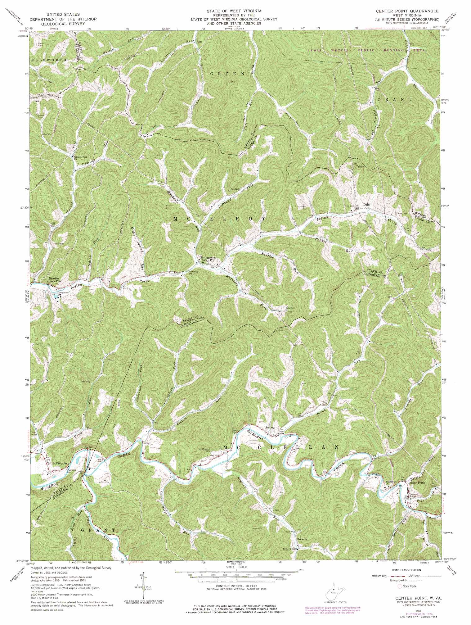
Center Point Topo Map West Virginia
To zoom in, hover over the map of Center Point
USGS Topo Quad 39080d6 - 1:24,000 scale
| Topo Map Name: | Center Point |
| USGS Topo Quad ID: | 39080d6 |
| Print Size: | ca. 21 1/4" wide x 27" high |
| Southeast Coordinates: | 39.375° N latitude / 80.625° W longitude |
| Map Center Coordinates: | 39.4375° N latitude / 80.6875° W longitude |
| U.S. State: | WV |
| Filename: | o39080d6.jpg |
| Download Map JPG Image: | Center Point topo map 1:24,000 scale |
| Map Type: | Topographic |
| Topo Series: | 7.5´ |
| Map Scale: | 1:24,000 |
| Source of Map Images: | United States Geological Survey (USGS) |
| Alternate Map Versions: |
Center Point WV 1961, updated 1964 Download PDF Buy paper map Cedar Point WV 1961, updated 1977 Download PDF Buy paper map Center Point WV 1961, updated 1977 Download PDF Buy paper map Center Point WV 1976, updated 1979 Download PDF Buy paper map Center Point WV 2011 Download PDF Buy paper map Center Point WV 2014 Download PDF Buy paper map Center Point WV 2016 Download PDF Buy paper map |
1:24,000 Topo Quads surrounding Center Point
Round Bottom |
New Martinsville |
Wileyville |
Littleton |
Hundred |
Paden City |
Porters Falls |
Pine Grove |
Big Run |
Glover Gap |
Middlebourne |
Shirley |
Center Point |
Folsom |
Wallace |
Pennsboro |
West Union |
Smithburg |
Salem |
Wolf Summit |
Pullman |
Oxford |
New Milton |
Big Isaac |
West Milford |
> Back to 39080a1 at 1:100,000 scale
> Back to 39080a1 at 1:250,000 scale
> Back to U.S. Topo Maps home
Center Point topo map: Gazetteer
Center Point: Bridges
Center Point Covered Bridge elevation 238m 780′Center Point: Populated Places
Ashley elevation 245m 803′Braden elevation 234m 767′
Center Point elevation 241m 790′
Dale elevation 275m 902′
Link elevation 367m 1204′
Little Pittsburg elevation 253m 830′
Roberts elevation 255m 836′
Ross elevation 260m 853′
Stringtown elevation 247m 810′
Center Point: Post Offices
Alvy Post Office elevation 247m 810′Center Point Post Office elevation 243m 797′
Lima Post Office elevation 234m 767′
Center Point: Streams
Anderson Fork elevation 235m 770′Beartree Run elevation 256m 839′
Big Battle Run elevation 241m 790′
Bonelick Run elevation 252m 826′
Broad Run elevation 232m 761′
Bunker Run elevation 266m 872′
Cale Run elevation 274m 898′
Campbell Run elevation 258m 846′
Davis Run elevation 221m 725′
Elklick Run elevation 225m 738′
Flint Run elevation 224m 734′
Franks Run elevation 238m 780′
Grass Spring Run elevation 241m 790′
Indian Run elevation 235m 770′
Laughery Fork elevation 229m 751′
Lefthand Fork Stackpole Run elevation 251m 823′
Little Battle Run elevation 241m 790′
Little Flint Run elevation 226m 741′
McIntyre Fork elevation 246m 807′
Pike Fork elevation 237m 777′
Ralphs Run elevation 226m 741′
Riggins Run elevation 228m 748′
Robinson Fork elevation 238m 780′
Stackpole Run elevation 244m 800′
Sunfish Run elevation 252m 826′
Talkington Fork elevation 237m 777′
Walnut Fork elevation 230m 754′
Center Point digital topo map on disk
Buy this Center Point topo map showing relief, roads, GPS coordinates and other geographical features, as a high-resolution digital map file on DVD:
 map DVD")