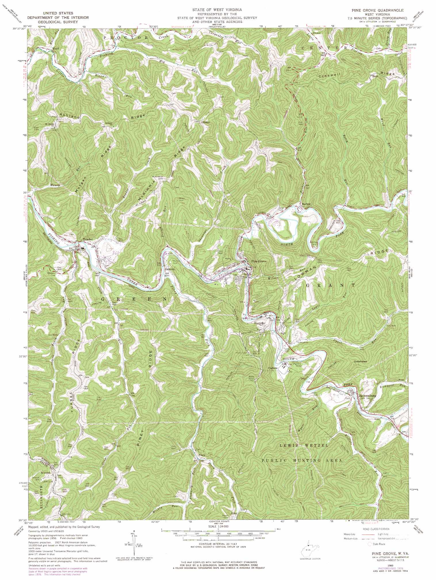
Pine Grove Topo Map West Virginia
To zoom in, hover over the map of Pine Grove
USGS Topo Quad 39080e6 - 1:24,000 scale
| Topo Map Name: | Pine Grove |
| USGS Topo Quad ID: | 39080e6 |
| Print Size: | ca. 21 1/4" wide x 27" high |
| Southeast Coordinates: | 39.5° N latitude / 80.625° W longitude |
| Map Center Coordinates: | 39.5625° N latitude / 80.6875° W longitude |
| U.S. State: | WV |
| Filename: | o39080e6.jpg |
| Download Map JPG Image: | Pine Grove topo map 1:24,000 scale |
| Map Type: | Topographic |
| Topo Series: | 7.5´ |
| Map Scale: | 1:24,000 |
| Source of Map Images: | United States Geological Survey (USGS) |
| Alternate Map Versions: |
Pine Grove WV 1960, updated 1962 Download PDF Buy paper map Pine Grove WV 1960, updated 1977 Download PDF Buy paper map Pine Grove WV 1976, updated 1979 Download PDF Buy paper map Pine Grove WV 2011 Download PDF Buy paper map Pine Grove WV 2014 Download PDF Buy paper map Pine Grove WV 2016 Download PDF Buy paper map |
1:24,000 Topo Quads surrounding Pine Grove
Cameron |
Powhatan Point |
Glen Easton |
Cameron |
New Freeport |
Round Bottom |
New Martinsville |
Wileyville |
Littleton |
Hundred |
Paden City |
Porters Falls |
Pine Grove |
Big Run |
Glover Gap |
Middlebourne |
Shirley |
Center Point |
Folsom |
Wallace |
Pennsboro |
West Union |
Smithburg |
Salem |
Wolf Summit |
> Back to 39080e1 at 1:100,000 scale
> Back to 39080a1 at 1:250,000 scale
> Back to U.S. Topo Maps home
Pine Grove topo map: Gazetteer
Pine Grove: Parks
Lewis Wetzel Wildlife Management Area elevation 433m 1420′Pine Grove: Populated Places
Allister elevation 407m 1335′Atwood elevation 375m 1230′
Barker elevation 224m 734′
Carbide elevation 223m 731′
Galmish elevation 211m 692′
Halls Mills elevation 231m 757′
Hastings elevation 230m 754′
Hoyt elevation 432m 1417′
Jacksonburg elevation 228m 748′
King elevation 256m 839′
Mand elevation 221m 725′
Onie (historical) elevation 275m 902′
Pine Grove elevation 218m 715′
Piney elevation 241m 790′
Reader elevation 211m 692′
Shenango (historical) elevation 257m 843′
Suter (historical) elevation 258m 846′
Pine Grove: Post Offices
Jacksonburg Post Office elevation 227m 744′Pine Grove: Ridges
Ashland Ridge elevation 432m 1417′Furbee Ridge elevation 410m 1345′
McKimmie Ridge elevation 444m 1456′
Morgan Ridge elevation 387m 1269′
Piney Ridge elevation 406m 1332′
Pine Grove: Streams
Barker Run elevation 220m 721′Betsy Run elevation 233m 764′
Blenn Run elevation 229m 751′
Brush Run elevation 205m 672′
Buffalo Run elevation 225m 738′
Crow Run elevation 209m 685′
Fluharty Fork elevation 239m 784′
Hog Run elevation 227m 744′
Honey Run elevation 270m 885′
Long Run elevation 218m 715′
Lower Run elevation 218m 715′
Maud Run elevation 232m 761′
Money Run elevation 203m 666′
North Fork Fishing Creek elevation 212m 695′
Pine Run elevation 230m 754′
Piney Fork elevation 208m 682′
Reader Creek elevation 206m 675′
Richwood Run elevation 226m 741′
Rush Run elevation 220m 721′
Shenango Creek elevation 210m 688′
South Fork Fishing Creek elevation 212m 695′
Trough Run elevation 209m 685′
Upper Run elevation 220m 721′
Weekly Run elevation 248m 813′
Wilson Run elevation 212m 695′
Wyatt Run elevation 225m 738′
Pine Grove: Summits
Owlshead elevation 442m 1450′Pine Grove digital topo map on disk
Buy this Pine Grove topo map showing relief, roads, GPS coordinates and other geographical features, as a high-resolution digital map file on DVD:
 map DVD")