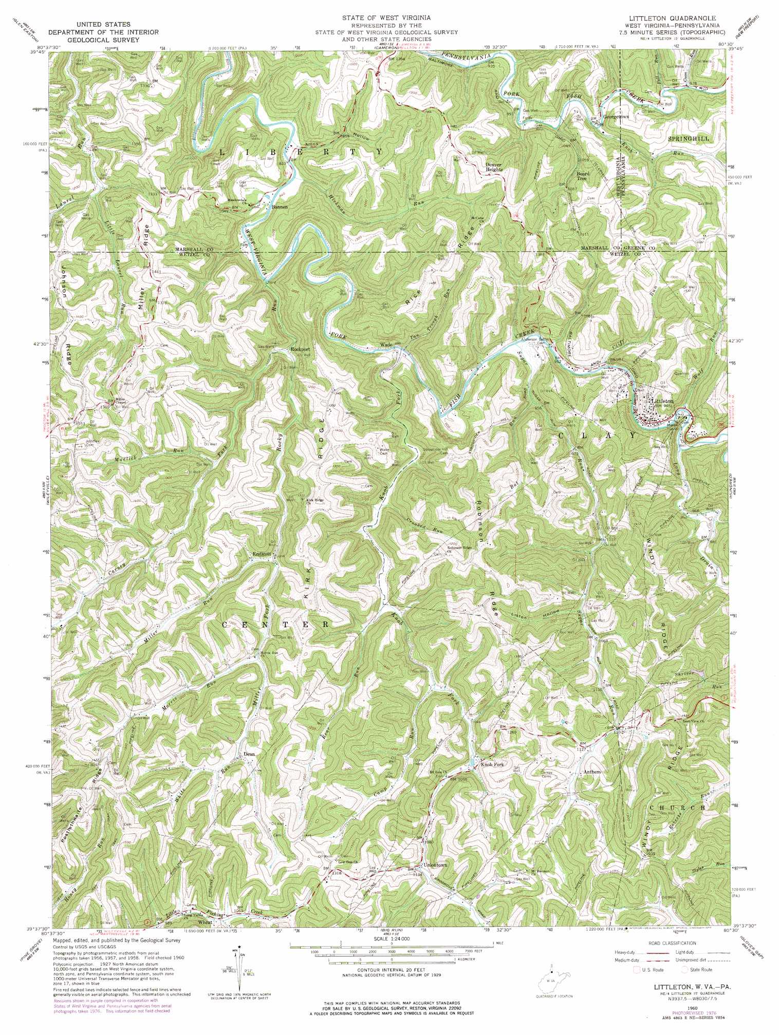
Littleton Topo Map West Virginia
To zoom in, hover over the map of Littleton
USGS Topo Quad 39080f5 - 1:24,000 scale
| Topo Map Name: | Littleton |
| USGS Topo Quad ID: | 39080f5 |
| Print Size: | ca. 21 1/4" wide x 27" high |
| Southeast Coordinates: | 39.625° N latitude / 80.5° W longitude |
| Map Center Coordinates: | 39.6875° N latitude / 80.5625° W longitude |
| U.S. States: | WV, PA |
| Filename: | o39080f5.jpg |
| Download Map JPG Image: | Littleton topo map 1:24,000 scale |
| Map Type: | Topographic |
| Topo Series: | 7.5´ |
| Map Scale: | 1:24,000 |
| Source of Map Images: | United States Geological Survey (USGS) |
| Alternate Map Versions: |
Littleton WV 1960, updated 1962 Download PDF Buy paper map Littleton WV 1960, updated 1977 Download PDF Buy paper map Littleton WV 1998, updated 2000 Download PDF Buy paper map Littleton WV 2011 Download PDF Buy paper map Littleton WV 2014 Download PDF Buy paper map Littleton WV 2016 Download PDF Buy paper map |
1:24,000 Topo Quads surrounding Littleton
Businessburg |
Moundsville |
Majorsville |
Wind Ridge |
Rogersville |
Powhatan Point |
Glen Easton |
Cameron |
New Freeport |
Holbrook |
New Martinsville |
Wileyville |
Littleton |
Hundred |
Wadestown |
Porters Falls |
Pine Grove |
Big Run |
Glover Gap |
Mannington |
Shirley |
Center Point |
Folsom |
Wallace |
Shinnston |
> Back to 39080e1 at 1:100,000 scale
> Back to 39080a1 at 1:250,000 scale
> Back to U.S. Topo Maps home
Littleton topo map: Gazetteer
Littleton: Populated Places
Anthem elevation 348m 1141′Bannen elevation 272m 892′
Dean elevation 337m 1105′
Denver Heights elevation 451m 1479′
Endicott elevation 306m 1003′
Georgetown elevation 293m 961′
Knob Fork elevation 320m 1049′
Littleton elevation 282m 925′
Rockport elevation 272m 892′
Uniontown elevation 336m 1102′
Wade elevation 271m 889′
Wheat elevation 317m 1040′
Littleton: Ridges
Johnson Ridge elevation 421m 1381′Kirk Ridge elevation 440m 1443′
Miller Ridge elevation 449m 1473′
Rice Ridge elevation 430m 1410′
Robinson Ridge elevation 442m 1450′
Windy Ridge elevation 455m 1492′
Littleton: Streams
Bat Run elevation 307m 1007′Bear Run elevation 323m 1059′
Camp Run elevation 312m 1023′
Carney Fork elevation 273m 895′
Cliff Run elevation 282m 925′
Coon Run elevation 298m 977′
Crooked Run elevation 293m 961′
Fall Run elevation 297m 974′
Hickman Run elevation 251m 823′
Isaac Run elevation 321m 1053′
Knob Fork elevation 272m 892′
Knob Run elevation 290m 951′
Knob Run elevation 308m 1010′
Little Laurel Run elevation 295m 967′
Long Drain elevation 312m 1023′
Miller Fork elevation 313m 1026′
Miller Run elevation 313m 1026′
Morris Run elevation 322m 1056′
Mudlick Run elevation 302m 990′
Rocky Run elevation 278m 912′
Stottlemire Run elevation 307m 1007′
Sugar Run elevation 275m 902′
Tan Trough Run elevation 269m 882′
White Run elevation 336m 1102′
Wolf Run elevation 353m 1158′
Wolf Run elevation 283m 928′
Littleton: Tunnels
Board Tree Tunnel elevation 393m 1289′Martin Tunnel elevation 323m 1059′
Littleton: Valleys
Amos Hollow elevation 256m 839′Liston Hollow elevation 321m 1053′
Littleton digital topo map on disk
Buy this Littleton topo map showing relief, roads, GPS coordinates and other geographical features, as a high-resolution digital map file on DVD:
 map DVD")