Glen Easton Topo Map West Virginia
To zoom in, hover over the map of Glen Easton
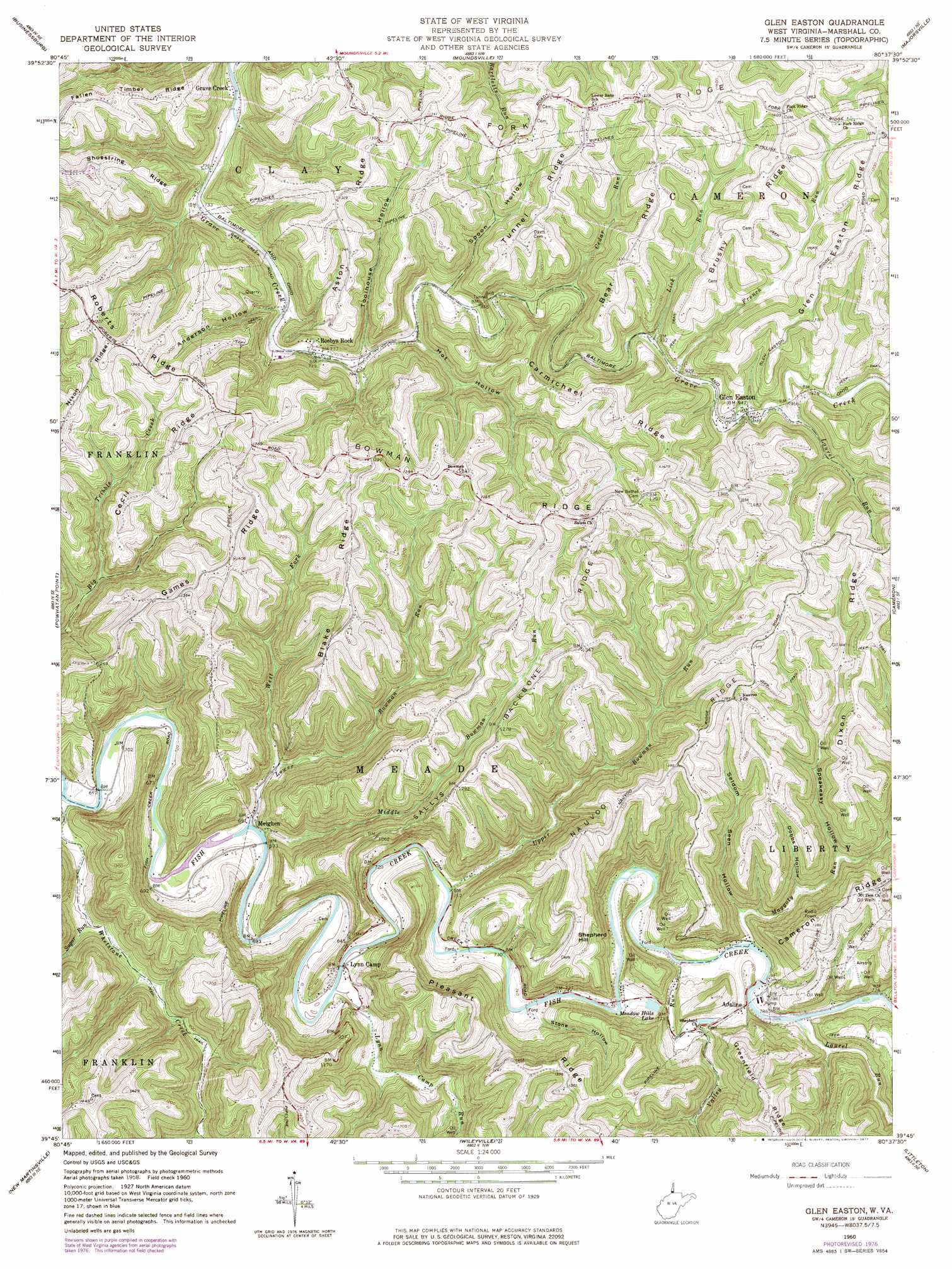
USGS Topo Quad 39080g6 - 1:24,000 scale
| Topo Map Name: | Glen Easton |
| USGS Topo Quad ID: | 39080g6 |
| Print Size: | ca. 21 1/4" wide x 27" high |
| Southeast Coordinates: | 39.75° N latitude / 80.625° W longitude |
| Map Center Coordinates: | 39.8125° N latitude / 80.6875° W longitude |
| U.S. State: | WV |
| Filename: | o39080g6.jpg |
| Download Map JPG Image: | Glen Easton topo map 1:24,000 scale |
| Map Type: | Topographic |
| Topo Series: | 7.5´ |
| Map Scale: | 1:24,000 |
| Source of Map Images: | United States Geological Survey (USGS) |
| Alternate Map Versions: |
Glen Easton WV 1960, updated 1961 Download PDF Buy paper map Glen Easton WV 1960, updated 1973 Download PDF Buy paper map Glen Easton WV 1960, updated 1977 Download PDF Buy paper map Glen Easton WV 2011 Download PDF Buy paper map Glen Easton WV 2014 Download PDF Buy paper map Glen Easton WV 2016 Download PDF Buy paper map |
1:24,000 Topo Quads surrounding Glen Easton
St Clairsville |
Lansing |
Wheeling |
Valley Grove |
Claysville |
Armstrongs Mills |
Businessburg |
Moundsville |
Majorsville |
Wind Ridge |
Cameron |
Powhatan Point |
Glen Easton |
Cameron |
New Freeport |
Round Bottom |
New Martinsville |
Wileyville |
Littleton |
Hundred |
Paden City |
Porters Falls |
Pine Grove |
Big Run |
Glover Gap |
> Back to 39080e1 at 1:100,000 scale
> Back to 39080a1 at 1:250,000 scale
> Back to U.S. Topo Maps home
Glen Easton topo map: Gazetteer
Glen Easton: Bridges
Shephards Bridge elevation 223m 731′Glen Easton: Mines
McElroy Mine elevation 368m 1207′Glen Easton: Populated Places
Adaline elevation 240m 787′Glen Easton elevation 288m 944′
Grave Creek elevation 213m 698′
Lynn Camp elevation 217m 711′
Meighen elevation 210m 688′
Rosbys Rock elevation 237m 777′
Teutonic (historical) elevation 417m 1368′
Glen Easton: Reservoirs
Meadow Hills Lake elevation 226m 741′Glen Easton: Ridges
Aston Ridge elevation 380m 1246′Bear Ridge elevation 411m 1348′
Blake Ridge elevation 413m 1354′
Bowman Ridge elevation 422m 1384′
Brushy Ridge elevation 422m 1384′
Carmichael Ridge elevation 395m 1295′
Cecil Ridge elevation 406m 1332′
Dixon Ridge elevation 414m 1358′
Fallen Timber Ridge elevation 376m 1233′
Fork Ridge elevation 435m 1427′
Games Ridge elevation 423m 1387′
Glen Easton Ridge elevation 424m 1391′
Nauvoo Ridge elevation 424m 1391′
Pleasant Ridge elevation 423m 1387′
Sallys Backbone Ridge elevation 412m 1351′
Shoestring Ridge elevation 374m 1227′
Tunnel Ridge elevation 397m 1302′
Glen Easton: Springs
Anthony Mysliwiec Spring elevation 409m 1341′Dorothy Wetzel Spring elevation 372m 1220′
Lowell Ryan Spring elevation 364m 1194′
Martin Hill Spring elevation 375m 1230′
Paul Adams Spring elevation 422m 1384′
Roy Rine Spring elevation 418m 1371′
William Standiford Spring elevation 380m 1246′
Glen Easton: Streams
Big Run elevation 231m 757′Blair Run elevation 399m 1309′
Burch Run elevation 298m 977′
Cedar Run elevation 264m 866′
French Run elevation 282m 925′
Laurel Run elevation 292m 958′
Laurel Run elevation 229m 751′
Left Fork Maggoty Run elevation 270m 885′
Lick Run elevation 280m 918′
Lower Bowman Run elevation 207m 679′
Lynn Camp Run elevation 213m 698′
Maggoty Run elevation 228m 748′
Middle Bowman Run elevation 208m 682′
Rocky Fork elevation 245m 803′
Sugar Run elevation 213m 698′
Upper Bowman Run elevation 215m 705′
Valley Run elevation 228m 748′
West Fork Lower Bowman Run elevation 220m 721′
Whetstone Creek elevation 198m 649′
Glen Easton: Summits
Shepherd Hill elevation 383m 1256′Glen Easton: Valleys
Anderson Hollow elevation 236m 774′Dobbs Hollow elevation 257m 843′
Hot Hollow elevation 245m 803′
Seldom Seen Hollow elevation 240m 787′
Speakeasy Hollow elevation 261m 856′
Spoon Hollow elevation 253m 830′
Stone Hollow elevation 224m 734′
Toolhouse Hollow elevation 240m 787′
Glen Easton digital topo map on disk
Buy this Glen Easton topo map showing relief, roads, GPS coordinates and other geographical features, as a high-resolution digital map file on DVD:
 map DVD")