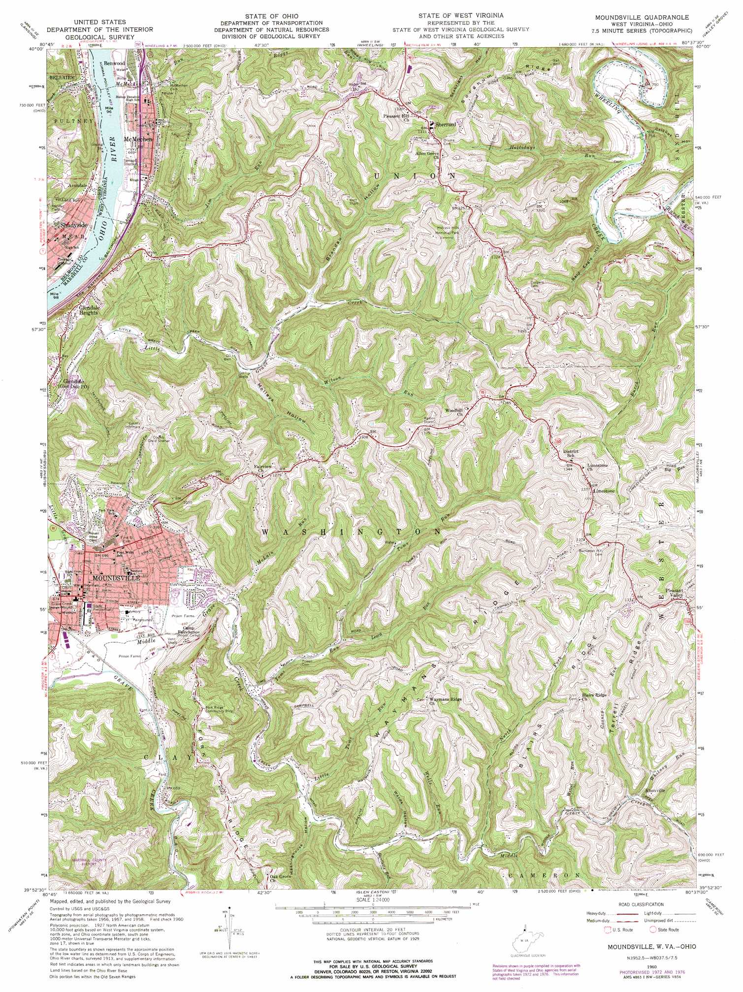
Moundsville Topo Map West Virginia
To zoom in, hover over the map of Moundsville
USGS Topo Quad 39080h6 - 1:24,000 scale
| Topo Map Name: | Moundsville |
| USGS Topo Quad ID: | 39080h6 |
| Print Size: | ca. 21 1/4" wide x 27" high |
| Southeast Coordinates: | 39.875° N latitude / 80.625° W longitude |
| Map Center Coordinates: | 39.9375° N latitude / 80.6875° W longitude |
| U.S. States: | WV, OH |
| Filename: | o39080h6.jpg |
| Download Map JPG Image: | Moundsville topo map 1:24,000 scale |
| Map Type: | Topographic |
| Topo Series: | 7.5´ |
| Map Scale: | 1:24,000 |
| Source of Map Images: | United States Geological Survey (USGS) |
| Alternate Map Versions: |
Moundsville WV 1960, updated 1961 Download PDF Buy paper map Moundsville WV 1960, updated 1966 Download PDF Buy paper map Moundsville WV 1960, updated 1973 Download PDF Buy paper map Moundsville WV 1960, updated 1977 Download PDF Buy paper map Moundsville WV 1997, updated 1999 Download PDF Buy paper map Moundsville WV 2011 Download PDF Buy paper map Moundsville WV 2014 Download PDF Buy paper map Moundsville WV 2016 Download PDF Buy paper map |
1:24,000 Topo Quads surrounding Moundsville
Harrisville |
Dillonvale |
Tiltonsville |
Bethany |
West Middletown |
St Clairsville |
Lansing |
Wheeling |
Valley Grove |
Claysville |
Armstrongs Mills |
Businessburg |
Moundsville |
Majorsville |
Wind Ridge |
Cameron |
Powhatan Point |
Glen Easton |
Cameron |
New Freeport |
Round Bottom |
New Martinsville |
Wileyville |
Littleton |
Hundred |
> Back to 39080e1 at 1:100,000 scale
> Back to 39080a1 at 1:250,000 scale
> Back to U.S. Topo Maps home
Moundsville topo map: Gazetteer
Moundsville: Airports
Marshall County Airport elevation 368m 1207′Moundsville: Bars
Riley Run Bar elevation 193m 633′Moundsville: Dams
Lock and Dam Number 13 (historical) elevation 193m 633′Moundsville: Gaps
The Narrows elevation 193m 633′Moundsville: Parks
Burches Run Wildlife Management Area elevation 243m 797′East End Park elevation 205m 672′
Marshall County Fairgrounds elevation 196m 643′
McMechen City Park and Pool elevation 200m 656′
Methodist Park elevation 228m 748′
Saint Jude Park elevation 204m 669′
Valley Fork City Park elevation 202m 662′
Moundsville: Populated Places
Avondale elevation 206m 675′Glendale Heights elevation 323m 1059′
Knoxville elevation 302m 990′
Limestone elevation 420m 1377′
McMechen elevation 207m 679′
Moundsville elevation 212m 695′
Pleasant Valley elevation 398m 1305′
Sherrard elevation 396m 1299′
Moundsville: Post Offices
McMechen Post Office elevation 215m 705′Moundsville Post Office elevation 211m 692′
Shadyside Post Office elevation 209m 685′
Moundsville: Ridges
Blairs Ridge elevation 385m 1263′Sorghum Ridge elevation 393m 1289′
Terrell Ridge elevation 408m 1338′
Waymans Ridge elevation 428m 1404′
Moundsville: Springs
Charles Hoskins Spring elevation 377m 1236′Daniel Rogerson Spring elevation 364m 1194′
Daniel Rogerson Spring elevation 341m 1118′
Donald L Garrison Spring elevation 367m 1204′
George Cunningham Spring elevation 346m 1135′
Harold R Franklin Spring elevation 364m 1194′
Ivan Dean Spring elevation 378m 1240′
Ivan Dean Spring elevation 361m 1184′
Ivan McCombs Spring elevation 365m 1197′
Ivan McCombs Spring elevation 341m 1118′
Ivan McCombs Spring elevation 364m 1194′
Ivan McCombs Spring elevation 369m 1210′
Ivan McCombs Spring elevation 318m 1043′
Ivan McCombs Spring elevation 374m 1227′
John Tyler Spring elevation 392m 1286′
Lawrence Brown Spring elevation 349m 1145′
Morton Marsh Spring elevation 356m 1167′
Mrs Riggs Spring elevation 361m 1184′
Oscar T Magers Spring elevation 361m 1184′
Prabhupada Spring elevation 359m 1177′
Robert Black Spring elevation 380m 1246′
Roland Mason Spring elevation 380m 1246′
Thompson Spring elevation 211m 692′
Wayne Francis Spring elevation 391m 1282′
Wayne Francis Spring elevation 387m 1269′
Wayne Francis Spring elevation 401m 1315′
William K Heath Spring elevation 389m 1276′
Moundsville: Streams
Bartletts Run elevation 236m 774′Gosney Run elevation 298m 977′
Hollidays Run elevation 229m 751′
Jim Run elevation 193m 633′
Leach Run elevation 230m 754′
Little Toms Run elevation 223m 731′
McLain Run elevation 203m 666′
McMeckens Run elevation 193m 633′
Middle Grave Creek elevation 191m 626′
North Fork Middle Grave Creek elevation 257m 843′
Parrs Run elevation 193m 633′
Pinch Run elevation 192m 629′
Toms Run elevation 210m 688′
Wells Run elevation 246m 807′
Wetzel Run elevation 294m 964′
Whitney Run elevation 294m 964′
Wilson Run elevation 262m 859′
Moundsville: Summits
Grave Creek Indian Mound elevation 219m 718′Moundsville: Valleys
Bald Eagle Hollow elevation 235m 770′Brandau Hollow elevation 277m 908′
Cricket Hollow elevation 242m 793′
Meetinghouse Hollow elevation 230m 754′
Molleys Hollow elevation 241m 790′
Wards Hollow elevation 243m 797′
Moundsville digital topo map on disk
Buy this Moundsville topo map showing relief, roads, GPS coordinates and other geographical features, as a high-resolution digital map file on DVD:
 map DVD")