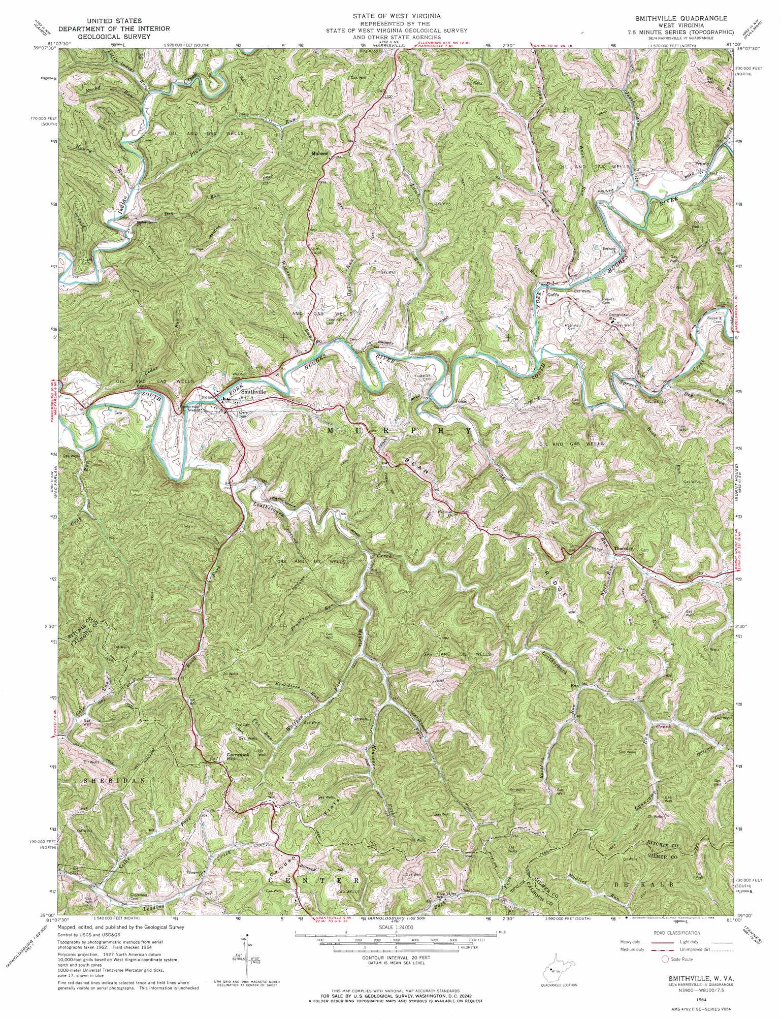
Smithville Topo Map West Virginia
To zoom in, hover over the map of Smithville
USGS Topo Quad 39081a1 - 1:24,000 scale
| Topo Map Name: | Smithville |
| USGS Topo Quad ID: | 39081a1 |
| Print Size: | ca. 21 1/4" wide x 27" high |
| Southeast Coordinates: | 39° N latitude / 81° W longitude |
| Map Center Coordinates: | 39.0625° N latitude / 81.0625° W longitude |
| U.S. State: | WV |
| Filename: | o39081a1.jpg |
| Download Map JPG Image: | Smithville topo map 1:24,000 scale |
| Map Type: | Topographic |
| Topo Series: | 7.5´ |
| Map Scale: | 1:24,000 |
| Source of Map Images: | United States Geological Survey (USGS) |
| Alternate Map Versions: |
Smithville WV 1964, updated 1966 Download PDF Buy paper map Smithville WV 2010 Download PDF Buy paper map Smithville WV 2014 Download PDF Buy paper map Smithville WV 2016 Download PDF Buy paper map |
1:24,000 Topo Quads surrounding Smithville
Willow Island |
Schultz |
Ellenboro |
Pennsboro |
West Union |
Petroleum |
Cairo |
Harrisville |
Pullman |
Oxford |
Girta |
Macfarlan |
Smithville |
Burnt House |
Auburn |
Burning Springs |
Annamoriah |
Grantsville |
Tanner |
Glenville |
Spencer |
Arnoldsburg |
Millstone |
Normantown |
Cedarville |
> Back to 39081a1 at 1:100,000 scale
> Back to 39080a1 at 1:250,000 scale
> Back to U.S. Topo Maps home
Smithville topo map: Gazetteer
Smithville: Crossings
Barcus Ayers Ford elevation 212m 695′Smithville: Flats
Camden Flats elevation 342m 1122′Smithville: Populated Places
Eva elevation 237m 777′Fonzo elevation 221m 725′
Goffs elevation 219m 718′
Iris (historical) elevation 338m 1108′
Long Run elevation 226m 741′
Mahone elevation 316m 1036′
Prunty elevation 218m 715′
Smithville elevation 209m 685′
Smithville: Post Offices
Fonzo Post Office (historical) elevation 222m 728′Goffs Post Office (historical) elevation 216m 708′
Mahone Post Office elevation 308m 1010′
Smithville Post Office elevation 214m 702′
Smithville: Ridges
Bean Ridge elevation 333m 1092′Smithville: Streams
Broadtree Run elevation 238m 780′Cain Run elevation 213m 698′
Cedar Run elevation 202m 662′
Crab Run elevation 221m 725′
Dry Run elevation 207m 679′
Dry Run elevation 218m 715′
Fox Run elevation 255m 836′
Grass Run elevation 214m 702′
Heavener Fork elevation 233m 764′
Henry Run elevation 209m 685′
Jesse Cain Run elevation 212m 695′
Lamb Run elevation 207m 679′
Leatherbark Creek elevation 205m 672′
Lick Run elevation 241m 790′
Lick Run elevation 210m 688′
Little Indian Run elevation 211m 692′
Long Run elevation 213m 698′
Lynncamp Run elevation 254m 833′
Maberry Run elevation 206m 675′
Middle Fork Leatherbark Creek elevation 213m 698′
Owl Run elevation 206m 675′
Plum Run elevation 209m 685′
Prunty Run elevation 220m 721′
Road Fork elevation 207m 679′
Rock Run elevation 236m 774′
Rocklick Run elevation 244m 800′
Rocky Run elevation 212m 695′
Seths Fork elevation 244m 800′
Smith Run elevation 214m 702′
Spruce Creek elevation 209m 685′
Wass Run elevation 228m 748′
Wigner Run elevation 208m 682′
Wolf Run elevation 231m 757′
Smithville: Summits
Campbell Hill elevation 342m 1122′Smithville digital topo map on disk
Buy this Smithville topo map showing relief, roads, GPS coordinates and other geographical features, as a high-resolution digital map file on DVD:
 map DVD")