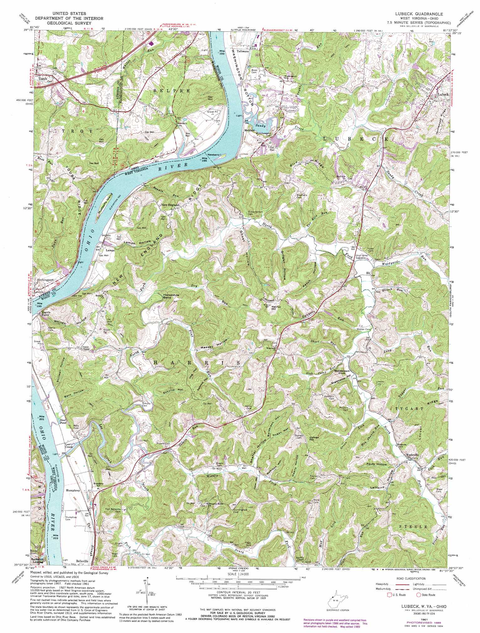
Lubeck Topo Map West Virginia
To zoom in, hover over the map of Lubeck
USGS Topo Quad 39081b6 - 1:24,000 scale
| Topo Map Name: | Lubeck |
| USGS Topo Quad ID: | 39081b6 |
| Print Size: | ca. 21 1/4" wide x 27" high |
| Southeast Coordinates: | 39.125° N latitude / 81.625° W longitude |
| Map Center Coordinates: | 39.1875° N latitude / 81.6875° W longitude |
| U.S. States: | WV, OH |
| Filename: | o39081b6.jpg |
| Download Map JPG Image: | Lubeck topo map 1:24,000 scale |
| Map Type: | Topographic |
| Topo Series: | 7.5´ |
| Map Scale: | 1:24,000 |
| Source of Map Images: | United States Geological Survey (USGS) |
| Alternate Map Versions: |
Lubeck WV 1961, updated 1963 Download PDF Buy paper map Lubeck WV 1961, updated 1972 Download PDF Buy paper map Lubeck WV 1961, updated 1979 Download PDF Buy paper map Lubeck WV 1961, updated 1989 Download PDF Buy paper map Lubeck WV 1994, updated 1998 Download PDF Buy paper map Lubeck WV 2010 Download PDF Buy paper map Lubeck WV 2014 Download PDF Buy paper map Lubeck WV 2016 Download PDF Buy paper map |
1:24,000 Topo Quads surrounding Lubeck
Amesville |
Chesterhill |
Watertown |
Fleming |
Marietta |
Stewart |
Cutler |
Little Hocking |
Parkersburg |
Valley Mills |
Alfred |
Coolville |
Lubeck |
South Parkersburg |
Kanawha |
Chester |
Portland |
Pond Creek |
Rockport |
Elizabeth |
New Haven |
Ravenswood |
Sandyville |
Liverpool |
Reedy |
> Back to 39081a1 at 1:100,000 scale
> Back to 39080a1 at 1:250,000 scale
> Back to U.S. Topo Maps home
Lubeck topo map: Gazetteer
Lubeck: Arches
Mustapha Island Bridge elevation 187m 613′Lubeck: Bars
Sugar Camp Creek Bar elevation 177m 580′Lubeck: Bends
Horseshoe Bend elevation 192m 629′Lubeck: Cliffs
Rock Bluff elevation 196m 643′Lubeck: Dams
Lock and Dam Number 20 (historical) elevation 177m 580′Lubeck: Islands
Mustapha Island elevation 179m 587′Lubeck: Lakes
Neal Pond elevation 181m 593′Lubeck: Populated Places
Armenia (historical) elevation 192m 629′Balderson (historical) elevation 282m 925′
Binola (historical) elevation 180m 590′
Crystal Spring Lake elevation 203m 666′
DeMoor Subdivision elevation 217m 711′
Eli elevation 197m 646′
Fairview Acres elevation 199m 652′
Humphrey elevation 183m 600′
Lee Creek elevation 182m 597′
Lubeck elevation 230m 754′
Lubeck Hills elevation 229m 751′
McPherson Addition elevation 264m 866′
New England elevation 269m 882′
New England Heights Addition elevation 260m 853′
Oak (historical) elevation 195m 639′
Oak Acres elevation 195m 639′
Randolph Landing elevation 184m 603′
Remus (historical) elevation 247m 810′
Scott (historical) elevation 193m 633′
Tallmans elevation 191m 626′
Torch elevation 220m 721′
Tyner (historical) elevation 220m 721′
Wadeville elevation 211m 692′
Wakefield elevation 212m 695′
Walkers Crossing (historical) elevation 181m 593′
Washington Gardens elevation 202m 662′
Wells Subdivision elevation 224m 734′
Wesley (historical) elevation 227m 744′
Youba elevation 271m 889′
Lubeck: Post Offices
Youba Post Office (historical) elevation 268m 879′Lubeck: Ridges
Bird Ridge elevation 259m 849′Locust Ridge elevation 309m 1013′
New England Ridge elevation 261m 856′
Youba Ridge elevation 270m 885′
Lubeck: Springs
Spenser Spring elevation 186m 610′Lubeck: Streams
Beadle Run elevation 180m 590′Blake Run elevation 177m 580′
Broad Run elevation 208m 682′
Dry Run elevation 186m 610′
Elijah Run elevation 196m 643′
Gilpin Run elevation 179m 587′
Green Lick elevation 200m 656′
Gunners Run elevation 197m 646′
Hen Shanty Run elevation 204m 669′
Lee Creek elevation 182m 597′
Lick Run elevation 205m 672′
Long Run elevation 198m 649′
McCollins Run elevation 185m 606′
McGill Run elevation 218m 715′
Middle Fork Lee Creek elevation 177m 580′
North Fork Lee Creek elevation 178m 583′
Pine Run elevation 181m 593′
Rock Run elevation 177m 580′
Sandy Creek elevation 178m 583′
Short Run elevation 208m 682′
Slab Camp Run elevation 198m 649′
South Fork Lee Creek elevation 177m 580′
Sugarcamp Run elevation 177m 580′
Swan Run elevation 179m 587′
Tagger Run elevation 202m 662′
Tar Kiln Run elevation 193m 633′
Vaughts Run elevation 180m 590′
Woodyards Run elevation 194m 636′
Lubeck: Summits
College Hill elevation 291m 954′Saddle Back Knob elevation 251m 823′
Walnut Hill elevation 294m 964′
Lubeck: Valleys
Balderson Hollow elevation 211m 692′Barn Hollow elevation 199m 652′
Dugan Hollow elevation 211m 692′
Flinn Hollow elevation 202m 662′
Fouty Hollow elevation 210m 688′
Ghost Hollow elevation 190m 623′
Grogan Hollow elevation 192m 629′
Hog Hollow elevation 205m 672′
Ketch Hollow elevation 193m 633′
Lafferre Hollow elevation 206m 675′
Lamps Hollow elevation 190m 623′
Massey Hollow elevation 193m 633′
Owens Hollow elevation 211m 692′
Robison Hollow elevation 202m 662′
Sawmill Hollow elevation 205m 672′
Schultz Hollow elevation 187m 613′
Shaffer Hollow elevation 197m 646′
Stillwell Hollow elevation 199m 652′
Sugarcamp Hollow elevation 201m 659′
Whites Hollow elevation 184m 603′
Lubeck digital topo map on disk
Buy this Lubeck topo map showing relief, roads, GPS coordinates and other geographical features, as a high-resolution digital map file on DVD:
 map DVD")