Bens Run Topo Map West Virginia
To zoom in, hover over the map of Bens Run
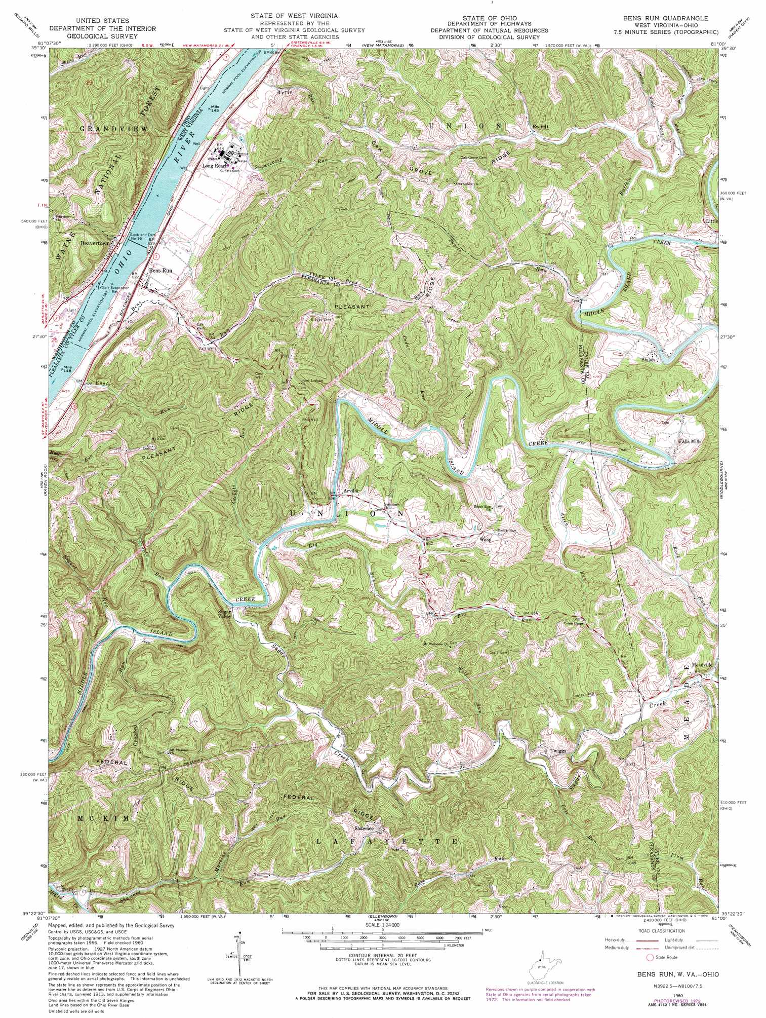
USGS Topo Quad 39081d1 - 1:24,000 scale
| Topo Map Name: | Bens Run |
| USGS Topo Quad ID: | 39081d1 |
| Print Size: | ca. 21 1/4" wide x 27" high |
| Southeast Coordinates: | 39.375° N latitude / 81° W longitude |
| Map Center Coordinates: | 39.4375° N latitude / 81.0625° W longitude |
| U.S. States: | WV, OH |
| Filename: | o39081d1.jpg |
| Download Map JPG Image: | Bens Run topo map 1:24,000 scale |
| Map Type: | Topographic |
| Topo Series: | 7.5´ |
| Map Scale: | 1:24,000 |
| Source of Map Images: | United States Geological Survey (USGS) |
| Alternate Map Versions: |
Bens Run WV 1960, updated 1962 Download PDF Buy paper map Bens Run WV 1960, updated 1970 Download PDF Buy paper map Bens Run WV 1960, updated 1973 Download PDF Buy paper map Bens Run WV 1975, updated 1979 Download PDF Buy paper map Bens Run WV 1994, updated 1998 Download PDF Buy paper map Bens Run WV 2002, updated 2006 Download PDF Buy paper map Bens Run WV 2011 Download PDF Buy paper map Bens Run WV 2014 Download PDF Buy paper map Bens Run WV 2016 Download PDF Buy paper map |
| FStopo: | US Forest Service topo Bens Run is available: Download FStopo PDF Download FStopo TIF |
1:24,000 Topo Quads surrounding Bens Run
Stafford |
Graysville |
Antioch |
Round Bottom |
New Martinsville |
Dalzell |
Rinard Mills |
New Matamoras |
Paden City |
Porters Falls |
Belmont |
Raven Rock |
Bens Run |
Middlebourne |
Shirley |
Willow Island |
Schultz |
Ellenboro |
Pennsboro |
West Union |
Petroleum |
Cairo |
Harrisville |
Pullman |
Oxford |
> Back to 39081a1 at 1:100,000 scale
> Back to 39080a1 at 1:250,000 scale
> Back to U.S. Topo Maps home
Bens Run topo map: Gazetteer
Bens Run: Channels
Long Reach elevation 185m 606′Bens Run: Dams
Chemical Landfill Dam elevation 245m 803′Lock and Dam Number 16 elevation 185m 606′
Bens Run: Populated Places
Algeria (historical) elevation 237m 777′Arvilla elevation 189m 620′
Beavertown elevation 199m 652′
Bens Run elevation 190m 623′
Everett elevation 219m 718′
Falls Mills elevation 194m 636′
Federal (historical) elevation 328m 1076′
Long Reach elevation 197m 646′
Lytton (historical) elevation 323m 1059′
Meadville elevation 225m 738′
Point Lookout elevation 302m 990′
Shiloh elevation 198m 649′
Sugar Valley elevation 187m 613′
Twiggs elevation 240m 787′
Wasp elevation 240m 787′
Bens Run: Post Offices
Bens Run Post Office elevation 195m 639′Bens Run: Ridges
Federal Ridge elevation 328m 1076′Oak Grove Ridge elevation 303m 994′
Pleasant Ridge elevation 337m 1105′
Bens Run: Springs
Hanlin Spring elevation 205m 672′Bens Run: Streams
Allen Run elevation 189m 620′Bens Run elevation 185m 606′
Big Run elevation 187m 613′
Bogart Run elevation 187m 613′
Buffalo Run elevation 193m 633′
Cedar Run elevation 188m 616′
Cole Run elevation 212m 695′
Crooked Run elevation 187m 613′
Engle Run elevation 185m 606′
Jollys Run elevation 185m 606′
Martins Run elevation 185m 606′
Martins Run elevation 221m 725′
Shawnee Run elevation 189m 620′
Sheets Run elevation 193m 633′
Stouts Run elevation 187m 613′
Sugar Creek elevation 187m 613′
Sugarcamp Run elevation 186m 610′
Tackets Run elevation 187m 613′
Wells Run elevation 189m 620′
Wolf Run elevation 204m 669′
Bens Run digital topo map on disk
Buy this Bens Run topo map showing relief, roads, GPS coordinates and other geographical features, as a high-resolution digital map file on DVD:
 map DVD")