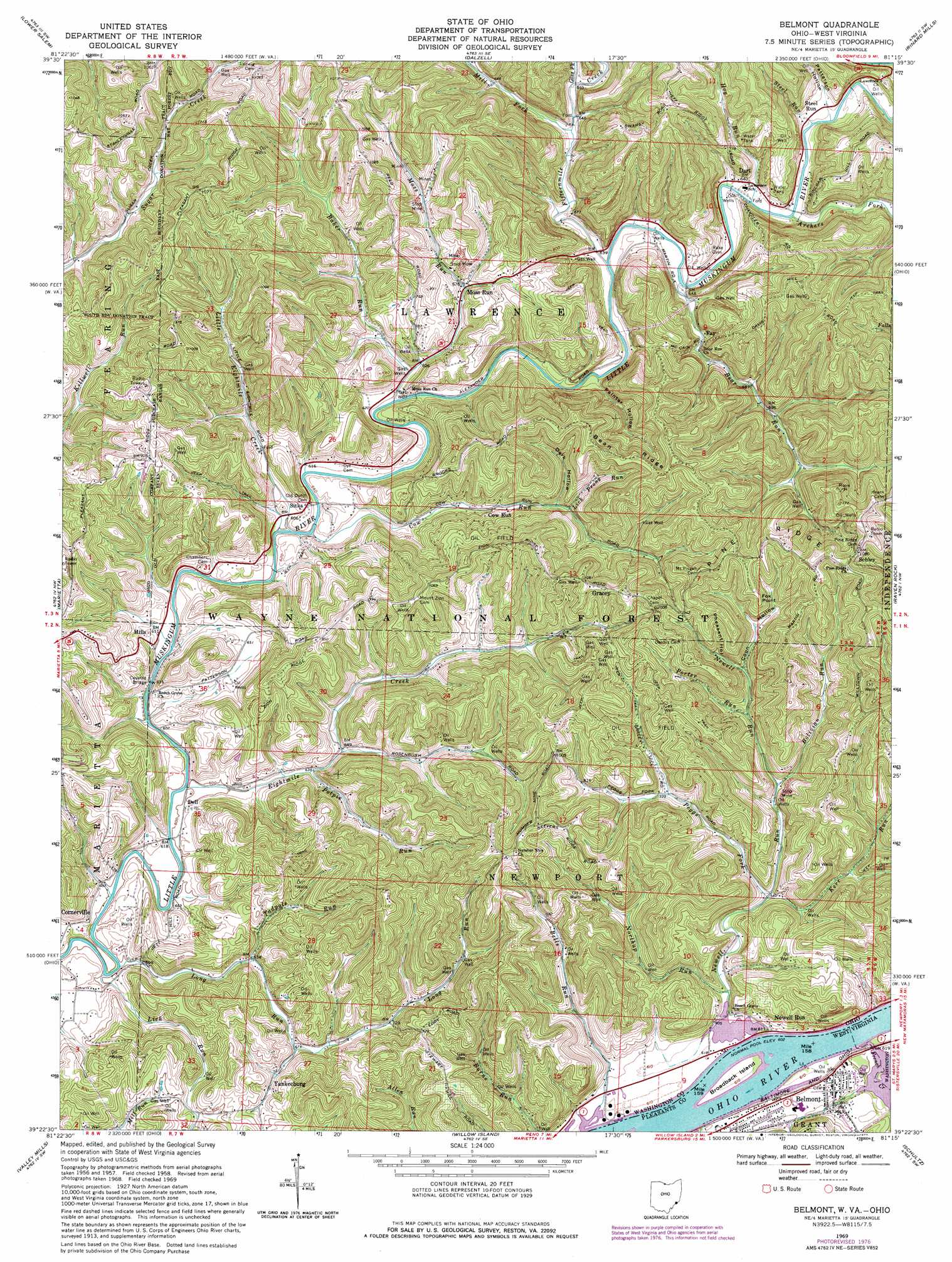
Belmont Topo Map Ohio
To zoom in, hover over the map of Belmont
USGS Topo Quad 39081d3 - 1:24,000 scale
| Topo Map Name: | Belmont |
| USGS Topo Quad ID: | 39081d3 |
| Print Size: | ca. 21 1/4" wide x 27" high |
| Southeast Coordinates: | 39.375° N latitude / 81.25° W longitude |
| Map Center Coordinates: | 39.4375° N latitude / 81.3125° W longitude |
| U.S. States: | OH, WV |
| Filename: | o39081d3.jpg |
| Download Map JPG Image: | Belmont topo map 1:24,000 scale |
| Map Type: | Topographic |
| Topo Series: | 7.5´ |
| Map Scale: | 1:24,000 |
| Source of Map Images: | United States Geological Survey (USGS) |
| Alternate Map Versions: |
Belmont WV 1958, updated 1960 Download PDF Buy paper map Belmont WV 1958, updated 1966 Download PDF Buy paper map Belmont WV 1969, updated 1971 Download PDF Buy paper map Belmont WV 1969, updated 1977 Download PDF Buy paper map Belmont WV 1976, updated 1979 Download PDF Buy paper map Belmont WV 1994, updated 1998 Download PDF Buy paper map Belmont WV 1994, updated 1998 Download PDF Buy paper map Belmont WV 2002, updated 2006 Download PDF Buy paper map Belmont WV 2011 Download PDF Buy paper map Belmont WV 2014 Download PDF Buy paper map Belmont WV 2016 Download PDF Buy paper map |
| FStopo: | US Forest Service topo Belmont is available: Download FStopo PDF Download FStopo TIF |
1:24,000 Topo Quads surrounding Belmont
Caldwell South |
Macksburg |
Stafford |
Graysville |
Antioch |
Lowell |
Lower Salem |
Dalzell |
Rinard Mills |
New Matamoras |
Fleming |
Marietta |
Belmont |
Raven Rock |
Bens Run |
Parkersburg |
Valley Mills |
Willow Island |
Schultz |
Ellenboro |
South Parkersburg |
Kanawha |
Petroleum |
Cairo |
Harrisville |
> Back to 39081a1 at 1:100,000 scale
> Back to 39080a1 at 1:250,000 scale
> Back to U.S. Topo Maps home
Belmont topo map: Gazetteer
Belmont: Bridges
Hills Hildreth Bridge elevation 183m 600′Belmont: Islands
Broadback Island elevation 187m 613′First Brother Island elevation 186m 610′
Belmont: Populated Places
Belmont elevation 196m 643′Cornerville elevation 197m 646′
Cow Run elevation 212m 695′
Dart elevation 192m 629′
Dell elevation 187m 613′
Fay elevation 199m 652′
Gracey elevation 321m 1053′
Hills elevation 195m 639′
Moss Run elevation 210m 688′
Newell Run elevation 187m 613′
Schley elevation 327m 1072′
Sitka elevation 195m 639′
Steel Run elevation 195m 639′
Yankeeburg elevation 218m 715′
Belmont: Ridges
Bean Ridge elevation 321m 1053′Belmont: Streams
Archers Fork elevation 192m 629′Baker Run elevation 196m 643′
Bear Run elevation 197m 646′
Bells Run elevation 184m 603′
Bolivian Run elevation 209m 685′
Cow Run elevation 181m 593′
Eightmile Creek elevation 183m 600′
Fifteenmile Creek elevation 192m 629′
French Creek elevation 186m 610′
Goss Fork elevation 204m 669′
Hog Run elevation 190m 623′
Kerr Run elevation 194m 636′
Lick Prong Run elevation 218m 715′
Lick Run elevation 182m 597′
Little Eightmile Creek elevation 181m 593′
Long Run elevation 181m 593′
McElroys Run elevation 184m 603′
Mill Fork elevation 199m 652′
Moss Run elevation 189m 620′
Newell Run elevation 183m 600′
Northup Run elevation 186m 610′
Peggs Fork elevation 194m 636′
Porter Run elevation 235m 770′
Potpie Run elevation 199m 652′
Steel Run elevation 194m 636′
Tadpole Run elevation 192m 629′
Belmont: Summits
Fox Point elevation 308m 1010′Belmont: Valleys
Coon Hollow elevation 231m 757′Dark Hollow elevation 233m 764′
Painter Hollow elevation 193m 633′
Patterson Hollow elevation 200m 656′
Pheasant Hollow elevation 241m 790′
Belmont digital topo map on disk
Buy this Belmont topo map showing relief, roads, GPS coordinates and other geographical features, as a high-resolution digital map file on DVD:
 map DVD")