New Matamoras Topo Map Ohio
To zoom in, hover over the map of New Matamoras
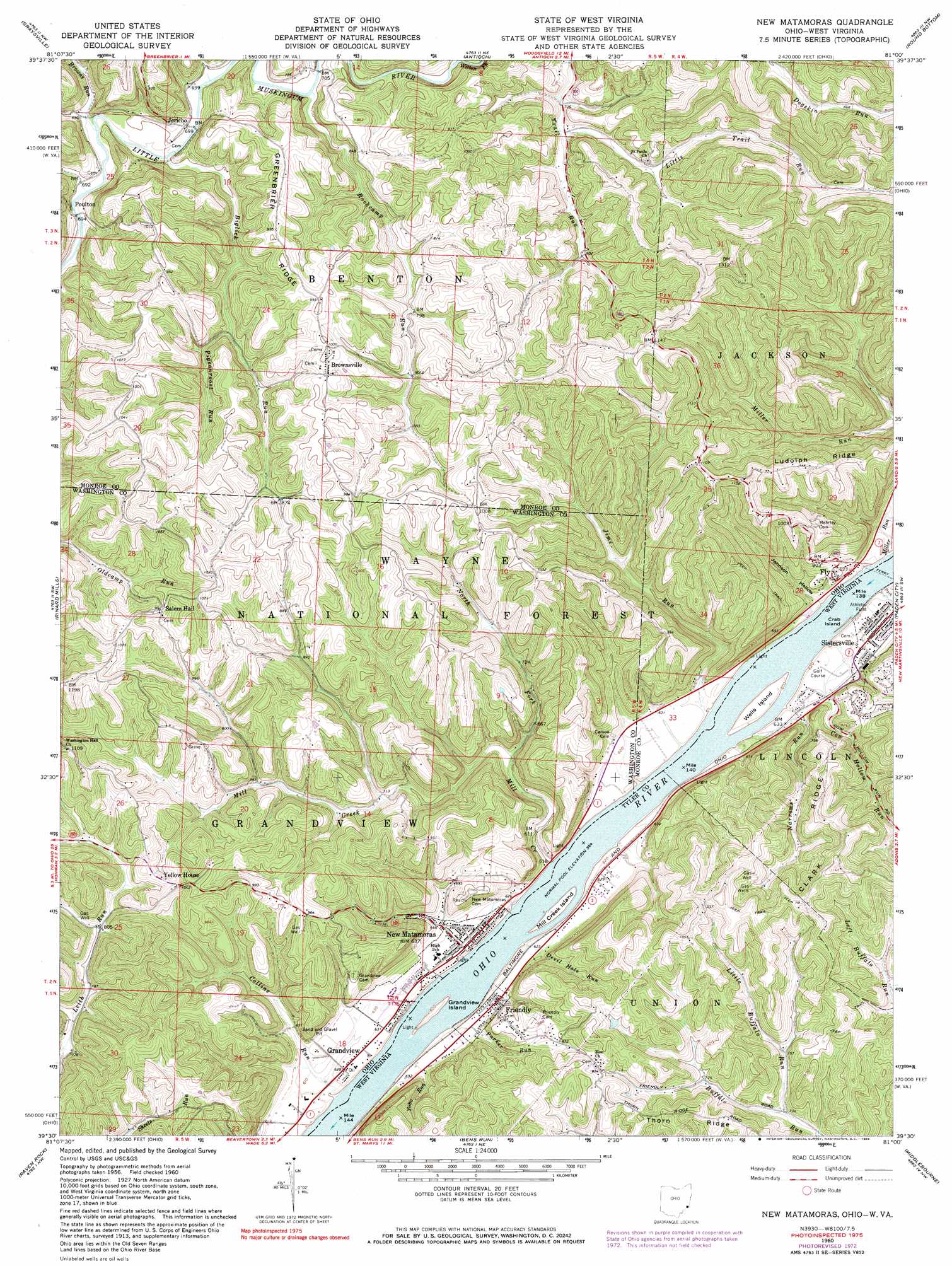
USGS Topo Quad 39081e1 - 1:24,000 scale
| Topo Map Name: | New Matamoras |
| USGS Topo Quad ID: | 39081e1 |
| Print Size: | ca. 21 1/4" wide x 27" high |
| Southeast Coordinates: | 39.5° N latitude / 81° W longitude |
| Map Center Coordinates: | 39.5625° N latitude / 81.0625° W longitude |
| U.S. States: | OH, WV |
| Filename: | o39081e1.jpg |
| Download Map JPG Image: | New Matamoras topo map 1:24,000 scale |
| Map Type: | Topographic |
| Topo Series: | 7.5´ |
| Map Scale: | 1:24,000 |
| Source of Map Images: | United States Geological Survey (USGS) |
| Alternate Map Versions: |
New Matamoras OH 1960, updated 1962 Download PDF Buy paper map New Matamoras OH 1960, updated 1970 Download PDF Buy paper map New Matamoras OH 1960, updated 1973 Download PDF Buy paper map New Matamoras OH 1960, updated 1984 Download PDF Buy paper map New Matamoras OH 1975, updated 1979 Download PDF Buy paper map New Matamoras OH 1994, updated 1998 Download PDF Buy paper map New Matamoras OH 2002, updated 2006 Download PDF Buy paper map New Matamoras OH 2011 Download PDF Buy paper map New Matamoras OH 2013 Download PDF Buy paper map New Matamoras OH 2016 Download PDF Buy paper map |
| FStopo: | US Forest Service topo New Matamoras is available: Download FStopo PDF Download FStopo TIF |
1:24,000 Topo Quads surrounding New Matamoras
Summerfield |
Lewisville |
Woodsfield |
Cameron |
Powhatan Point |
Stafford |
Graysville |
Antioch |
Round Bottom |
New Martinsville |
Dalzell |
Rinard Mills |
New Matamoras |
Paden City |
Porters Falls |
Belmont |
Raven Rock |
Bens Run |
Middlebourne |
Shirley |
Willow Island |
Schultz |
Ellenboro |
Pennsboro |
West Union |
> Back to 39081e1 at 1:100,000 scale
> Back to 39080a1 at 1:250,000 scale
> Back to U.S. Topo Maps home
New Matamoras topo map: Gazetteer
New Matamoras: Crossings
Fly Ferry elevation 185m 606′New Matamoras: Islands
Crab Island elevation 185m 606′Grandview Island elevation 188m 616′
Mill Creek Island elevation 189m 620′
Wells Island elevation 188m 616′
New Matamoras: Populated Places
Brownsville elevation 300m 984′Centerview (historical) elevation 189m 620′
Fly elevation 212m 695′
Friendly elevation 191m 626′
Grandview elevation 192m 629′
Jericho elevation 215m 705′
New Matamoras elevation 197m 646′
Poulton elevation 213m 698′
Stringtown (historical) elevation 198m 649′
Trail Run (historical) elevation 222m 728′
Wahanaker elevation 314m 1030′
New Matamoras: Post Offices
Fly Post Office elevation 218m 715′Poulton Post Office (historical) elevation 222m 728′
New Matamoras: Ridges
Clark Ridge elevation 330m 1082′Greenbrier Ridge elevation 304m 997′
Ludolph Ridge elevation 316m 1036′
Thorn Ridge elevation 302m 990′
New Matamoras: Streams
Biglick Run elevation 209m 685′Browns Run elevation 211m 692′
Collins Run elevation 185m 606′
Cow Hollow Run elevation 186m 610′
Devil Hole Run elevation 185m 606′
Grandview Run elevation 184m 603′
Jims Run elevation 185m 606′
Little Buffalo Run elevation 221m 725′
Little Trail Run elevation 224m 734′
Mill Creek elevation 185m 606′
Miller Run elevation 185m 606′
Narrows Run elevation 185m 606′
North Fork Mill Creek elevation 204m 669′
Parker Run elevation 186m 610′
Pigeonroost Run elevation 230m 754′
Rockcamp Run elevation 208m 682′
Rockcamp Run elevation 208m 682′
Tanyard Run elevation 185m 606′
Witten Fork elevation 213m 698′
Yoho Run elevation 190m 623′
New Matamoras: Valleys
Johnson Hollow elevation 185m 606′New Matamoras digital topo map on disk
Buy this New Matamoras topo map showing relief, roads, GPS coordinates and other geographical features, as a high-resolution digital map file on DVD:
 map DVD")