Stockport Topo Map Ohio
To zoom in, hover over the map of Stockport
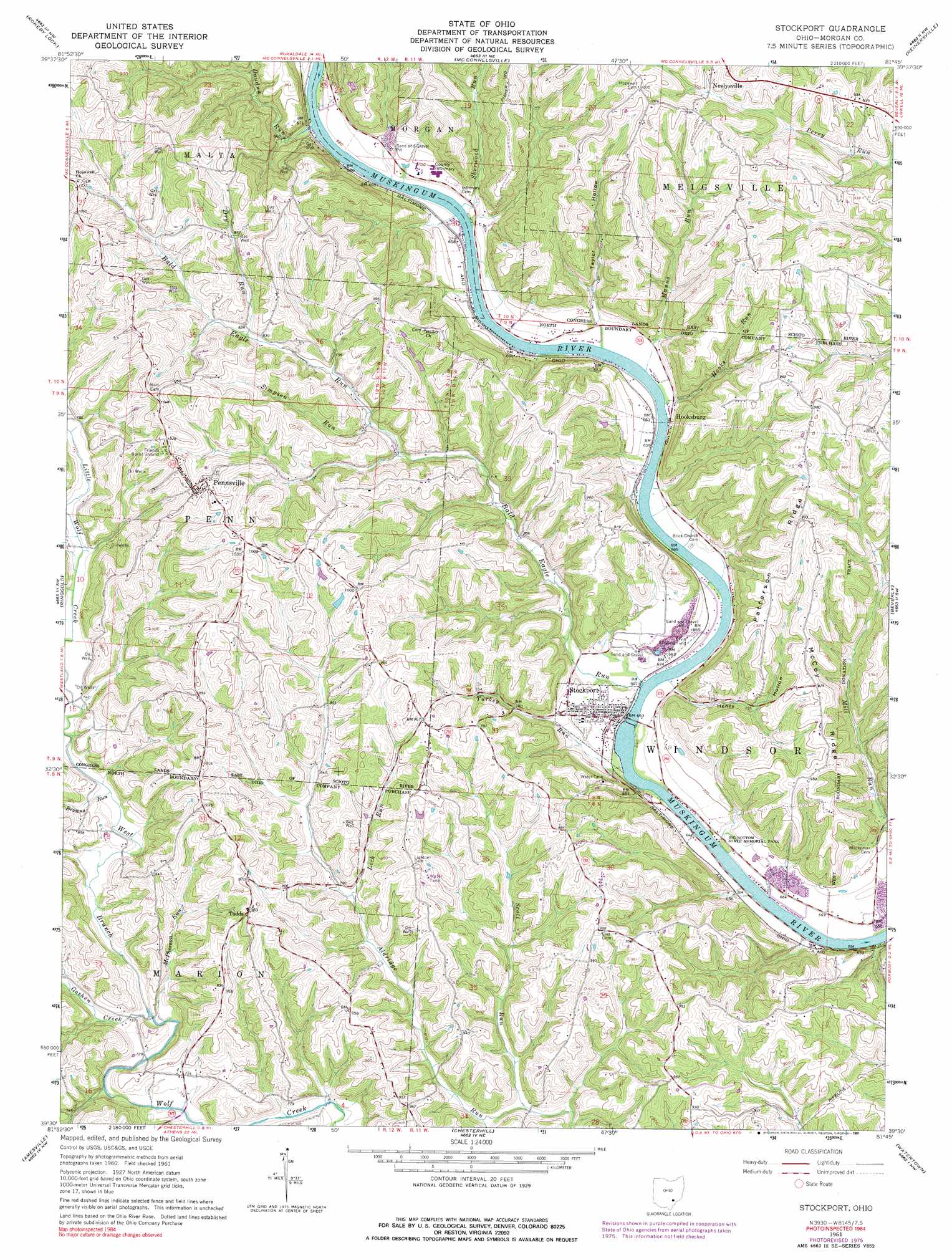
USGS Topo Quad 39081e7 - 1:24,000 scale
| Topo Map Name: | Stockport |
| USGS Topo Quad ID: | 39081e7 |
| Print Size: | ca. 21 1/4" wide x 27" high |
| Southeast Coordinates: | 39.5° N latitude / 81.75° W longitude |
| Map Center Coordinates: | 39.5625° N latitude / 81.8125° W longitude |
| U.S. State: | OH |
| Filename: | o39081e7.jpg |
| Download Map JPG Image: | Stockport topo map 1:24,000 scale |
| Map Type: | Topographic |
| Topo Series: | 7.5´ |
| Map Scale: | 1:24,000 |
| Source of Map Images: | United States Geological Survey (USGS) |
| Alternate Map Versions: |
Stockport OH 1961, updated 1963 Download PDF Buy paper map Stockport OH 1961, updated 1977 Download PDF Buy paper map Stockport OH 1961, updated 1991 Download PDF Buy paper map Stockport OH 1994, updated 1998 Download PDF Buy paper map Stockport OH 2010 Download PDF Buy paper map Stockport OH 2013 Download PDF Buy paper map Stockport OH 2016 Download PDF Buy paper map |
1:24,000 Topo Quads surrounding Stockport
Crooksville |
Philo |
Ruraldale |
Cumberland |
Caldwell North |
Deavertown |
Rokeby Lock |
Mcconnelsville |
Reinersville |
Caldwell South |
Corning |
Ringgold |
Stockport |
Beverly |
Lowell |
Jacksonville |
Amesville |
Chesterhill |
Watertown |
Fleming |
Athens |
Stewart |
Cutler |
Little Hocking |
Parkersburg |
> Back to 39081e1 at 1:100,000 scale
> Back to 39080a1 at 1:250,000 scale
> Back to U.S. Topo Maps home
Stockport topo map: Gazetteer
Stockport: Airports
Bald Eagle Field elevation 204m 669′Pennsville Heliport elevation 300m 984′
Stockport: Dams
Halley Pond Dam elevation 296m 971′Muskingum River Lock and Dam Number Six elevation 195m 639′
Stockport: Parks
Big Bottom State Memorial Park elevation 200m 656′Stockport: Populated Places
Chadwick (historical) elevation 274m 898′Hooksburg elevation 195m 639′
Lovell elevation 200m 656′
Pennsville elevation 301m 987′
Stockport elevation 211m 692′
Todds elevation 304m 997′
Stockport: Post Offices
Hooksburg Post Office (historical) elevation 200m 656′Pennsville Post Office elevation 303m 994′
Ringgold Post Office (historical) elevation 280m 918′
Stockport Post Office elevation 212m 695′
Todds Post Office (historical) elevation 301m 987′
Stockport: Reservoirs
Halley Pond elevation 296m 971′Muskingum River Lock and Dam Number elevation 195m 639′
Stockport: Ridges
McCoy Ridge elevation 282m 925′Patterson Ridge elevation 305m 1000′
Stockport: Streams
Bald Eagle Run elevation 201m 659′Browns Run elevation 221m 725′
Doudna Run elevation 202m 662′
Dry Run elevation 249m 816′
Goshen Creek elevation 220m 721′
Hooks Run elevation 194m 636′
Lick Run elevation 239m 784′
Manns Run elevation 189m 620′
McPherson Run elevation 219m 718′
Scott Run elevation 219m 718′
Sherwood Run elevation 198m 649′
Simpson Run elevation 235m 770′
Turkey Run elevation 194m 636′
Stockport: Valleys
Henry Hollow elevation 199m 652′Taylor Hollow elevation 206m 675′
Stockport digital topo map on disk
Buy this Stockport topo map showing relief, roads, GPS coordinates and other geographical features, as a high-resolution digital map file on DVD:
 map DVD")