Rokeby Lock Topo Map Ohio
To zoom in, hover over the map of Rokeby Lock
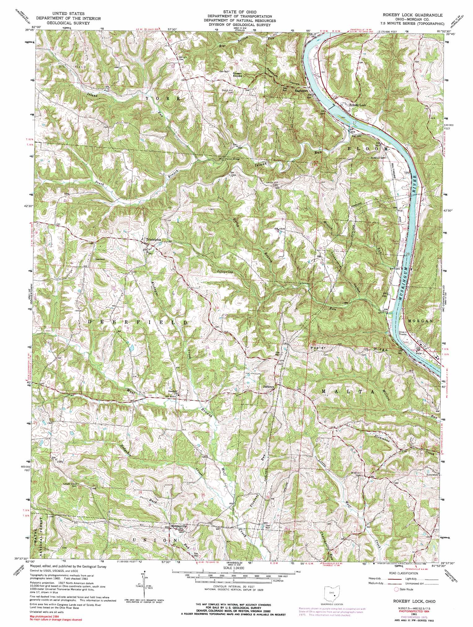
USGS Topo Quad 39081f8 - 1:24,000 scale
| Topo Map Name: | Rokeby Lock |
| USGS Topo Quad ID: | 39081f8 |
| Print Size: | ca. 21 1/4" wide x 27" high |
| Southeast Coordinates: | 39.625° N latitude / 81.875° W longitude |
| Map Center Coordinates: | 39.6875° N latitude / 81.9375° W longitude |
| U.S. State: | OH |
| Filename: | o39081f8.jpg |
| Download Map JPG Image: | Rokeby Lock topo map 1:24,000 scale |
| Map Type: | Topographic |
| Topo Series: | 7.5´ |
| Map Scale: | 1:24,000 |
| Source of Map Images: | United States Geological Survey (USGS) |
| Alternate Map Versions: |
Rokeby Lock OH 1961, updated 1962 Download PDF Buy paper map Rokeby Lock OH 1961, updated 1972 Download PDF Buy paper map Rokeby Lock OH 1961, updated 1977 Download PDF Buy paper map Rokeby Lock OH 1961, updated 1999 Download PDF Buy paper map Rokeby Lock OH 1994, updated 1998 Download PDF Buy paper map Rokeby Lock OH 2011 Download PDF Buy paper map Rokeby Lock OH 2013 Download PDF Buy paper map Rokeby Lock OH 2016 Download PDF Buy paper map |
| FStopo: | US Forest Service topo Rokeby Lock is available: Download FStopo PDF Download FStopo TIF |
1:24,000 Topo Quads surrounding Rokeby Lock
Gratiot |
Zanesville West |
Zanesville East |
Norwich |
New Concord |
Fultonham |
Crooksville |
Philo |
Ruraldale |
Cumberland |
New Lexington |
Deavertown |
Rokeby Lock |
Mcconnelsville |
Reinersville |
New Straitsville |
Corning |
Ringgold |
Stockport |
Beverly |
Nelsonville |
Jacksonville |
Amesville |
Chesterhill |
Watertown |
> Back to 39081e1 at 1:100,000 scale
> Back to 39080a1 at 1:250,000 scale
> Back to U.S. Topo Maps home
Rokeby Lock topo map: Gazetteer
Rokeby Lock: Bridges
Helmic Bridge elevation 233m 764′Rokeby Lock: Dams
Muskingum River Lock and Dam Number Eight elevation 206m 675′Rokeby Lock: Populated Places
Eagleport elevation 207m 679′Halls Valley (historical) elevation 275m 902′
Joetown elevation 341m 1118′
Morganville elevation 269m 882′
Rokeby Lock elevation 212m 695′
Triadelphia elevation 307m 1007′
Rokeby Lock: Post Offices
Eagleport Post Office (historical) elevation 205m 672′Halls Valley Post Office (historical) elevation 272m 892′
Morgansville Post Office (historical) elevation 271m 889′
Rokeby Lock Post Office (historical) elevation 210m 688′
Triadelphia Post Office (historical) elevation 310m 1017′
Rokeby Lock: Reservoirs
Muskingum River Lock and Dam Number elevation 206m 675′Rokeby Lock: Ridges
Poplar Ridge elevation 316m 1036′Rokeby Lock: Streams
Big Bottom Run elevation 205m 672′Hedgehog Creek elevation 243m 797′
Island Run elevation 200m 656′
Kickapoo Creek elevation 249m 816′
Moores Run elevation 201m 659′
North Branch Oilspring Run elevation 224m 734′
Oilspring Run elevation 201m 659′
Pleasant Run elevation 243m 797′
South Branch Island Run elevation 237m 777′
Rokeby Lock: Summits
Green Knobs elevation 333m 1092′Rokeby Lock: Valleys
Coopershop Hollow elevation 205m 672′Opossum Hollow elevation 207m 679′
Rokeby Lock digital topo map on disk
Buy this Rokeby Lock topo map showing relief, roads, GPS coordinates and other geographical features, as a high-resolution digital map file on DVD:
 map DVD")