Sarahsville Topo Map Ohio
To zoom in, hover over the map of Sarahsville
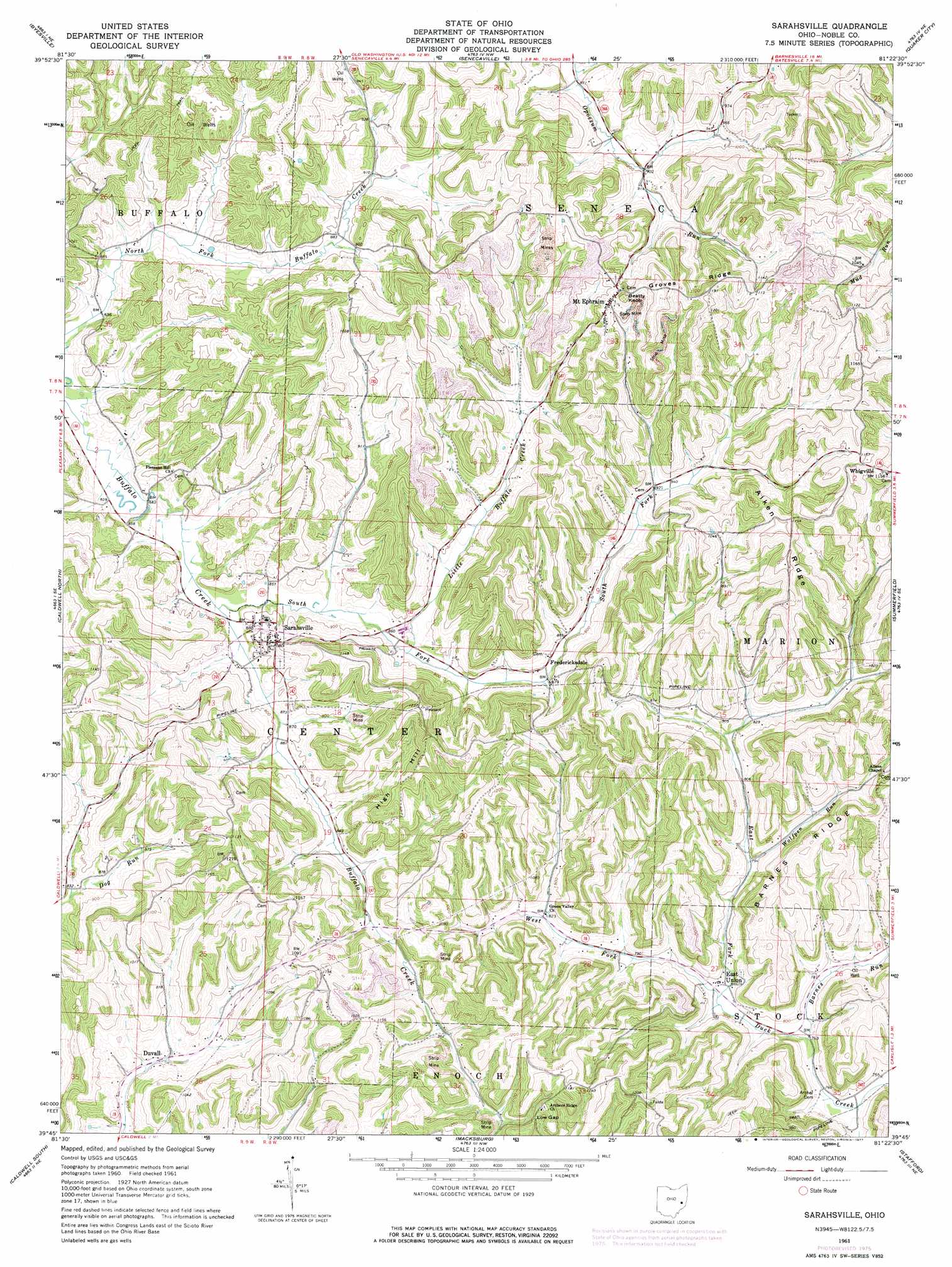
USGS Topo Quad 39081g4 - 1:24,000 scale
| Topo Map Name: | Sarahsville |
| USGS Topo Quad ID: | 39081g4 |
| Print Size: | ca. 21 1/4" wide x 27" high |
| Southeast Coordinates: | 39.75° N latitude / 81.375° W longitude |
| Map Center Coordinates: | 39.8125° N latitude / 81.4375° W longitude |
| U.S. State: | OH |
| Filename: | o39081g4.jpg |
| Download Map JPG Image: | Sarahsville topo map 1:24,000 scale |
| Map Type: | Topographic |
| Topo Series: | 7.5´ |
| Map Scale: | 1:24,000 |
| Source of Map Images: | United States Geological Survey (USGS) |
| Alternate Map Versions: |
Sarahsville OH 1961, updated 1963 Download PDF Buy paper map Sarahsville OH 1961, updated 1977 Download PDF Buy paper map Sarahsville OH 1994, updated 1998 Download PDF Buy paper map Sarahsville OH 2010 Download PDF Buy paper map Sarahsville OH 2013 Download PDF Buy paper map Sarahsville OH 2016 Download PDF Buy paper map |
1:24,000 Topo Quads surrounding Sarahsville
Bloomfield |
Cambridge |
Old Washington |
Antrim |
Fairview |
New Concord |
Byesville |
Senecaville |
Quaker City |
Barnesville |
Cumberland |
Caldwell North |
Sarahsville |
Summerfield |
Lewisville |
Reinersville |
Caldwell South |
Macksburg |
Stafford |
Graysville |
Beverly |
Lowell |
Lower Salem |
Dalzell |
Rinard Mills |
> Back to 39081e1 at 1:100,000 scale
> Back to 39080a1 at 1:250,000 scale
> Back to U.S. Topo Maps home
Sarahsville topo map: Gazetteer
Sarahsville: Gaps
Low Gap elevation 336m 1102′Sarahsville: Populated Places
Center (historical) elevation 268m 879′Duvall elevation 243m 797′
East Union elevation 234m 767′
Fredericksdale elevation 268m 879′
Mount Ephraim elevation 348m 1141′
Sarahsville elevation 295m 967′
Vorhies (historical) elevation 268m 879′
Sarahsville: Post Offices
Fredericksdale Post Office (historical) elevation 272m 892′Mount Ephraim Post Office (historical) elevation 348m 1141′
Sarahsville Post Office elevation 294m 964′
Sarahsville: Ridges
Aiken Ridge elevation 373m 1223′Barnes Ridge elevation 335m 1099′
Groves Ridge elevation 349m 1145′
Sarahsville: Streams
Barnes Run elevation 231m 757′Little Buffalo Creek elevation 262m 859′
South Fork Buffalo Creek elevation 255m 836′
West Fork East Fork Duck Creek elevation 231m 757′
Wolfpen Run elevation 243m 797′
Sarahsville: Summits
Beatty Knob elevation 370m 1213′High Hill elevation 360m 1181′
Sarahsville digital topo map on disk
Buy this Sarahsville topo map showing relief, roads, GPS coordinates and other geographical features, as a high-resolution digital map file on DVD:
 map DVD")