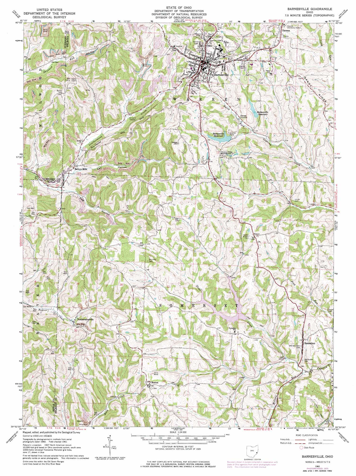
Barnesville Topo Map Ohio
To zoom in, hover over the map of Barnesville
USGS Topo Quad 39081h2 - 1:24,000 scale
| Topo Map Name: | Barnesville |
| USGS Topo Quad ID: | 39081h2 |
| Print Size: | ca. 21 1/4" wide x 27" high |
| Southeast Coordinates: | 39.875° N latitude / 81.125° W longitude |
| Map Center Coordinates: | 39.9375° N latitude / 81.1875° W longitude |
| U.S. State: | OH |
| Filename: | o39081h2.jpg |
| Download Map JPG Image: | Barnesville topo map 1:24,000 scale |
| Map Type: | Topographic |
| Topo Series: | 7.5´ |
| Map Scale: | 1:24,000 |
| Source of Map Images: | United States Geological Survey (USGS) |
| Alternate Map Versions: |
Barnesville OH 1961, updated 1963 Download PDF Buy paper map Barnesville OH 1961, updated 1972 Download PDF Buy paper map Barnesville OH 1961, updated 1976 Download PDF Buy paper map Barnesville OH 1994, updated 1998 Download PDF Buy paper map Barnesville OH 2010 Download PDF Buy paper map Barnesville OH 2013 Download PDF Buy paper map Barnesville OH 2016 Download PDF Buy paper map |
1:24,000 Topo Quads surrounding Barnesville
Birmingham |
Freeport |
Piedmont |
Flushing |
Harrisville |
Old Washington |
Antrim |
Fairview |
Bethesda |
St Clairsville |
Senecaville |
Quaker City |
Barnesville |
Hunter |
Armstrongs Mills |
Sarahsville |
Summerfield |
Lewisville |
Woodsfield |
Cameron |
Macksburg |
Stafford |
Graysville |
Antioch |
Round Bottom |
> Back to 39081e1 at 1:100,000 scale
> Back to 39080a1 at 1:250,000 scale
> Back to U.S. Topo Maps home
Barnesville topo map: Gazetteer
Barnesville: Airports
Howell Airport elevation 387m 1269′Barnesville: Dams
Barnesville Lake Dam elevation 340m 1115′Barnesville Reservoir Number One Dam elevation 351m 1151′
Barnesville Reservoir Number Three Dam elevation 323m 1059′
Barnesville Reservoir Number Two Dam elevation 341m 1118′
Livezey Lake Dam elevation 380m 1246′
Barnesville: Parks
Barnesville Historic District elevation 384m 1259′Barnesville Memorial Park elevation 379m 1243′
Barnesville: Populated Places
Baileys Mills elevation 288m 944′Barnesville elevation 387m 1269′
Boston elevation 391m 1282′
Somerton elevation 360m 1181′
Tacoma elevation 390m 1279′
Temperanceville elevation 288m 944′
Barnesville: Post Offices
Baileys Mills Post Office (historical) elevation 288m 944′Barnesville Post Office elevation 389m 1276′
Somerton Post Office elevation 360m 1181′
Temperanceville Post Office (historical) elevation 292m 958′
Barnesville: Reservoirs
Barnesville Lake elevation 340m 1115′Barnesville Reservoir elevation 350m 1148′
Barnesville Reservoir elevation 379m 1243′
Barnesville Reservoir Number Three elevation 323m 1059′
Barnesville Reservoir Number Two elevation 341m 1118′
Livezey Lake elevation 380m 1246′
Taber Lake elevation 364m 1194′
Barnesville: Streams
Chestnut Creek elevation 337m 1105′Millers Run elevation 305m 1000′
Slope Creek elevation 306m 1003′
Barnesville: Valleys
Cat Hollow elevation 276m 905′Dog Hollow elevation 275m 902′
Barnesville digital topo map on disk
Buy this Barnesville topo map showing relief, roads, GPS coordinates and other geographical features, as a high-resolution digital map file on DVD:
 map DVD")