Norwich Topo Map Ohio
To zoom in, hover over the map of Norwich
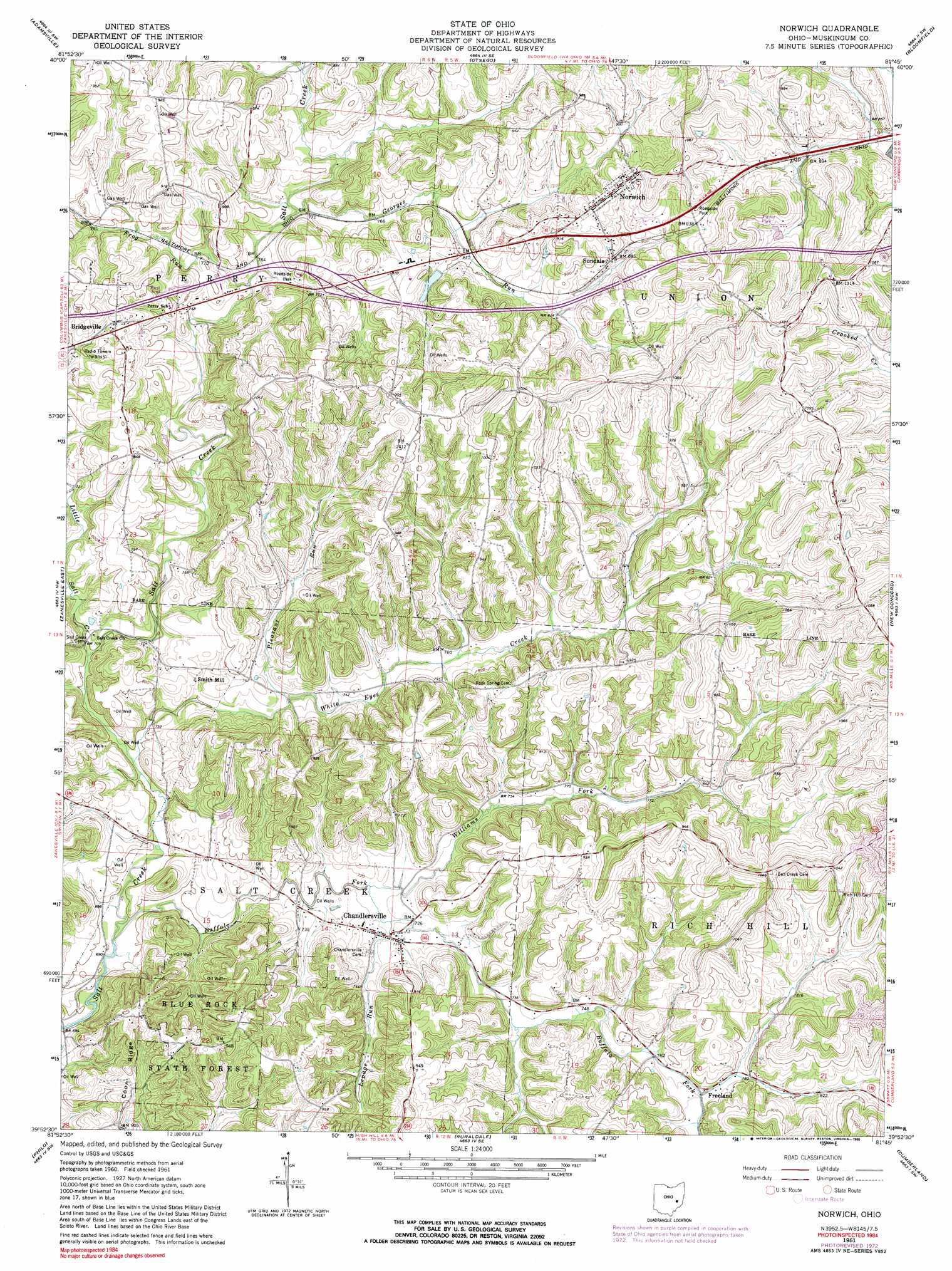
USGS Topo Quad 39081h7 - 1:24,000 scale
| Topo Map Name: | Norwich |
| USGS Topo Quad ID: | 39081h7 |
| Print Size: | ca. 21 1/4" wide x 27" high |
| Southeast Coordinates: | 39.875° N latitude / 81.75° W longitude |
| Map Center Coordinates: | 39.9375° N latitude / 81.8125° W longitude |
| U.S. State: | OH |
| Filename: | o39081h7.jpg |
| Download Map JPG Image: | Norwich topo map 1:24,000 scale |
| Map Type: | Topographic |
| Topo Series: | 7.5´ |
| Map Scale: | 1:24,000 |
| Source of Map Images: | United States Geological Survey (USGS) |
| Alternate Map Versions: |
Norwich OH 1961, updated 1963 Download PDF Buy paper map Norwich OH 1961, updated 1963 Download PDF Buy paper map Norwich OH 1961, updated 1973 Download PDF Buy paper map Norwich OH 1961, updated 1983 Download PDF Buy paper map Norwich OH 1961, updated 1990 Download PDF Buy paper map Norwich OH 1994, updated 1998 Download PDF Buy paper map Norwich OH 2010 Download PDF Buy paper map Norwich OH 2013 Download PDF Buy paper map Norwich OH 2016 Download PDF Buy paper map |
1:24,000 Topo Quads surrounding Norwich
Trinway |
Conesville |
Wills Creek |
Plainfield |
Kimbolton |
Dresden |
Adamsville |
Otsego |
Bloomfield |
Cambridge |
Zanesville West |
Zanesville East |
Norwich |
New Concord |
Byesville |
Crooksville |
Philo |
Ruraldale |
Cumberland |
Caldwell North |
Deavertown |
Rokeby Lock |
Mcconnelsville |
Reinersville |
Caldwell South |
> Back to 39081e1 at 1:100,000 scale
> Back to 39080a1 at 1:250,000 scale
> Back to U.S. Topo Maps home
Norwich topo map: Gazetteer
Norwich: Airports
Derry Landing Strip elevation 283m 928′Norwich: Bridges
Salt Creek Bridge elevation 231m 757′Norwich: Crossings
Interchange 164 elevation 250m 820′Norwich: Dams
Bakers Pond Dam elevation 253m 830′Norwich: Populated Places
Bridgeville elevation 261m 856′Chandlersville elevation 220m 721′
Freeland elevation 239m 784′
Lawton (historical) elevation 213m 698′
Norwich elevation 296m 971′
Rich Hill (historical) elevation 342m 1122′
Seawright (historical) elevation 214m 702′
Smith (historical) elevation 227m 744′
Smith Mill elevation 226m 741′
Sundale elevation 267m 875′
Norwich: Post Offices
Bridgeville Post Office (historical) elevation 258m 846′Chandersville Post Office elevation 221m 725′
Freeland Post Office (historical) elevation 235m 770′
Lawton Post Office (historical) elevation 214m 702′
Norwich Post Office elevation 292m 958′
Rich Hill Post Office (historical) elevation 342m 1122′
Sun Dale Post Office (historical) elevation 272m 892′
Norwich: Reservoirs
Bakers Pond elevation 253m 830′Norwich: Ridges
Coon Ridge elevation 284m 931′Norwich: Streams
Buck Run elevation 259m 849′Buffalo Fork elevation 207m 679′
Frog Run elevation 227m 744′
Georges Run elevation 225m 738′
Lepage Run elevation 219m 718′
Little Salt Creek elevation 212m 695′
Pleasant Run elevation 219m 718′
White Eyes Creek elevation 210m 688′
Williams Fork elevation 217m 711′
Norwich digital topo map on disk
Buy this Norwich topo map showing relief, roads, GPS coordinates and other geographical features, as a high-resolution digital map file on DVD:
 map DVD")