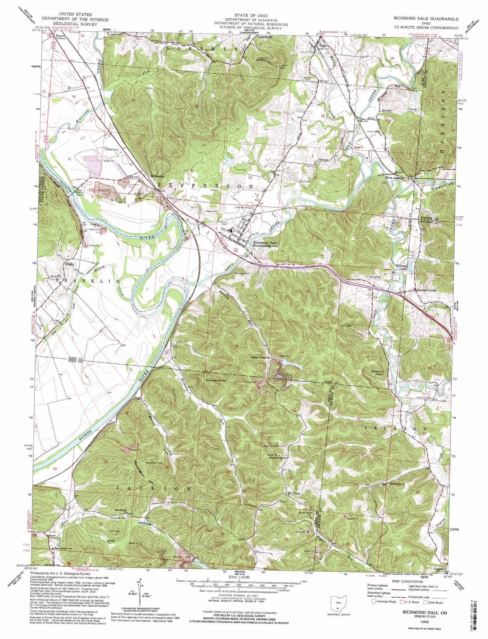
Richmond Dale Topo Map Ohio
To zoom in, hover over the map of Richmond Dale
USGS Topo Quad 39082b7 - 1:24,000 scale
| Topo Map Name: | Richmond Dale |
| USGS Topo Quad ID: | 39082b7 |
| Print Size: | ca. 21 1/4" wide x 27" high |
| Southeast Coordinates: | 39.125° N latitude / 82.75° W longitude |
| Map Center Coordinates: | 39.1875° N latitude / 82.8125° W longitude |
| U.S. State: | OH |
| Filename: | o39082b7.jpg |
| Download Map JPG Image: | Richmond Dale topo map 1:24,000 scale |
| Map Type: | Topographic |
| Topo Series: | 7.5´ |
| Map Scale: | 1:24,000 |
| Source of Map Images: | United States Geological Survey (USGS) |
| Alternate Map Versions: |
Richmond Dale OH 1961, updated 1963 Download PDF Buy paper map Richmond Dale OH 1961, updated 1985 Download PDF Buy paper map Richmond Dale OH 1992, updated 1995 Download PDF Buy paper map Richmond Dale OH 2010 Download PDF Buy paper map Richmond Dale OH 2013 Download PDF Buy paper map Richmond Dale OH 2016 Download PDF Buy paper map |
1:24,000 Topo Quads surrounding Richmond Dale
Andersonville |
Kingston |
Hallsville |
Laurelville |
South Bloomingville |
Chillicothe West |
Chillicothe East |
Londonderry |
Ratcliffburg |
Allensville |
Summithill |
Waverly North |
Richmond Dale |
Byer |
Hamden |
Piketon |
Waverly South |
Beaver |
Jackson |
Wellston |
Wakefield |
Lucasville |
Stockdale |
Petersburg |
Oak Hill |
> Back to 39082a1 at 1:100,000 scale
> Back to 39082a1 at 1:250,000 scale
> Back to U.S. Topo Maps home
Richmond Dale topo map: Gazetteer
Richmond Dale: Cliffs
Buzzard Rock elevation 253m 830′Richmond Dale: Dams
Hay Hollow Reservoir Dam elevation 219m 718′Southern Silica Pond Number One Dam elevation 250m 820′
Southern Silica Pond Number Two Dam elevation 246m 807′
Richmond Dale: Lakes
Gillums Lake elevation 187m 613′Richmond Dale: Populated Places
Brocks Corner elevation 193m 633′Canada (historical) elevation 189m 620′
Higby elevation 181m 593′
Limerick elevation 192m 629′
Mount Sinai elevation 302m 990′
Richmond Dale elevation 181m 593′
Rittenours elevation 183m 600′
Vigo elevation 187m 613′
West Junction elevation 185m 606′
Richmond Dale: Post Offices
Higby Post Office (historical) elevation 181m 593′Limerick Post Office (historical) elevation 190m 623′
Richmond Dale Post Office elevation 178m 583′
Vigo Post Office (historical) elevation 189m 620′
Richmond Dale: Reservoirs
Hay Hollow Reservoir elevation 219m 718′Southern Silica Pond Number One elevation 250m 820′
Southern Silica Pond Number Two elevation 246m 807′
Richmond Dale: Streams
Goose Creek elevation 177m 580′Hickson Run elevation 176m 577′
Jackson Run elevation 180m 590′
Lick Run elevation 179m 587′
Middle Fork Salt Creek elevation 177m 580′
Mulgee Creek elevation 177m 580′
Mutton Run elevation 182m 597′
Pigeon Creek elevation 180m 590′
Salt Creek elevation 175m 574′
Salt Lick Creek elevation 177m 580′
Sandy Bottom Creek elevation 174m 570′
Walnut Creek elevation 176m 577′
Whisky Run elevation 175m 574′
Richmond Dale: Summits
Chimney Rocks elevation 342m 1122′Weddington Hill elevation 324m 1062′
Richmond Dale: Valleys
Hay Hollow elevation 180m 590′Sycamore Hollow elevation 189m 620′
Richmond Dale digital topo map on disk
Buy this Richmond Dale topo map showing relief, roads, GPS coordinates and other geographical features, as a high-resolution digital map file on DVD:
 map DVD")