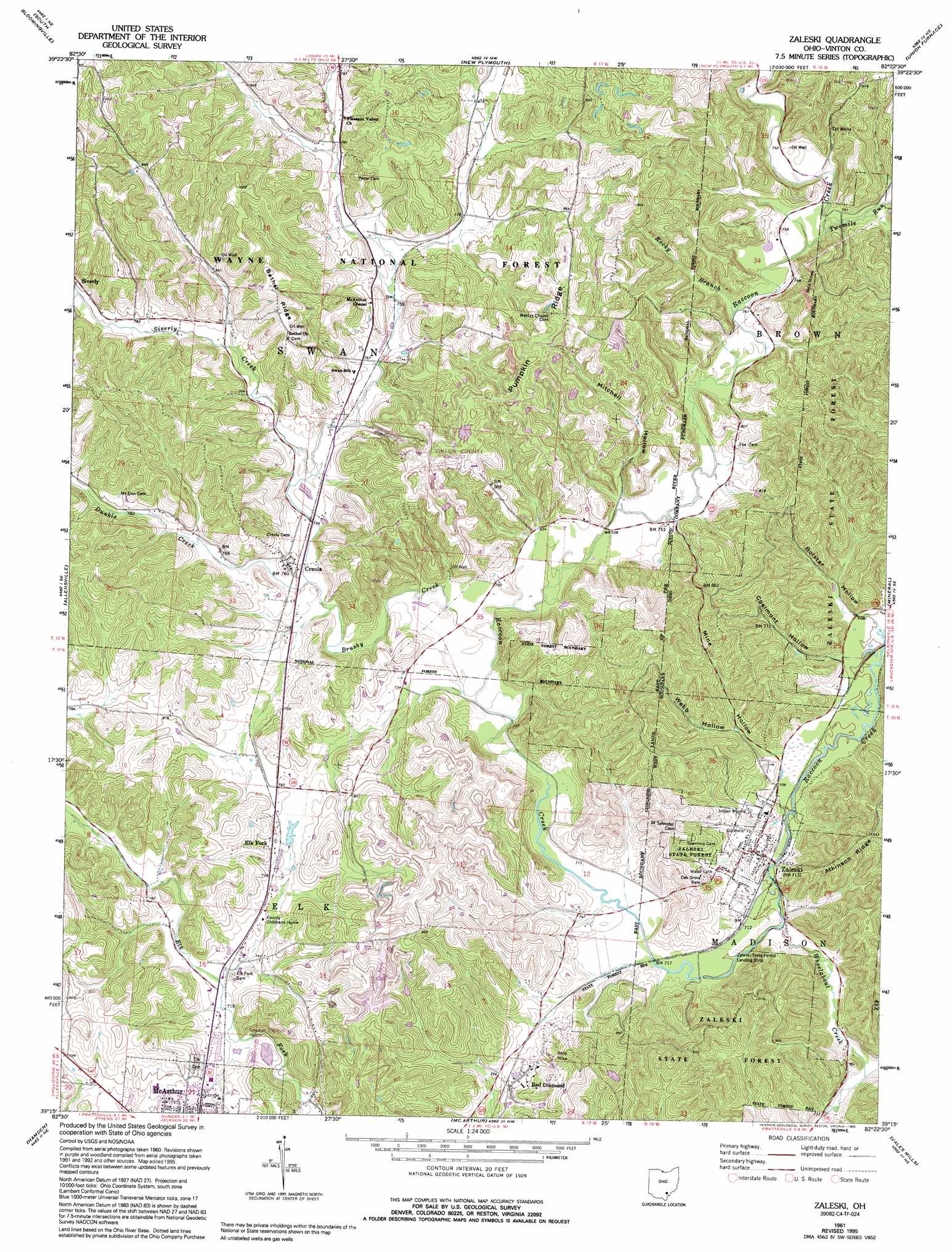
Zaleski Topo Map Ohio
To zoom in, hover over the map of Zaleski
USGS Topo Quad 39082c4 - 1:24,000 scale
| Topo Map Name: | Zaleski |
| USGS Topo Quad ID: | 39082c4 |
| Print Size: | ca. 21 1/4" wide x 27" high |
| Southeast Coordinates: | 39.25° N latitude / 82.375° W longitude |
| Map Center Coordinates: | 39.3125° N latitude / 82.4375° W longitude |
| U.S. State: | OH |
| Filename: | o39082c4.jpg |
| Download Map JPG Image: | Zaleski topo map 1:24,000 scale |
| Map Type: | Topographic |
| Topo Series: | 7.5´ |
| Map Scale: | 1:24,000 |
| Source of Map Images: | United States Geological Survey (USGS) |
| Alternate Map Versions: |
Zaleski OH 1961, updated 1963 Download PDF Buy paper map Zaleski OH 1961, updated 1971 Download PDF Buy paper map Zaleski OH 1961, updated 1977 Download PDF Buy paper map Zaleski OH 1961, updated 1985 Download PDF Buy paper map Zaleski OH 1961, updated 1995 Download PDF Buy paper map Zaleski OH 2002, updated 2006 Download PDF Buy paper map Zaleski OH 2011 Download PDF Buy paper map Zaleski OH 2013 Download PDF Buy paper map Zaleski OH 2016 Download PDF Buy paper map |
| FStopo: | US Forest Service topo Zaleski is available: Download FStopo PDF Download FStopo TIF |
1:24,000 Topo Quads surrounding Zaleski
Clearport |
Rockbridge |
Logan |
Gore |
New Straitsville |
Laurelville |
South Bloomingville |
New Plymouth |
Union Furnace |
Nelsonville |
Ratcliffburg |
Allensville |
Zaleski |
Mineral |
The Plains |
Byer |
Hamden |
Mcarthur |
Vales Mills |
Albany |
Jackson |
Wellston |
Mulga |
Wilkesville |
Rutland |
> Back to 39082a1 at 1:100,000 scale
> Back to 39082a1 at 1:250,000 scale
> Back to U.S. Topo Maps home
Zaleski topo map: Gazetteer
Zaleski: Airports
Vinton County Airport elevation 287m 941′Zaleski State Forest Landing Strip elevation 214m 702′
Zaleski: Bridges
Cox Bridge elevation 238m 780′Zaleski: Forests
Zaleski State Forest elevation 284m 931′Zaleski: Populated Places
Creola elevation 232m 761′Elk Fork elevation 240m 787′
Red Diamond elevation 235m 770′
Siverly elevation 246m 807′
Ural (historical) elevation 219m 718′
Zaleski elevation 230m 754′
Zaleski: Ridges
Bethel Ridge elevation 295m 967′Pumpkin Ridge elevation 305m 1000′
Zaleski: Streams
Brushy Creek elevation 219m 718′Brushy Fork elevation 231m 757′
Dunkle Creek elevation 224m 734′
Rocky Branch elevation 218m 715′
Siverly Creek elevation 225m 738′
Twomile Run elevation 225m 738′
Wheelabout Creek elevation 213m 698′
Zaleski: Summits
The Pinnacle elevation 319m 1046′Zaleski: Valleys
Bolster Hollow elevation 213m 698′Coalmont Hollow elevation 217m 711′
Mine Hollow elevation 216m 708′
Mitchell Hollow elevation 219m 718′
Webb Hollow elevation 223m 731′
Zaleski digital topo map on disk
Buy this Zaleski topo map showing relief, roads, GPS coordinates and other geographical features, as a high-resolution digital map file on DVD:
 map DVD")