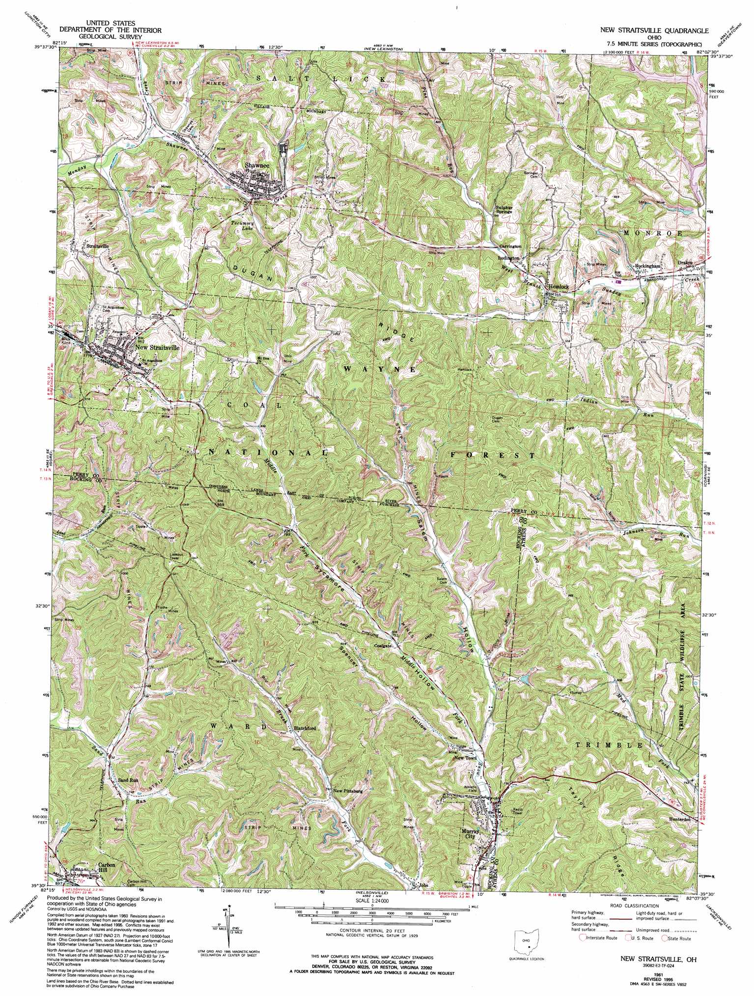
New Straitsville Topo Map Ohio
To zoom in, hover over the map of New Straitsville
USGS Topo Quad 39082e2 - 1:24,000 scale
| Topo Map Name: | New Straitsville |
| USGS Topo Quad ID: | 39082e2 |
| Print Size: | ca. 21 1/4" wide x 27" high |
| Southeast Coordinates: | 39.5° N latitude / 82.125° W longitude |
| Map Center Coordinates: | 39.5625° N latitude / 82.1875° W longitude |
| U.S. State: | OH |
| Filename: | o39082e2.jpg |
| Download Map JPG Image: | New Straitsville topo map 1:24,000 scale |
| Map Type: | Topographic |
| Topo Series: | 7.5´ |
| Map Scale: | 1:24,000 |
| Source of Map Images: | United States Geological Survey (USGS) |
| Alternate Map Versions: |
New Straitsville OH 1961, updated 1962 Download PDF Buy paper map New Straitsville OH 1961, updated 1971 Download PDF Buy paper map New Straitsville OH 1961, updated 1976 Download PDF Buy paper map New Straitsville OH 1961, updated 1985 Download PDF Buy paper map New Straitsville OH 1961, updated 1992 Download PDF Buy paper map New Straitsville OH 1961, updated 1995 Download PDF Buy paper map New Straitsville OH 2002, updated 2006 Download PDF Buy paper map New Straitsville OH 2011 Download PDF Buy paper map New Straitsville OH 2013 Download PDF Buy paper map New Straitsville OH 2016 Download PDF Buy paper map |
| FStopo: | US Forest Service topo New Straitsville is available: Download FStopo PDF Download FStopo TIF |
1:24,000 Topo Quads surrounding New Straitsville
Rushville |
Somerset |
Fultonham |
Crooksville |
Philo |
Bremen |
Junction City |
New Lexington |
Deavertown |
Rokeby Lock |
Logan |
Gore |
New Straitsville |
Corning |
Ringgold |
New Plymouth |
Union Furnace |
Nelsonville |
Jacksonville |
Amesville |
Zaleski |
Mineral |
The Plains |
Athens |
Stewart |
> Back to 39082e1 at 1:100,000 scale
> Back to 39082a1 at 1:250,000 scale
> Back to U.S. Topo Maps home
New Straitsville topo map: Gazetteer
New Straitsville: Dams
Wayne National Forest Dam elevation 263m 862′New Straitsville: Forests
Wayne National Forest - Athens Ranger District - Athens Unit elevation 253m 830′New Straitsville: Lakes
Tecumsey Lake elevation 252m 826′New Straitsville: Parks
Shawnee Historic District elevation 251m 823′Sunday Creek State Wildlife Area elevation 267m 875′
New Straitsville: Populated Places
Blatchford elevation 234m 767′Buckingham elevation 225m 738′
Carbon Hill elevation 217m 711′
Carrington elevation 235m 770′
Coalgate elevation 225m 738′
Consol (historical) elevation 225m 738′
Drakes elevation 236m 774′
Hemlock elevation 232m 761′
Jobs elevation 220m 721′
Lost Run (historical) elevation 249m 816′
Ludington elevation 232m 761′
Murray City elevation 216m 708′
New Pittsburg elevation 234m 767′
New Straitsville elevation 240m 787′
New Town elevation 219m 718′
Sand Run elevation 225m 738′
Shawnee elevation 260m 853′
Straitsville elevation 298m 977′
Sulphur Springs elevation 239m 784′
New Straitsville: Post Offices
Blatchford Post Office (historical) elevation 241m 790′Carbon Hill Post Office elevation 214m 702′
Carrington Post Office (historical) elevation 233m 764′
Coalgate Post Office (historical) elevation 224m 734′
Consol Post Office (historical) elevation 238m 780′
Hemlock Post Office elevation 232m 761′
Jobs Post Office (historical) elevation 222m 728′
Murray City Post Office (historical) elevation 214m 702′
New Straitsville Post Office elevation 240m 787′
Sandrun Post Office (historical) elevation 223m 731′
Shawnee Post Office elevation 255m 836′
New Straitsville: Reservoirs
Wayne National Forest Pond elevation 263m 862′New Straitsville: Ridges
Dugan Ridge elevation 312m 1023′New Straitsville: Streams
Middle Fork Snow Fork elevation 218m 715′Pine Run elevation 240m 787′
Shawnee Creek elevation 235m 770′
New Straitsville: Trails
Buckeye Trail elevation 311m 1020′New Straitsville: Valleys
Salem Hollow elevation 219m 718′Spencer Hollow elevation 218m 715′
Sycamore Hollow elevation 219m 718′
New Straitsville digital topo map on disk
Buy this New Straitsville topo map showing relief, roads, GPS coordinates and other geographical features, as a high-resolution digital map file on DVD:
 map DVD")