Clearport Topo Map Ohio
To zoom in, hover over the map of Clearport
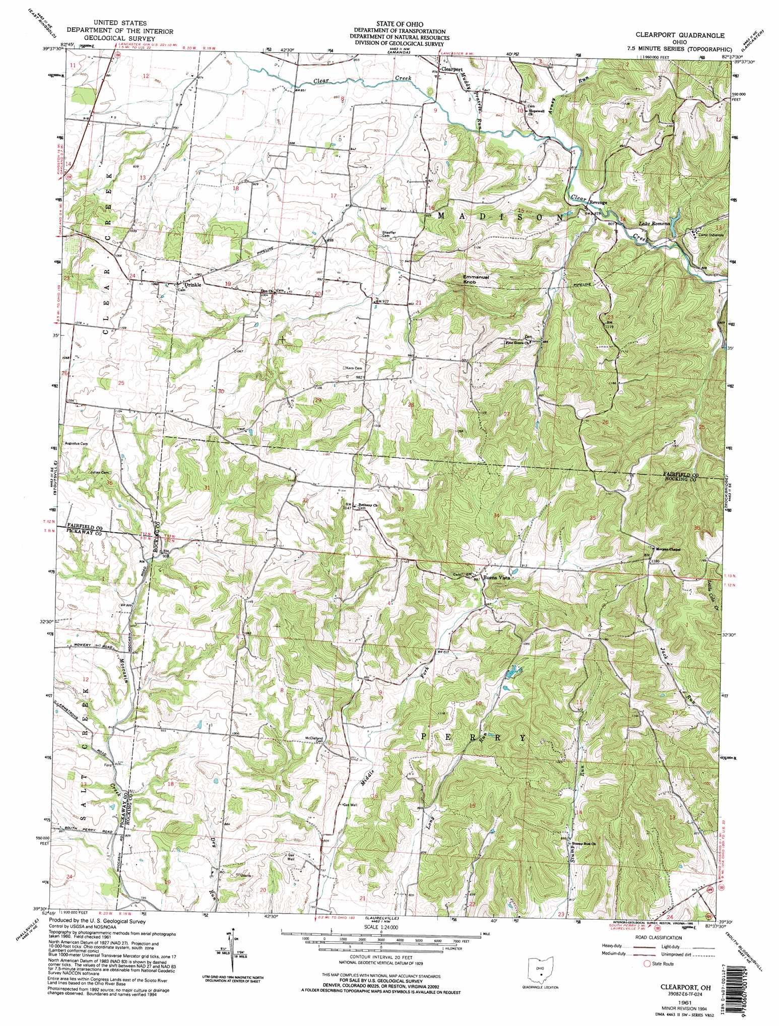
USGS Topo Quad 39082e6 - 1:24,000 scale
| Topo Map Name: | Clearport |
| USGS Topo Quad ID: | 39082e6 |
| Print Size: | ca. 21 1/4" wide x 27" high |
| Southeast Coordinates: | 39.5° N latitude / 82.625° W longitude |
| Map Center Coordinates: | 39.5625° N latitude / 82.6875° W longitude |
| U.S. State: | OH |
| Filename: | o39082e6.jpg |
| Download Map JPG Image: | Clearport topo map 1:24,000 scale |
| Map Type: | Topographic |
| Topo Series: | 7.5´ |
| Map Scale: | 1:24,000 |
| Source of Map Images: | United States Geological Survey (USGS) |
| Alternate Map Versions: |
Clearport OH 1961, updated 1963 Download PDF Buy paper map Clearport OH 1961, updated 1972 Download PDF Buy paper map Clearport OH 1961, updated 1984 Download PDF Buy paper map Clearport OH 1961, updated 1995 Download PDF Buy paper map Clearport OH 2010 Download PDF Buy paper map Clearport OH 2013 Download PDF Buy paper map Clearport OH 2016 Download PDF Buy paper map |
1:24,000 Topo Quads surrounding Clearport
Lockbourne |
Canal Winchester |
Carroll |
Baltimore |
Rushville |
Ashville |
East Ringgold |
Amanda |
Lancaster |
Bremen |
Circleville |
Stoutsville |
Clearport |
Rockbridge |
Logan |
Kingston |
Hallsville |
Laurelville |
South Bloomingville |
New Plymouth |
Chillicothe East |
Londonderry |
Ratcliffburg |
Allensville |
Zaleski |
> Back to 39082e1 at 1:100,000 scale
> Back to 39082a1 at 1:250,000 scale
> Back to U.S. Topo Maps home
Clearport topo map: Gazetteer
Clearport: Bridges
Hanaway Bridge elevation 254m 833′Johnson Bridge elevation 249m 816′
Clearport: Dams
Lake Romona Dam elevation 254m 833′Snortin Ridge Farm Lake Dam elevation 258m 846′
Clearport: Populated Places
Blackburn (historical) elevation 288m 944′Buena Vista elevation 274m 898′
Clearport elevation 258m 846′
Drinkle elevation 333m 1092′
Revenge elevation 248m 813′
Clearport: Post Offices
Clearport Post Office (historical) elevation 257m 843′Revenge Post Office (historical) elevation 250m 820′
Clearport: Reservoirs
Lake Romona elevation 254m 833′Snortin Ridge Farm Lake elevation 258m 846′
Clearport: Streams
Arney Run elevation 248m 813′Muddy Prairie Run elevation 251m 823′
Clearport: Summits
Emmanuel Knob elevation 354m 1161′Clearport digital topo map on disk
Buy this Clearport topo map showing relief, roads, GPS coordinates and other geographical features, as a high-resolution digital map file on DVD:
 map DVD")