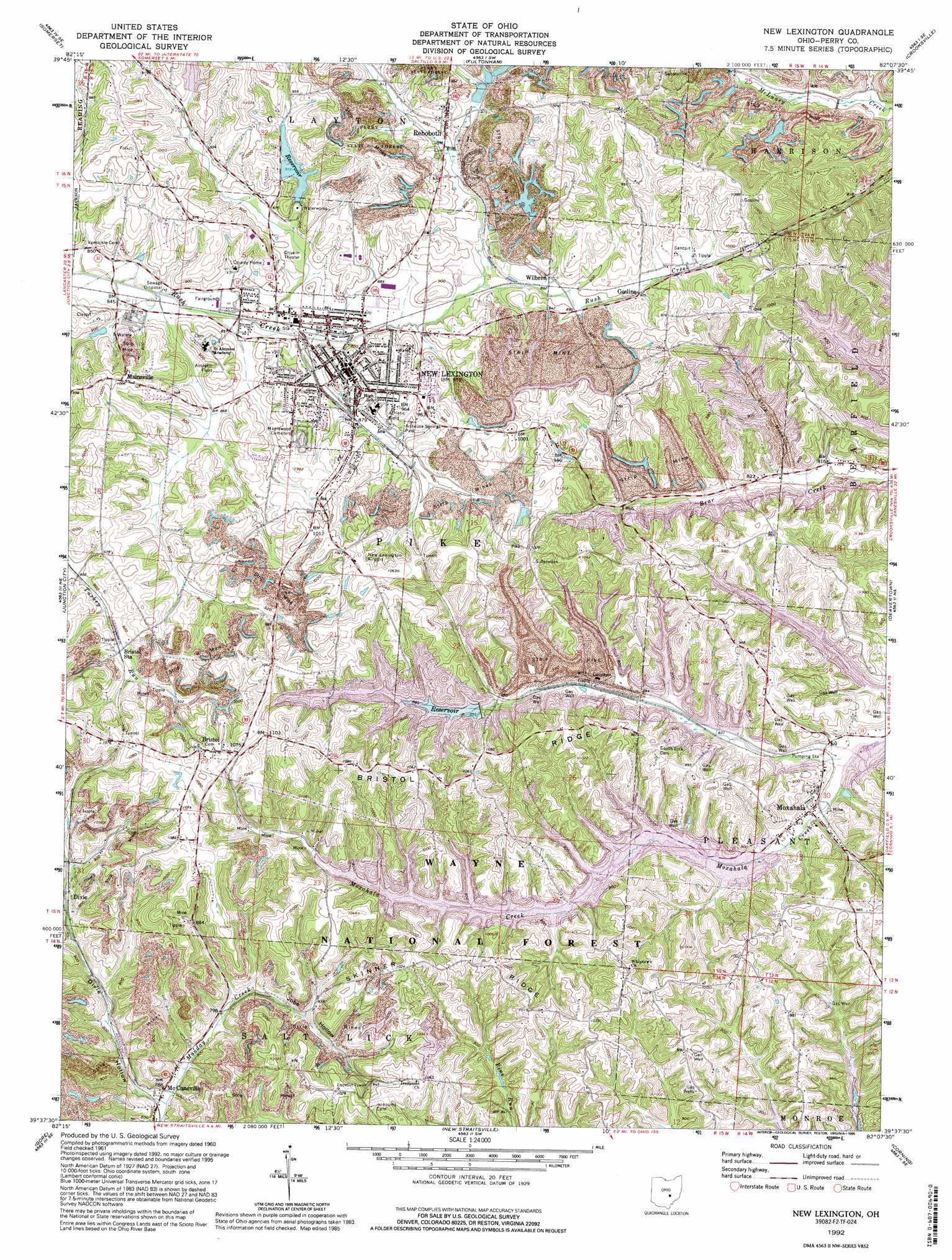
New Lexington Topo Map Ohio
To zoom in, hover over the map of New Lexington
USGS Topo Quad 39082f2 - 1:24,000 scale
| Topo Map Name: | New Lexington |
| USGS Topo Quad ID: | 39082f2 |
| Print Size: | ca. 21 1/4" wide x 27" high |
| Southeast Coordinates: | 39.625° N latitude / 82.125° W longitude |
| Map Center Coordinates: | 39.6875° N latitude / 82.1875° W longitude |
| U.S. State: | OH |
| Filename: | o39082f2.jpg |
| Download Map JPG Image: | New Lexington topo map 1:24,000 scale |
| Map Type: | Topographic |
| Topo Series: | 7.5´ |
| Map Scale: | 1:24,000 |
| Source of Map Images: | United States Geological Survey (USGS) |
| Alternate Map Versions: |
New Lexington OH 1961, updated 1962 Download PDF Buy paper map New Lexington OH 1961, updated 1975 Download PDF Buy paper map New Lexington OH 1961, updated 1977 Download PDF Buy paper map New Lexington OH 1961, updated 1985 Download PDF Buy paper map New Lexington OH 1992, updated 1995 Download PDF Buy paper map New Lexington OH 2002, updated 2006 Download PDF Buy paper map New Lexington OH 2011 Download PDF Buy paper map New Lexington OH 2013 Download PDF Buy paper map New Lexington OH 2016 Download PDF Buy paper map |
| FStopo: | US Forest Service topo New Lexington is available: Download FStopo PDF Download FStopo TIF |
1:24,000 Topo Quads surrounding New Lexington
Thornville |
Glenford |
Gratiot |
Zanesville West |
Zanesville East |
Rushville |
Somerset |
Fultonham |
Crooksville |
Philo |
Bremen |
Junction City |
New Lexington |
Deavertown |
Rokeby Lock |
Logan |
Gore |
New Straitsville |
Corning |
Ringgold |
New Plymouth |
Union Furnace |
Nelsonville |
Jacksonville |
Amesville |
> Back to 39082e1 at 1:100,000 scale
> Back to 39082a1 at 1:250,000 scale
> Back to U.S. Topo Maps home
New Lexington topo map: Gazetteer
New Lexington: Airports
Perry County Airport elevation 310m 1017′New Lexington: Dams
New Lexington Reservoir Dam elevation 278m 912′Rush Creek Conservancy Structure 1B Dam elevation 283m 928′
Sunnyhill Mine Number Nine - Freshwater Dam elevation 270m 885′
Sunnyhill Slurry Structures 1, Two and Three elevation 255m 836′
New Lexington: Parks
Artheusa Springs Park elevation 274m 898′Madison Park elevation 263m 862′
Monument Park elevation 264m 866′
New Lexington: Populated Places
Bristol elevation 320m 1049′Claybank (historical) elevation 264m 866′
Dicksonton (historical) elevation 255m 836′
Dixie elevation 256m 839′
Greeleyville elevation 254m 833′
Lyonsdale (historical) elevation 265m 869′
Mainsville elevation 308m 1010′
McCuneville elevation 241m 790′
Moxahala elevation 247m 810′
New Lexington elevation 288m 944′
Oconorville (historical) elevation 253m 830′
Rehoboth elevation 284m 931′
Whipstown elevation 306m 1003′
Wilbren elevation 275m 902′
New Lexington: Post Offices
Bristol Post Office (historical) elevation 322m 1056′Claybank Post Office (historical) elevation 261m 856′
Dicksonton Post Office (historical) elevation 257m 843′
Dixie Post Office (historical) elevation 259m 849′
Lyonsdale Post Office (historical) elevation 265m 869′
McCuneville Post Office (historical) elevation 250m 820′
Moxahala Post Office elevation 247m 810′
New Lexington Post Office elevation 287m 941′
Rehoboth Post Office (historical) elevation 279m 915′
New Lexington: Reservoirs
Freshwater Reservoir elevation 270m 885′New Lexington Reservoir elevation 278m 912′
New Lexington Water Supply Reservoir elevation 283m 928′
Sunnyhill Slurry Impoundment elevation 255m 836′
New Lexington: Ridges
Bristol Ridge elevation 318m 1043′Skinner Ridge elevation 317m 1040′
New Lexington: Streams
Oxawoosie Creek elevation 262m 859′New Lexington: Valleys
Dixie Hollow elevation 235m 770′Jobs Hollow elevation 235m 770′
New Lexington digital topo map on disk
Buy this New Lexington topo map showing relief, roads, GPS coordinates and other geographical features, as a high-resolution digital map file on DVD:
 map DVD")