Junction City Topo Map Ohio
To zoom in, hover over the map of Junction City
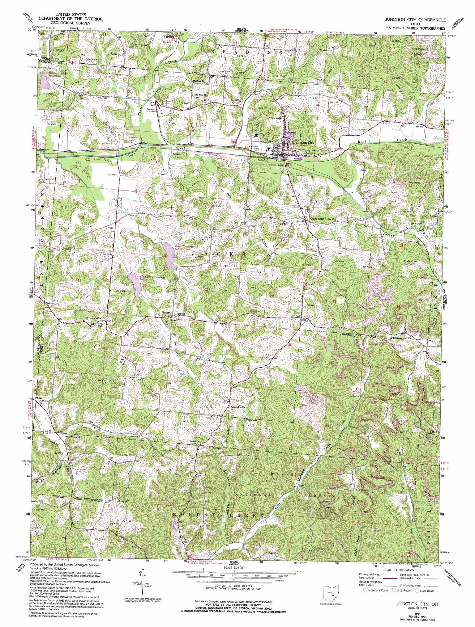
USGS Topo Quad 39082f3 - 1:24,000 scale
| Topo Map Name: | Junction City |
| USGS Topo Quad ID: | 39082f3 |
| Print Size: | ca. 21 1/4" wide x 27" high |
| Southeast Coordinates: | 39.625° N latitude / 82.25° W longitude |
| Map Center Coordinates: | 39.6875° N latitude / 82.3125° W longitude |
| U.S. State: | OH |
| Filename: | o39082f3.jpg |
| Download Map JPG Image: | Junction City topo map 1:24,000 scale |
| Map Type: | Topographic |
| Topo Series: | 7.5´ |
| Map Scale: | 1:24,000 |
| Source of Map Images: | United States Geological Survey (USGS) |
| Alternate Map Versions: |
Junction City OH 1961, updated 1963 Download PDF Buy paper map Junction City OH 1961, updated 1977 Download PDF Buy paper map Junction City OH 1961, updated 1994 Download PDF Buy paper map Junction City OH 2002, updated 2006 Download PDF Buy paper map Junction City OH 2011 Download PDF Buy paper map Junction City OH 2013 Download PDF Buy paper map Junction City OH 2016 Download PDF Buy paper map |
| FStopo: | US Forest Service topo Junction City is available: Download FStopo PDF Download FStopo TIF |
1:24,000 Topo Quads surrounding Junction City
Millersport |
Thornville |
Glenford |
Gratiot |
Zanesville West |
Baltimore |
Rushville |
Somerset |
Fultonham |
Crooksville |
Lancaster |
Bremen |
Junction City |
New Lexington |
Deavertown |
Rockbridge |
Logan |
Gore |
New Straitsville |
Corning |
South Bloomingville |
New Plymouth |
Union Furnace |
Nelsonville |
Jacksonville |
> Back to 39082e1 at 1:100,000 scale
> Back to 39082a1 at 1:250,000 scale
> Back to U.S. Topo Maps home
Junction City topo map: Gazetteer
Junction City: Dams
Rush Creek Conservation District Structure 5a Dam elevation 244m 800′Junction City: Lakes
Flagdale Lake elevation 252m 826′Twin Churches Lake elevation 251m 823′
Junction City: Parks
Junction City Park elevation 250m 820′Junction City: Populated Places
Asbury (historical) elevation 305m 1000′Carthon elevation 249m 816′
Clarksville elevation 304m 997′
Crossenville elevation 306m 1003′
Junction City elevation 254m 833′
Salem elevation 269m 882′
Junction City: Post Offices
Asbury Post Office (historical) elevation 300m 984′Carthon Post Office (historical) elevation 250m 820′
Crossenville Post Office (historical) elevation 298m 977′
Junction City Post Office elevation 253m 830′
Junction City: Reservoirs
Rush Creek Conservation District Structure Reservoir elevation 244m 800′Junction City: Streams
Brehm Run elevation 250m 820′Center Branch Rush Creek elevation 244m 800′
Clark Run elevation 244m 800′
Coalbrook Creek elevation 243m 797′
Dry Run elevation 244m 800′
Lideys Run elevation 249m 816′
Salem Run elevation 244m 800′
Turkey Run elevation 250m 820′
Junction City: Valleys
Coalbrook Hollow elevation 246m 807′Coon Hollow elevation 249m 816′
Junction City digital topo map on disk
Buy this Junction City topo map showing relief, roads, GPS coordinates and other geographical features, as a high-resolution digital map file on DVD:
 map DVD")