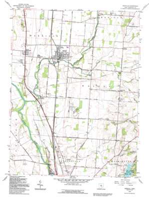
Ashville Topo Map Ohio
To zoom in, hover over the map of Ashville
USGS Topo Quad 39082f8 - 1:24,000 scale
| Topo Map Name: | Ashville |
| USGS Topo Quad ID: | 39082f8 |
| Print Size: | ca. 21 1/4" wide x 27" high |
| Southeast Coordinates: | 39.625° N latitude / 82.875° W longitude |
| Map Center Coordinates: | 39.6875° N latitude / 82.9375° W longitude |
| U.S. State: | OH |
| Filename: | o39082f8.jpg |
| Download Map JPG Image: | Ashville topo map 1:24,000 scale |
| Map Type: | Topographic |
| Topo Series: | 7.5´ |
| Map Scale: | 1:24,000 |
| Source of Map Images: | United States Geological Survey (USGS) |
| Alternate Map Versions: |
Ashville OH 1958, updated 1959 Download PDF Buy paper map Ashville OH 1958, updated 1972 Download PDF Buy paper map Ashville OH 1992, updated 1994 Download PDF Buy paper map Ashville OH 2010 Download PDF Buy paper map Ashville OH 2013 Download PDF Buy paper map Ashville OH 2016 Download PDF Buy paper map |
1:24,000 Topo Quads surrounding Ashville
> Back to 39082e1 at 1:100,000 scale
> Back to 39082a1 at 1:250,000 scale
> Back to U.S. Topo Maps home
Ashville topo map: Gazetteer
Ashville: Dams
Hargus Lake Dam elevation 233m 764′Wolfe Pond Dam elevation 253m 830′
Ashville: Parks
A W Marion Memorial elevation 242m 793′A W Marion State Park elevation 265m 869′
Stages Pond State Nature Preserve elevation 206m 675′
Ashville: Populated Places
Ashville elevation 216m 708′Bells (historical) elevation 208m 682′
Brandon Court elevation 213m 698′
Cromley (historical) elevation 216m 708′
Fairview (historical) elevation 211m 692′
Gray (historical) elevation 219m 718′
Griffith (historical) elevation 217m 711′
Hagerty (historical) elevation 211m 692′
Little Chicago elevation 218m 715′
Little Walnut elevation 210m 688′
Millport elevation 212m 695′
Nebraska (historical) elevation 223m 731′
Rhoads (historical) elevation 218m 715′
Robs Trailer Park elevation 211m 692′
Saint Paul elevation 219m 718′
Scioto Estates elevation 210m 688′
South Bloomfield elevation 212m 695′
Tedrows Mobile Home Park elevation 216m 708′
Voorheis (historical) elevation 215m 705′
Ashville: Post Offices
Ashville Post Office elevation 217m 711′Nebraska Post Office (historical) elevation 223m 731′
Saint Paul Post Office (historical) elevation 219m 718′
South Bloomfield Post Office (historical) elevation 212m 695′
Ashville: Reservoirs
Hargus Lake elevation 233m 764′Wolfe Pond elevation 253m 830′
Ashville: Streams
Bull Run elevation 213m 698′Dry Run elevation 198m 649′
Griffy Run elevation 207m 679′
Lick Run elevation 222m 728′
Little Walnut Creek elevation 207m 679′
Mud Run elevation 203m 666′
Turkey Run elevation 216m 708′
Walnut Creek elevation 201m 659′
Ashville: Trails
Hargus Lake Trail elevation 254m 833′Squawroot Nature Trail elevation 263m 862′
Ashville digital topo map on disk
Buy this Ashville topo map showing relief, roads, GPS coordinates and other geographical features, as a high-resolution digital map file on DVD:


