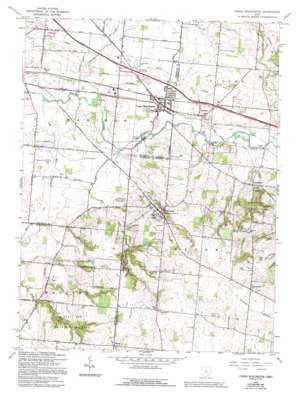
Canal Winchester Topo Map Ohio
To zoom in, hover over the map of Canal Winchester
USGS Topo Quad 39082g7 - 1:24,000 scale
| Topo Map Name: | Canal Winchester |
| USGS Topo Quad ID: | 39082g7 |
| Print Size: | ca. 21 1/4" wide x 27" high |
| Southeast Coordinates: | 39.75° N latitude / 82.75° W longitude |
| Map Center Coordinates: | 39.8125° N latitude / 82.8125° W longitude |
| U.S. State: | OH |
| Filename: | o39082g7.jpg |
| Download Map JPG Image: | Canal Winchester topo map 1:24,000 scale |
| Map Type: | Topographic |
| Topo Series: | 7.5´ |
| Map Scale: | 1:24,000 |
| Source of Map Images: | United States Geological Survey (USGS) |
| Alternate Map Versions: |
Canal Winchester OH 1955, updated 1956 Download PDF Buy paper map Canal Winchester OH 1966, updated 1967 Download PDF Buy paper map Canal Winchester OH 1966, updated 1983 Download PDF Buy paper map Canal Winchester OH 1966, updated 1985 Download PDF Buy paper map Canal Winchester OH 1966, updated 1991 Download PDF Buy paper map Canal Winchester OH 1966, updated 1994 Download PDF Buy paper map Canal Winchester OH 2010 Download PDF Buy paper map Canal Winchester OH 2013 Download PDF Buy paper map Canal Winchester OH 2016 Download PDF Buy paper map |
1:24,000 Topo Quads surrounding Canal Winchester
> Back to 39082e1 at 1:100,000 scale
> Back to 39082a1 at 1:250,000 scale
> Back to U.S. Topo Maps home
Canal Winchester topo map: Gazetteer
Canal Winchester: Bridges
Bergstresser Covered Bridge elevation 228m 748′Loucks Covered Bridge elevation 231m 757′
Canal Winchester: Canals
Tussing Ditch elevation 224m 734′Canal Winchester: Parks
Chestnut Ridge Park elevation 308m 1010′Columbus Street Historic District elevation 232m 761′
North High Street Historic District elevation 232m 761′
Slate Run Metropolitan Park elevation 253m 830′
Stonebridge Park elevation 247m 810′
The Wagnalls Memorial elevation 289m 948′
Village Park elevation 231m 757′
West Mound Street Historic District elevation 232m 761′
Canal Winchester: Populated Places
Beckley Addition elevation 233m 764′Canal Winchester elevation 233m 764′
Greencastle elevation 318m 1043′
Jefferson elevation 260m 853′
Kramers Addition elevation 234m 767′
Lithopolis elevation 288m 944′
Lombardy Heights elevation 235m 770′
Marcy elevation 288m 944′
Slough elevation 297m 974′
Waterloo elevation 237m 777′
Winchester Park Addition elevation 232m 761′
Canal Winchester: Post Offices
Canal Winchester Post Office elevation 232m 761′Green Castle Post Office (historical) elevation 318m 1043′
Lithopolis Post Office elevation 286m 938′
Marcy Post Office (historical) elevation 288m 944′
Slough Post Office (historical) elevation 303m 994′
Canal Winchester: Ridges
Chestnut Ridge elevation 337m 1105′Canal Winchester: Streams
Big Run elevation 221m 725′Dove Run elevation 229m 751′
George Creek elevation 222m 728′
Kramer Run elevation 228m 748′
Running Bear Run elevation 228m 748′
Sycamore Creek elevation 232m 761′
Wild Violet Run elevation 230m 754′
Canal Winchester: Trails
Five Oaks Trail elevation 255m 836′Sassafras Horse Trail elevation 262m 859′
Canal Winchester digital topo map on disk
Buy this Canal Winchester topo map showing relief, roads, GPS coordinates and other geographical features, as a high-resolution digital map file on DVD:


