Millersport Topo Map Ohio
To zoom in, hover over the map of Millersport
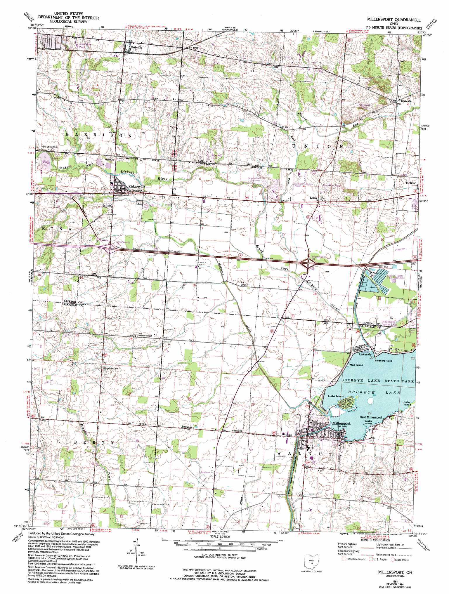
USGS Topo Quad 39082h5 - 1:24,000 scale
| Topo Map Name: | Millersport |
| USGS Topo Quad ID: | 39082h5 |
| Print Size: | ca. 21 1/4" wide x 27" high |
| Southeast Coordinates: | 39.875° N latitude / 82.5° W longitude |
| Map Center Coordinates: | 39.9375° N latitude / 82.5625° W longitude |
| U.S. State: | OH |
| Filename: | o39082h5.jpg |
| Download Map JPG Image: | Millersport topo map 1:24,000 scale |
| Map Type: | Topographic |
| Topo Series: | 7.5´ |
| Map Scale: | 1:24,000 |
| Source of Map Images: | United States Geological Survey (USGS) |
| Alternate Map Versions: |
Millersport OH 1961, updated 1962 Download PDF Buy paper map Millersport OH 1961, updated 1973 Download PDF Buy paper map Millersport OH 1961, updated 1994 Download PDF Buy paper map Millersport OH 2010 Download PDF Buy paper map Millersport OH 2013 Download PDF Buy paper map Millersport OH 2016 Download PDF Buy paper map |
1:24,000 Topo Quads surrounding Millersport
Sunbury |
Johnstown |
Fredonia |
Utica |
Hickman |
New Albany |
Jersey |
Granville |
Newark |
Hanover |
Reynoldsburg |
Pataskala |
Millersport |
Thornville |
Glenford |
Canal Winchester |
Carroll |
Baltimore |
Rushville |
Somerset |
East Ringgold |
Amanda |
Lancaster |
Bremen |
Junction City |
> Back to 39082e1 at 1:100,000 scale
> Back to 39082a1 at 1:250,000 scale
> Back to U.S. Topo Maps home
Millersport topo map: Gazetteer
Millersport: Airports
Buckeye Executive Airport elevation 278m 912′M P W Heliport elevation 280m 918′
Miller Farm Landing Strip elevation 281m 921′
Millersport: Bridges
Holiday Bridge elevation 274m 898′Millersport: Capes
Sellers Point elevation 271m 889′Millersport: Channels
Deep Cut elevation 279m 915′Millersport: Crossings
Interchange 122 elevation 292m 958′Interchange 126 elevation 274m 898′
Millersport: Islands
Castle Island elevation 272m 892′Hickory Island (historical) elevation 274m 898′
Keller Island elevation 272m 892′
Liebs Island elevation 274m 898′
Mud Island elevation 271m 889′
Millersport: Lakes
Deweese Ponds (historical) elevation 269m 882′Hancock Pond elevation 335m 1099′
Millersport: Populated Places
Canyon Villa Estates elevation 278m 912′East Millersport elevation 277m 908′
Happy Homes elevation 327m 1072′
Har-Win Acres elevation 286m 938′
Hollywood by the Lake elevation 270m 885′
Kirkersville elevation 284m 931′
Lakeside elevation 270m 885′
Luray elevation 281m 921′
Millersport elevation 274m 898′
Monticello (historical) elevation 288m 944′
Outville elevation 327m 1072′
Pinecrest Estates elevation 295m 967′
Sandstone Canyon elevation 317m 1040′
Summerland Beach elevation 274m 898′
Sunshine Park elevation 321m 1053′
Wooded Hills elevation 286m 938′
Millersport: Post Offices
Kirkersville Post Office elevation 284m 931′Luray Post Office (historical) elevation 282m 925′
Millersport Post Office elevation 275m 902′
Monticello Post Office (historical) elevation 288m 944′
Millersport: Reservoirs
Buckeye Lake elevation 271m 889′Millersport: Streams
Bell Run elevation 271m 889′Bloody Run elevation 271m 889′
Slim Creek elevation 274m 898′
Millersport: Swamps
Bloody Run Swamp (historical) elevation 270m 885′Millersport digital topo map on disk
Buy this Millersport topo map showing relief, roads, GPS coordinates and other geographical features, as a high-resolution digital map file on DVD:
 map DVD")