Pataskala Topo Map Ohio
To zoom in, hover over the map of Pataskala
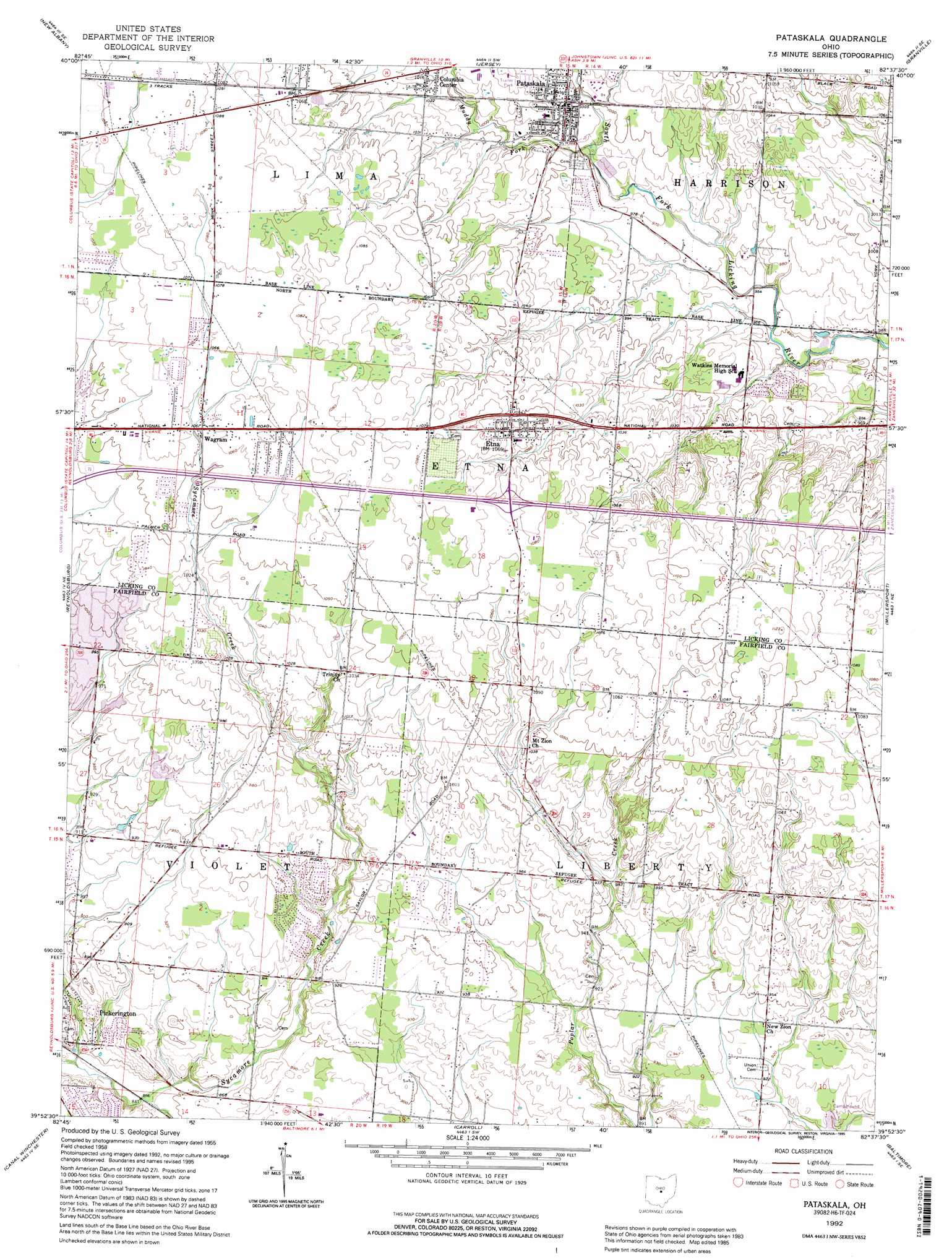
USGS Topo Quad 39082h6 - 1:24,000 scale
| Topo Map Name: | Pataskala |
| USGS Topo Quad ID: | 39082h6 |
| Print Size: | ca. 21 1/4" wide x 27" high |
| Southeast Coordinates: | 39.875° N latitude / 82.625° W longitude |
| Map Center Coordinates: | 39.9375° N latitude / 82.6875° W longitude |
| U.S. State: | OH |
| Filename: | o39082h6.jpg |
| Download Map JPG Image: | Pataskala topo map 1:24,000 scale |
| Map Type: | Topographic |
| Topo Series: | 7.5´ |
| Map Scale: | 1:24,000 |
| Source of Map Images: | United States Geological Survey (USGS) |
| Alternate Map Versions: |
Pataskala OH 1958, updated 1959 Download PDF Buy paper map Pataskala OH 1958, updated 1968 Download PDF Buy paper map Pataskala OH 1958, updated 1975 Download PDF Buy paper map Pataskala OH 1958, updated 1985 Download PDF Buy paper map Pataskala OH 1992, updated 1995 Download PDF Buy paper map Pataskala OH 2010 Download PDF Buy paper map Pataskala OH 2013 Download PDF Buy paper map Pataskala OH 2016 Download PDF Buy paper map |
1:24,000 Topo Quads surrounding Pataskala
Galena |
Sunbury |
Johnstown |
Fredonia |
Utica |
Northeast Columbus |
New Albany |
Jersey |
Granville |
Newark |
Southeast Columbus |
Reynoldsburg |
Pataskala |
Millersport |
Thornville |
Lockbourne |
Canal Winchester |
Carroll |
Baltimore |
Rushville |
Ashville |
East Ringgold |
Amanda |
Lancaster |
Bremen |
> Back to 39082e1 at 1:100,000 scale
> Back to 39082a1 at 1:250,000 scale
> Back to U.S. Topo Maps home
Pataskala topo map: Gazetteer
Pataskala: Crossings
Interchange 118 elevation 327m 1072′Pataskala: Dams
Christian Center Lake Dam elevation 317m 1040′Moore Pond Dam elevation 296m 971′
Pataskala: Parks
Simsbury Park elevation 254m 833′Pataskala: Populated Places
Beals elevation 264m 866′Chevington Woods North elevation 303m 994′
Columbia Center elevation 311m 1020′
Etna elevation 324m 1062′
Pataskala elevation 305m 1000′
Wagram elevation 321m 1053′
Pataskala: Post Offices
Columbia Center Post Office (historical) elevation 311m 1020′Etna Post Office elevation 324m 1062′
Pataskala Post Office elevation 306m 1003′
Wagram Post Office (historical) elevation 321m 1053′
Pataskala: Reservoirs
Christian Center Lake elevation 317m 1040′Moore Pond elevation 296m 971′
Pataskala: Streams
Muddy Fork elevation 298m 977′Pataskala digital topo map on disk
Buy this Pataskala topo map showing relief, roads, GPS coordinates and other geographical features, as a high-resolution digital map file on DVD:
 map DVD")