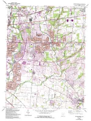
Reynoldsburg Topo Map Ohio
To zoom in, hover over the map of Reynoldsburg
USGS Topo Quad 39082h7 - 1:24,000 scale
| Topo Map Name: | Reynoldsburg |
| USGS Topo Quad ID: | 39082h7 |
| Print Size: | ca. 21 1/4" wide x 27" high |
| Southeast Coordinates: | 39.875° N latitude / 82.75° W longitude |
| Map Center Coordinates: | 39.9375° N latitude / 82.8125° W longitude |
| U.S. State: | OH |
| Filename: | o39082h7.jpg |
| Download Map JPG Image: | Reynoldsburg topo map 1:24,000 scale |
| Map Type: | Topographic |
| Topo Series: | 7.5´ |
| Map Scale: | 1:24,000 |
| Source of Map Images: | United States Geological Survey (USGS) |
| Alternate Map Versions: |
Reynoldsburg OH 1955, updated 1956 Download PDF Buy paper map Reynoldsburg OH 1964, updated 1965 Download PDF Buy paper map Reynoldsburg OH 1964, updated 1974 Download PDF Buy paper map Reynoldsburg OH 1964, updated 1974 Download PDF Buy paper map Reynoldsburg OH 1964, updated 1985 Download PDF Buy paper map Reynoldsburg OH 1964, updated 1995 Download PDF Buy paper map Reynoldsburg OH 2010 Download PDF Buy paper map Reynoldsburg OH 2013 Download PDF Buy paper map Reynoldsburg OH 2016 Download PDF Buy paper map |
1:24,000 Topo Quads surrounding Reynoldsburg
> Back to 39082e1 at 1:100,000 scale
> Back to 39082a1 at 1:250,000 scale
> Back to U.S. Topo Maps home
Reynoldsburg topo map: Gazetteer
Reynoldsburg: Airports
Mount Carmel East Hospital Heliport elevation 265m 869′National Heliport elevation 244m 800′
Reynoldsburg: Bridges
Zeller-Smith Bridge elevation 250m 820′Reynoldsburg: Crossings
Interchange 110 elevation 243m 797′Interchange 112 elevation 263m 862′
Interchange 39 elevation 250m 820′
Interchange 41 elevation 243m 797′
Interchange 43 and 109 elevation 238m 780′
Reynoldsburg: Parks
Big Walnut Park elevation 230m 754′Blacklick Woods Park elevation 265m 869′
Catalpa Park elevation 228m 748′
Far East Park elevation 229m 751′
Hale Park elevation 300m 984′
Huber Park elevation 259m 849′
Independence Village Park elevation 243m 797′
J F Kennedy Park elevation 262m 859′
Kelly Park elevation 231m 757′
Kraner Park elevation 228m 748′
Maybury Park elevation 232m 761′
Maybury School Park elevation 235m 770′
Nafzger Park elevation 226m 741′
Noe-Bixby Park elevation 228m 748′
Orton-Davis Park elevation 243m 797′
Pickerington Pond Wetlands Nature Preserve elevation 238m 780′
Pickerington Ponds Wetlands Wildlife Refuge Park elevation 237m 777′
Pizzuto Park elevation 238m 780′
Portman Park elevation 238m 780′
Shady Lane Park elevation 238m 780′
Shadylane Park elevation 230m 754′
Southway Park elevation 239m 784′
Sycamore Creek Park elevation 250m 820′
Victory Park elevation 252m 826′
Walter A Tucker Nature Preserve elevation 267m 875′
Whitehall Community Park elevation 234m 767′
Willis Park elevation 239m 784′
Reynoldsburg: Populated Places
Blacklick elevation 290m 951′Blacklick Estates elevation 229m 751′
Briarcliff elevation 266m 872′
Brice elevation 239m 784′
Brookside Park elevation 270m 885′
Idlewood Manor elevation 248m 813′
Pickerington elevation 255m 836′
Reynoldsburg elevation 268m 879′
Rose Hill Heights elevation 271m 889′
Summit Station elevation 331m 1085′
Taylor Station elevation 269m 882′
Reynoldsburg: Post Offices
Brice Post Office elevation 240m 787′Pickerington Post Office elevation 256m 839′
Reynoldsburg Post Office elevation 267m 875′
Summit Station Post Office elevation 330m 1082′
Taylor Post Office (historical) elevation 269m 882′
Reynoldsburg: Reservoirs
Ashton Pond elevation 269m 882′Reynoldsburg: Streams
Little Jordan Run elevation 256m 839′Reynoldsburg digital topo map on disk
Buy this Reynoldsburg topo map showing relief, roads, GPS coordinates and other geographical features, as a high-resolution digital map file on DVD:


