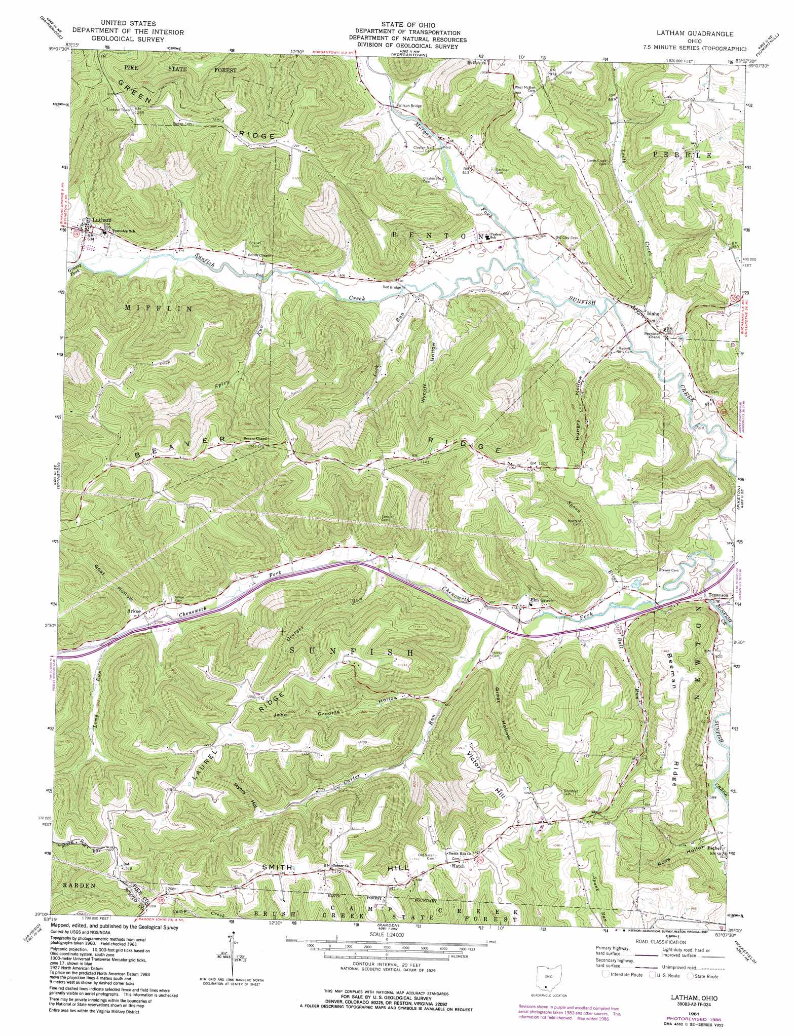
Latham Topo Map Ohio
To zoom in, hover over the map of Latham
USGS Topo Quad 39083a2 - 1:24,000 scale
| Topo Map Name: | Latham |
| USGS Topo Quad ID: | 39083a2 |
| Print Size: | ca. 21 1/4" wide x 27" high |
| Southeast Coordinates: | 39° N latitude / 83.125° W longitude |
| Map Center Coordinates: | 39.0625° N latitude / 83.1875° W longitude |
| U.S. State: | OH |
| Filename: | o39083a2.jpg |
| Download Map JPG Image: | Latham topo map 1:24,000 scale |
| Map Type: | Topographic |
| Topo Series: | 7.5´ |
| Map Scale: | 1:24,000 |
| Source of Map Images: | United States Geological Survey (USGS) |
| Alternate Map Versions: |
Latham OH 1961, updated 1963 Download PDF Buy paper map Latham OH 1961, updated 1967 Download PDF Buy paper map Latham OH 1961, updated 1976 Download PDF Buy paper map Latham OH 1961, updated 1987 Download PDF Buy paper map Latham OH 2010 Download PDF Buy paper map Latham OH 2013 Download PDF Buy paper map Latham OH 2016 Download PDF Buy paper map |
1:24,000 Topo Quads surrounding Latham
Greenfield |
South Salem |
Bourneville |
Chillicothe West |
Chillicothe East |
Rainsboro |
Bainbridge |
Morgantown |
Summithill |
Waverly North |
Sinking Spring |
Byington |
Latham |
Piketon |
Waverly South |
Peebles |
Jaybird |
Rarden |
Wakefield |
Lucasville |
Lynx |
Blue Creek |
Otway |
West Portsmouth |
New Boston |
> Back to 39083a1 at 1:100,000 scale
> Back to 39082a1 at 1:250,000 scale
> Back to U.S. Topo Maps home
Latham topo map: Gazetteer
Latham: Bridges
Red Bridge elevation 179m 587′Wilson Bridge elevation 184m 603′
Latham: Populated Places
Arkoe elevation 216m 708′Elm Grove elevation 189m 620′
Hatch elevation 342m 1122′
Idaho elevation 177m 580′
Latham elevation 192m 629′
Latham: Post Offices
Arkoe Post Office (historical) elevation 214m 702′Elm Grove Post Office elevation 187m 613′
Hatch Post Office (historical) elevation 342m 1122′
Idaho Post Office (historical) elevation 177m 580′
Latham Post Office elevation 191m 626′
Latham: Ridges
Beaver Ridge elevation 366m 1200′Beeman Ridge elevation 287m 941′
Green Ridge elevation 371m 1217′
Laurel Ridge elevation 373m 1223′
Latham: Streams
Bull Run elevation 177m 580′Camp Run elevation 199m 652′
Carter Run elevation 183m 600′
Chenoweth Fork elevation 171m 561′
Georges Run elevation 195m 639′
Grassy Fork elevation 188m 616′
Leeth Creek elevation 173m 567′
Lick Run elevation 180m 590′
Long Run elevation 213m 698′
Long Run elevation 214m 702′
Morgan Fork elevation 177m 580′
Spicy Run elevation 183m 600′
Spoon River elevation 171m 561′
Latham: Summits
Smith Hill elevation 368m 1207′Victory Hill elevation 343m 1125′
Latham: Valleys
Goat Hollow elevation 219m 718′Greer Hollow elevation 203m 666′
Hungry Hollow elevation 197m 646′
Jabe Grooms Hollow elevation 203m 666′
Myers Hollow elevation 259m 849′
Ross Hollow elevation 177m 580′
Wycoff Hollow elevation 192m 629′
Latham digital topo map on disk
Buy this Latham topo map showing relief, roads, GPS coordinates and other geographical features, as a high-resolution digital map file on DVD:
 map DVD")