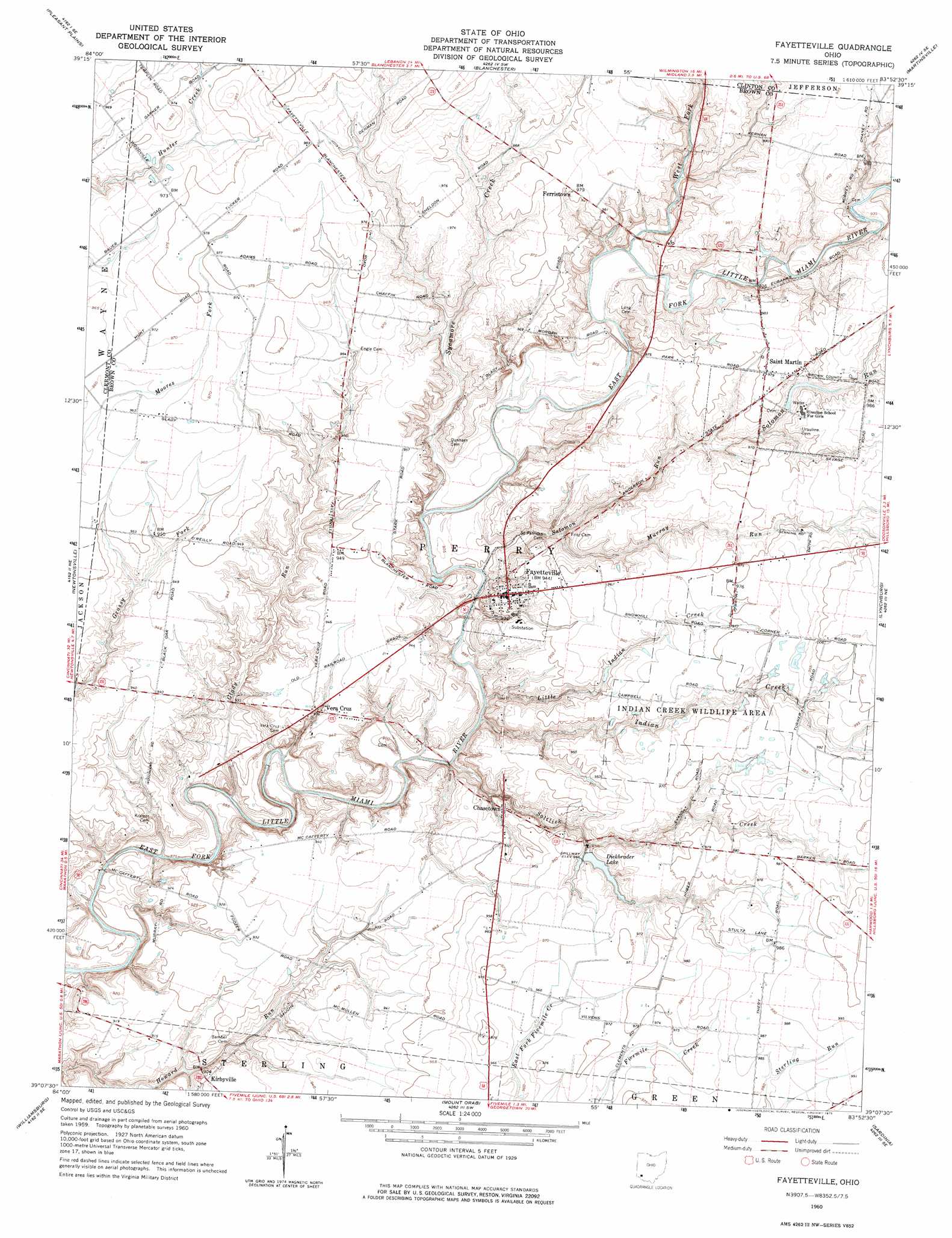
Fayetteville Topo Map Ohio
To zoom in, hover over the map of Fayetteville
USGS Topo Quad 39083b8 - 1:24,000 scale
| Topo Map Name: | Fayetteville |
| USGS Topo Quad ID: | 39083b8 |
| Print Size: | ca. 21 1/4" wide x 27" high |
| Southeast Coordinates: | 39.125° N latitude / 83.875° W longitude |
| Map Center Coordinates: | 39.1875° N latitude / 83.9375° W longitude |
| U.S. State: | OH |
| Filename: | o39083b8.jpg |
| Download Map JPG Image: | Fayetteville topo map 1:24,000 scale |
| Map Type: | Topographic |
| Topo Series: | 7.5´ |
| Map Scale: | 1:24,000 |
| Source of Map Images: | United States Geological Survey (USGS) |
| Alternate Map Versions: |
Fayetteville OH 1960, updated 1962 Download PDF Buy paper map Fayetteville OH 1960, updated 1975 Download PDF Buy paper map Fayetteville OH 2010 Download PDF Buy paper map Fayetteville OH 2013 Download PDF Buy paper map Fayetteville OH 2016 Download PDF Buy paper map |
1:24,000 Topo Quads surrounding Fayetteville
Lebanon |
Oregonia |
Clarksville |
Wilmington |
Sabina |
South Lebanon |
Pleasant Plain |
Blanchester |
Martinsville |
New Vienna |
Goshen |
Newtonsville |
Fayetteville |
Lynchburg |
New Market |
Batavia |
Williamsburg |
Mount Orab |
Sardinia |
Sugar Tree Ridge |
Laurel |
Bethel |
Hamersville |
Ash Ridge |
Winchester |
> Back to 39083a1 at 1:100,000 scale
> Back to 39082a1 at 1:250,000 scale
> Back to U.S. Topo Maps home
Fayetteville topo map: Gazetteer
Fayetteville: Airports
Double J Airport elevation 295m 967′Fayetteville: Bridges
McCafferty Road Bridge elevation 263m 862′Fayetteville: Dams
Dieckbrader Lake Dam elevation 287m 941′Evans Lake Dam elevation 288m 944′
Lake Fichtelberg Dam elevation 289m 948′
Lake Lorelei Dam elevation 278m 912′
Pschesang Lake Dam elevation 294m 964′
Winandi Lake Dam elevation 291m 954′
Fayetteville: Parks
Bott Wildlife Area elevation 297m 974′Indian Creek Wildlife Area elevation 297m 974′
Fayetteville: Populated Places
Chasetown elevation 287m 941′Fayetteville elevation 289m 948′
Ferristown elevation 298m 977′
Kirbyville elevation 283m 928′
Saint Martin elevation 298m 977′
Vera Cruz elevation 285m 935′
Fayetteville: Post Offices
Chasetown Post Office (historical) elevation 287m 941′Fayetteville Post Office elevation 288m 944′
Saint Martin Post Office elevation 298m 977′
Veracruz Post Office (historical) elevation 285m 935′
Fayetteville: Reservoirs
Dieckbrader Lake elevation 287m 941′Evans Lake elevation 288m 944′
Lake Fichtelberg elevation 289m 948′
Lake Lorelei elevation 278m 912′
Pschesang Lake elevation 294m 964′
Winandi Reservoir elevation 291m 954′
Fayetteville: Streams
Glady Run elevation 267m 875′Indian Creek elevation 272m 892′
Little Indian Creek elevation 270m 885′
Murray Run elevation 278m 912′
Saltlick Creek elevation 271m 889′
Solomon Run elevation 273m 895′
Sycamore Creek elevation 272m 892′
West Fork East Fork Little Miami River elevation 277m 908′
Fayetteville digital topo map on disk
Buy this Fayetteville topo map showing relief, roads, GPS coordinates and other geographical features, as a high-resolution digital map file on DVD:
 map DVD")