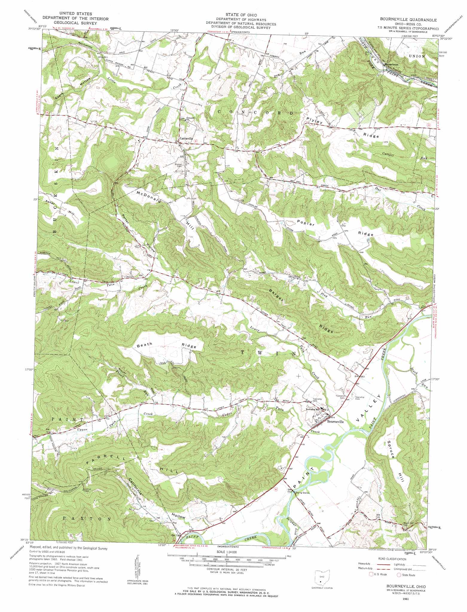
Bourneville Topo Map Ohio
To zoom in, hover over the map of Bourneville
USGS Topo Quad 39083c2 - 1:24,000 scale
| Topo Map Name: | Bourneville |
| USGS Topo Quad ID: | 39083c2 |
| Print Size: | ca. 21 1/4" wide x 27" high |
| Southeast Coordinates: | 39.25° N latitude / 83.125° W longitude |
| Map Center Coordinates: | 39.3125° N latitude / 83.1875° W longitude |
| U.S. State: | OH |
| Filename: | o39083c2.jpg |
| Download Map JPG Image: | Bourneville topo map 1:24,000 scale |
| Map Type: | Topographic |
| Topo Series: | 7.5´ |
| Map Scale: | 1:24,000 |
| Source of Map Images: | United States Geological Survey (USGS) |
| Alternate Map Versions: |
Bourneville OH 1961, updated 1962 Download PDF Buy paper map Bourneville OH 2010 Download PDF Buy paper map Bourneville OH 2013 Download PDF Buy paper map Bourneville OH 2016 Download PDF Buy paper map |
1:24,000 Topo Quads surrounding Bourneville
Washington Court House |
New Holland |
Clarksburg |
Williamsport |
Circleville |
New Martinsburg |
Good Hope |
Frankfort |
Andersonville |
Kingston |
Greenfield |
South Salem |
Bourneville |
Chillicothe West |
Chillicothe East |
Rainsboro |
Bainbridge |
Morgantown |
Summithill |
Waverly North |
Sinking Spring |
Byington |
Latham |
Piketon |
Waverly South |
> Back to 39083a1 at 1:100,000 scale
> Back to 39082a1 at 1:250,000 scale
> Back to U.S. Topo Maps home
Bourneville topo map: Gazetteer
Bourneville: Populated Places
Bourneville elevation 207m 679′Lattaville elevation 271m 889′
Musselman elevation 213m 698′
Bourneville: Post Offices
Bourneville Post Office elevation 207m 679′Musselman Post Office elevation 211m 692′
Bourneville: Ridges
Barger Ridge elevation 316m 1036′Beath Ridge elevation 349m 1145′
Farrell Hill elevation 385m 1263′
McDonald Hill elevation 348m 1141′
Plyley Ridge elevation 329m 1079′
Poplar Ridge elevation 329m 1079′
Spruce Hill elevation 316m 1036′
Bourneville: Streams
Black Run elevation 201m 659′Latta Run elevation 241m 790′
Lower Twin Creek elevation 206m 675′
Plug Run elevation 201m 659′
Proud Run elevation 219m 718′
Reeves Run elevation 201m 659′
Sulphur Lick elevation 207m 679′
Sulphur Lick elevation 206m 675′
Upper Twin Creek elevation 206m 675′
Bourneville: Summits
Asher Hill elevation 390m 1279′Bourneville: Valleys
California Hollow elevation 215m 705′Eagle Hollow elevation 254m 833′
Porter Hollow elevation 232m 761′
Bourneville digital topo map on disk
Buy this Bourneville topo map showing relief, roads, GPS coordinates and other geographical features, as a high-resolution digital map file on DVD:
 map DVD")