New Vienna Topo Map Ohio
To zoom in, hover over the map of New Vienna
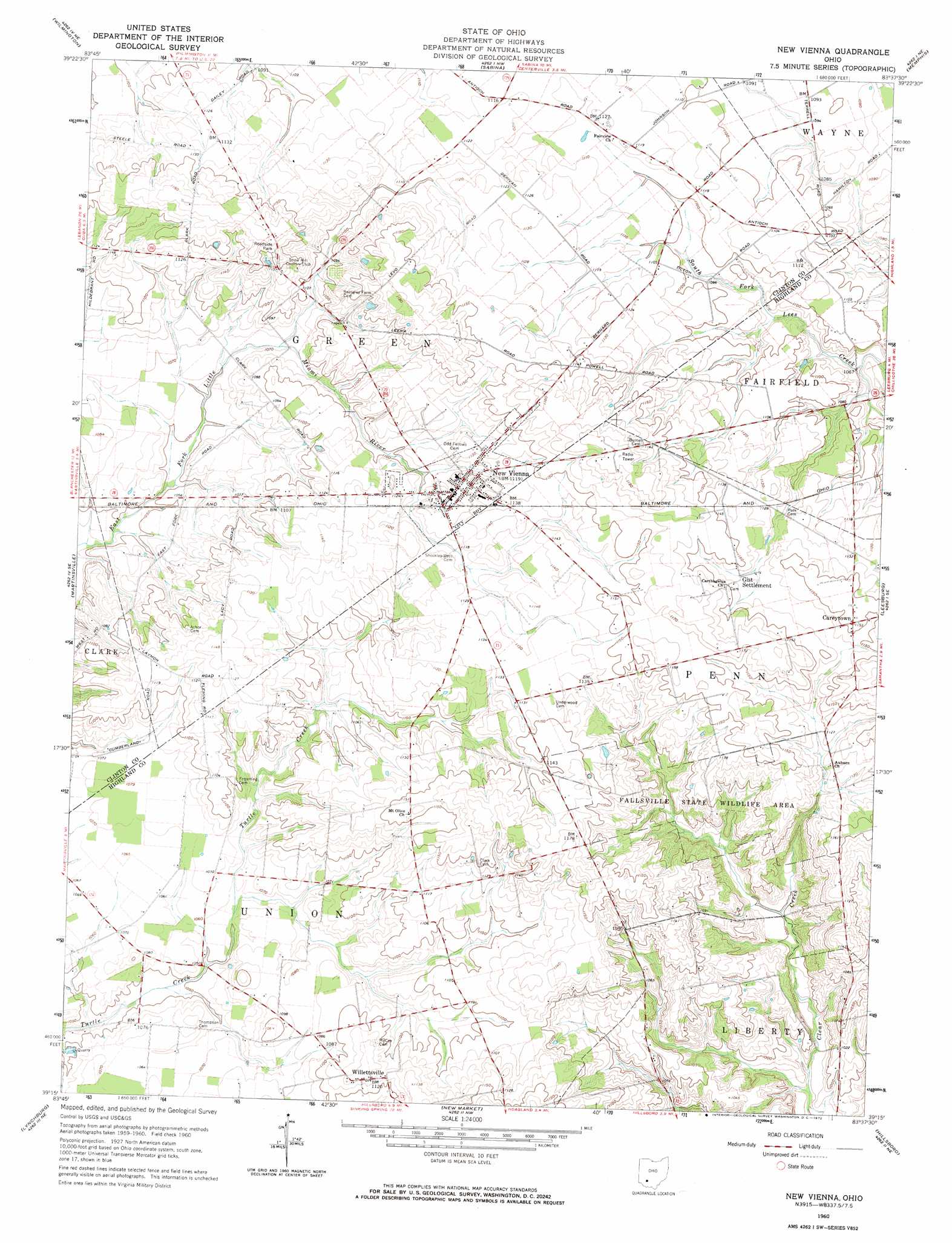
USGS Topo Quad 39083c6 - 1:24,000 scale
| Topo Map Name: | New Vienna |
| USGS Topo Quad ID: | 39083c6 |
| Print Size: | ca. 21 1/4" wide x 27" high |
| Southeast Coordinates: | 39.25° N latitude / 83.625° W longitude |
| Map Center Coordinates: | 39.3125° N latitude / 83.6875° W longitude |
| U.S. State: | OH |
| Filename: | o39083c6.jpg |
| Download Map JPG Image: | New Vienna topo map 1:24,000 scale |
| Map Type: | Topographic |
| Topo Series: | 7.5´ |
| Map Scale: | 1:24,000 |
| Source of Map Images: | United States Geological Survey (USGS) |
| Alternate Map Versions: |
New Vienna OH 1960, updated 1962 Download PDF Buy paper map New Vienna OH 1960, updated 1972 Download PDF Buy paper map New Vienna OH 2010 Download PDF Buy paper map New Vienna OH 2013 Download PDF Buy paper map New Vienna OH 2016 Download PDF Buy paper map |
1:24,000 Topo Quads surrounding New Vienna
New Burlington |
Port William |
Bowersville |
Milledgeville |
Washington Court House |
Clarksville |
Wilmington |
Sabina |
Memphis |
New Martinsburg |
Blanchester |
Martinsville |
New Vienna |
Leesburg |
Greenfield |
Fayetteville |
Lynchburg |
New Market |
Hillsboro |
Rainsboro |
Mount Orab |
Sardinia |
Sugar Tree Ridge |
Belfast |
Sinking Spring |
> Back to 39083a1 at 1:100,000 scale
> Back to 39082a1 at 1:250,000 scale
> Back to U.S. Topo Maps home
New Vienna topo map: Gazetteer
New Vienna: Airports
Terrell Airport elevation 347m 1138′New Vienna: Parks
Fallsville State Wildlife Area elevation 329m 1079′New Vienna: Populated Places
Careytown elevation 351m 1151′Emerald Pines Mobile Home Park elevation 339m 1112′
Fallsville (historical) elevation 343m 1125′
Gist Settlement elevation 348m 1141′
New Vienna elevation 342m 1122′
Sharpsville (historical) elevation 317m 1040′
Snow Hill elevation 350m 1148′
Willettsville elevation 340m 1115′
New Vienna: Post Offices
Bloomington Post Office (historical) elevation 341m 1118′Careytown Post Office (historical) elevation 351m 1151′
New Vienna Post Office elevation 340m 1115′
Sharpsville Post Office (historical) elevation 318m 1043′
Snow Hill Post Office (historical) elevation 342m 1122′
Willettville Post Office (historical) elevation 342m 1122′
New Vienna digital topo map on disk
Buy this New Vienna topo map showing relief, roads, GPS coordinates and other geographical features, as a high-resolution digital map file on DVD:
 map DVD")