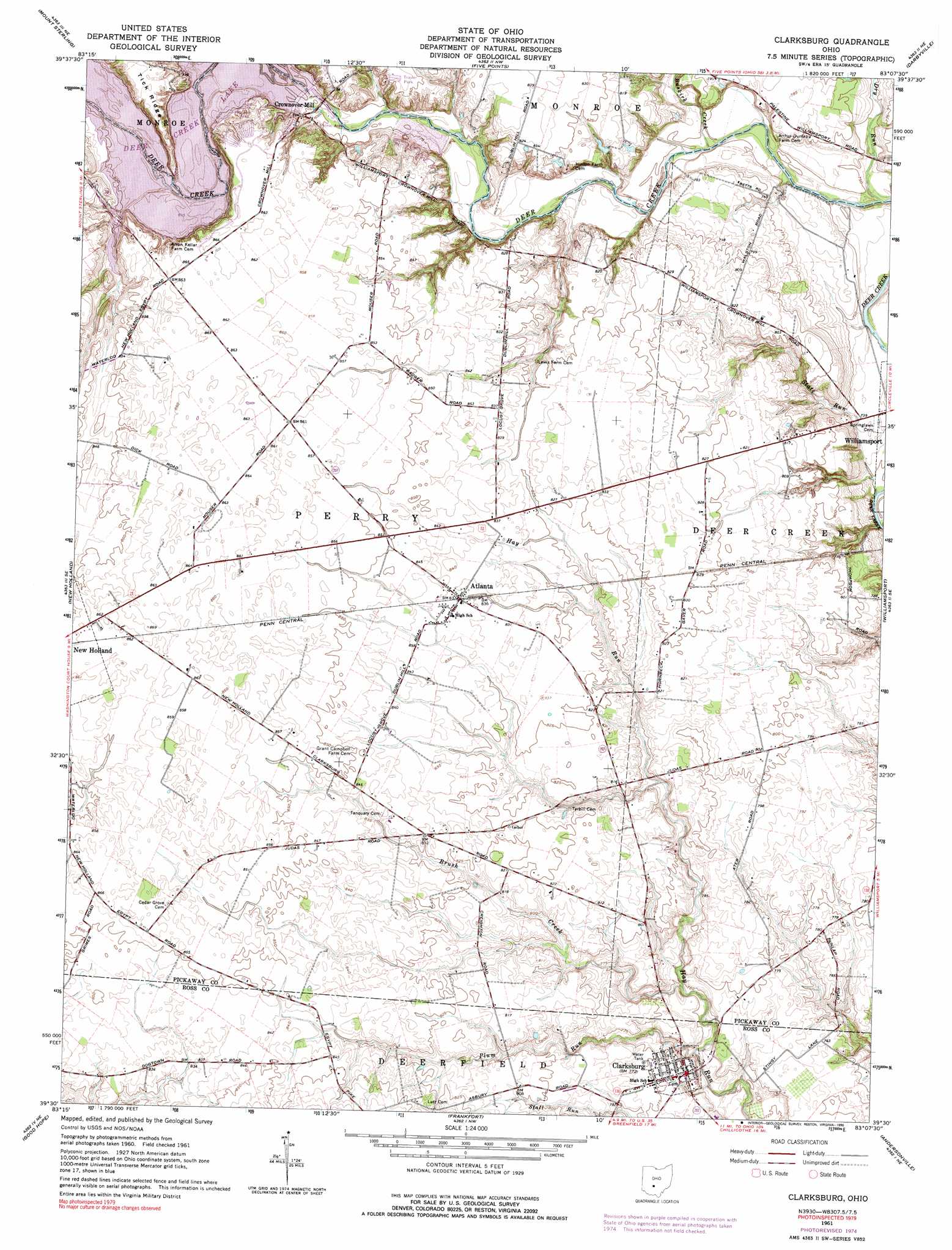
Clarksburg Topo Map Ohio
To zoom in, hover over the map of Clarksburg
USGS Topo Quad 39083e2 - 1:24,000 scale
| Topo Map Name: | Clarksburg |
| USGS Topo Quad ID: | 39083e2 |
| Print Size: | ca. 21 1/4" wide x 27" high |
| Southeast Coordinates: | 39.5° N latitude / 83.125° W longitude |
| Map Center Coordinates: | 39.5625° N latitude / 83.1875° W longitude |
| U.S. State: | OH |
| Filename: | o39083e2.jpg |
| Download Map JPG Image: | Clarksburg topo map 1:24,000 scale |
| Map Type: | Topographic |
| Topo Series: | 7.5´ |
| Map Scale: | 1:24,000 |
| Source of Map Images: | United States Geological Survey (USGS) |
| Alternate Map Versions: |
Clarksburg OH 1961, updated 1963 Download PDF Buy paper map Clarksburg OH 1961, updated 1975 Download PDF Buy paper map Clarksburg OH 1961, updated 1990 Download PDF Buy paper map Clarksburg OH 2010 Download PDF Buy paper map Clarksburg OH 2013 Download PDF Buy paper map Clarksburg OH 2016 Download PDF Buy paper map |
1:24,000 Topo Quads surrounding Clarksburg
Walnut Run |
Big Plain |
Harrisburg |
Commercial Point |
Lockbourne |
Midway |
Mount Sterling |
Five Points |
Darbyville |
Ashville |
Washington Court House |
New Holland |
Clarksburg |
Williamsport |
Circleville |
New Martinsburg |
Good Hope |
Frankfort |
Andersonville |
Kingston |
Greenfield |
South Salem |
Bourneville |
Chillicothe West |
Chillicothe East |
> Back to 39083e1 at 1:100,000 scale
> Back to 39082a1 at 1:250,000 scale
> Back to U.S. Topo Maps home
Clarksburg topo map: Gazetteer
Clarksburg: Dams
Deercreek Dam elevation 240m 787′Dunlap Lake Dam elevation 249m 816′
Dunlap Pond Dam Number Three elevation 247m 810′
Dunlap Pond Dam Number Two elevation 247m 810′
Clarksburg: Populated Places
Atlanta elevation 256m 839′Clarksburg elevation 235m 770′
Crownover Mill elevation 246m 807′
Kozy Corners elevation 259m 849′
Clarksburg: Post Offices
Atlanta Post Office elevation 256m 839′Clarksburg Post Office elevation 234m 767′
Clarksburg: Reservoirs
Deer Creek Lake elevation 240m 787′Dunlap Lake elevation 249m 816′
Dunlap Pond Number Three elevation 247m 810′
Dunlap Pond Number Two elevation 247m 810′
Clarksburg: Streams
Brush Creek elevation 226m 741′Buskirk Creek elevation 226m 741′
Dry Run elevation 224m 734′
Georges Run elevation 244m 800′
Plum Run elevation 222m 728′
State Run elevation 219m 718′
Clarksburg digital topo map on disk
Buy this Clarksburg topo map showing relief, roads, GPS coordinates and other geographical features, as a high-resolution digital map file on DVD:
 map DVD")