Washington Court House Topo Map Ohio
To zoom in, hover over the map of Washington Court House
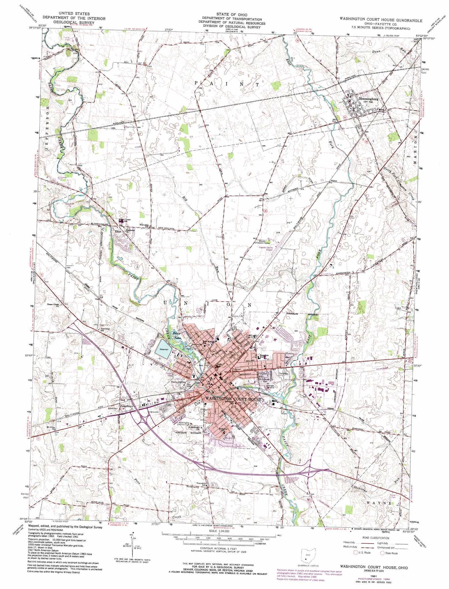
USGS Topo Quad 39083e4 - 1:24,000 scale
| Topo Map Name: | Washington Court House |
| USGS Topo Quad ID: | 39083e4 |
| Print Size: | ca. 21 1/4" wide x 27" high |
| Southeast Coordinates: | 39.5° N latitude / 83.375° W longitude |
| Map Center Coordinates: | 39.5625° N latitude / 83.4375° W longitude |
| U.S. State: | OH |
| Filename: | o39083e4.jpg |
| Download Map JPG Image: | Washington Court House topo map 1:24,000 scale |
| Map Type: | Topographic |
| Topo Series: | 7.5´ |
| Map Scale: | 1:24,000 |
| Source of Map Images: | United States Geological Survey (USGS) |
| Alternate Map Versions: |
Washington Court House OH 1961, updated 1963 Download PDF Buy paper map Washington Court House OH 1961, updated 1975 Download PDF Buy paper map Washington Court House OH 1961, updated 1987 Download PDF Buy paper map Washington Court House OH 2010 Download PDF Buy paper map Washington Court House OH 2013 Download PDF Buy paper map Washington Court House OH 2016 Download PDF Buy paper map |
1:24,000 Topo Quads surrounding Washington Court House
South Charleston |
Florence |
Walnut Run |
Big Plain |
Harrisburg |
Jamestown |
Jeffersonville |
Midway |
Mount Sterling |
Five Points |
Bowersville |
Milledgeville |
Washington Court House |
New Holland |
Clarksburg |
Sabina |
Memphis |
New Martinsburg |
Good Hope |
Frankfort |
New Vienna |
Leesburg |
Greenfield |
South Salem |
Bourneville |
> Back to 39083e1 at 1:100,000 scale
> Back to 39082a1 at 1:250,000 scale
> Back to U.S. Topo Maps home
Washington Court House topo map: Gazetteer
Washington Court House: Airports
Fayette County Airport elevation 299m 980′Washington Court House: Canals
Green Ditch elevation 299m 980′Washington Court House: Dams
Washington Court House Reservoir Dam elevation 301m 987′Washington Court House: Parks
Christman Memorial Park elevation 289m 948′Eyman Park elevation 292m 958′
Fayette County Fair Grounds elevation 299m 980′
Gardner Athletic Field elevation 290m 951′
Roszmann Field elevation 294m 964′
Washington Cemetery Historic District elevation 291m 954′
Washington Court House Commercial Historic District elevation 297m 974′
Washington Park elevation 294m 964′
Washington Court House: Populated Places
Bloomingburg elevation 303m 994′Eber elevation 305m 1000′
Jonesboro elevation 306m 1003′
Olympia (historical) elevation 289m 948′
Washington Court House elevation 297m 974′
Washington Oaks elevation 295m 967′
Washington Court House: Post Offices
Bloomingburg Post Office elevation 303m 994′Eber Post Office (historical) elevation 305m 1000′
Washington Court House Post Office elevation 295m 967′
Washington Court House: Reservoirs
Washington Court House Reservoir elevation 301m 987′Washington Court House: Streams
Big Run elevation 292m 958′East Fork Paint Creek elevation 288m 944′
Washington Court House digital topo map on disk
Buy this Washington Court House topo map showing relief, roads, GPS coordinates and other geographical features, as a high-resolution digital map file on DVD:
 map DVD")